NOAA’s National Weather Service Southeast and Caribbean regional teams presented a webinar for reporters, emergency managers, businesses, and others affected by the weather last week to give us a look at what the current very strong El Ni?o will mean for our winter here on the Outer Banks.
The take-away in a nutshell is that we can expect a very wet winter, but it’s not yet clear if all that extra precipitation will come in the form of rain or something frozen. The temperature forecast for this El Ni?o is less clear for our area.
There were three presenters for the webinar:
- Victor Murphy, NWS Southern Regional climate service program manager.
- Chip Konrad, NOAA’s Southeast Regional Climate Center at the University of North Carolina at Chapel Hill.
- Jon Gottschalck, chief of the Operational Prediction Branch of the NOAA/NWS Climate Prediction Center.
The message from all three was quite clear — we are currently in a very strong El Ni?o, one that may set a record before it ends, perhaps in the spring or early summer.
Just for background, an El Ni?o event occurs when warmer-than-average sea surface temperatures persist across the equatorial Pacific Ocean for periods of six to 12 months or longer. Typically, according to the Weather Service, El Ni?os occur every two to seven years.
The current El Ni?o has been in progress for much of this year and brought us a mostly quieter than usual hurricane season. The current El Ni?o is expected to peak this winter.

“We’re close to uncharted territory,” Gottschalck said. “This could be in the top two or three El Ni?o events since 1950.”
This year’s event is already rated second strongest for the August through October period, and could go for the record before it ends late this winter. So far, the two strongest on record were during 1982-83 and 1997-98.
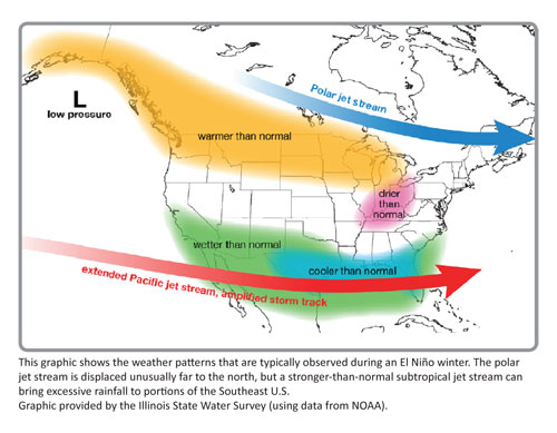
The meteorologists stressed that every El Ni?o event is different, but there are some commonalities. The polar jet stream is usually displaced farther to the north during an El Ni?o, while a stronger than normal sub-tropical jet stream often affects the southern states.
Indeed, according to Gottschalck, the outlook is for a storm track that shifts to the south and favors above normal precipitation in the southeast with the potential for some strong storms.
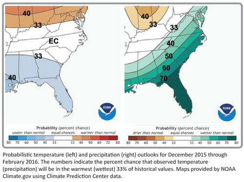
In eastern North Carolina, the NWS long-range forecast for December through February is for a 60 percent chance of more precipitation.
Gottschalck says there is more uncertainty in the temperature forecast for eastern North Carolina than in the precipitation forecast.
Generally, colder than normal temperatures are expected in Texas and across the Gulf Coast, including Florida.

However, generally, North Carolina has equal chances — or close to it — for warm, cold, or average temperatures. For December through February, there’s a 37 percent chance temps will be above average, while there’s a 33 percent chance of normal temps and a 30 percent chance that they will be below normal.
Konrad said that the southeast may be looking at “more, cool cloudy days.”
The maximum temperatures may be cooler than normal, but the minimum temperatures will be about normal. The means, he said, “there is less chance of really cold air, but the chances aren’t zero.”
Gottschalck was asked directly about the Carolinas. Will we have snow and ice or just rain?
There have been El Ni?o winters, he said, when the area has had a lot of snow, and there have been other El Ni?o winters, in which the region has seen very little snow.
“It’s just difficult to say this far in advance,” he said.
The big players in snow and ice vs. rain are the Arctic Oscillation and the North Atlantic Oscillation, which modulate circulation patterns over the high latitudes, thereby regulating the number and intensity of cold air outbreaks in the U.S.
These two circulation patterns can’t be reliably predicted more than just a few weeks in advance.
That’s why Gottschalck stresses in his presentation:
“El Ni?o changes the odds for certain impacts. The percentage shift tends to be larger for stronger El Ni?o events. But, impacts are never guaranteed in seasonal climate prediction because there are unpredictable elements that influence the result.”
That would be the Arctic and North Atlantic Oscillations — may they stay far north of the Outer Banks this winter.
I’ve read that The Old Farmer’s Almanac is predicting a chilly and wet winter for the southeast. Haven’t heard much about the woolly worms or the acorns or anything like that.
I can tell you that my very large and lovely cactus plant is neither a true Thanksgiving cactus nor Christmas cactus. When it blooms has varied from year to year since I bought it more than 20 years ago.
I’ve never tried to relate it to the winter temperatures, but I think I’ll start now.
So, last year, we had a cold and nasty winter and my cactus bloomed just before Christmas. This year, it is blooming at Thanksgiving — almost a full month earlier.
I hope that means a warmer winter. Looks like we’ll just have to put up with the rain.
FOR MORE INFORMATION
Click here to see the three PowerPoint presentations from the NOAA/NWS presentation on El Ni?o in the Southeast.


