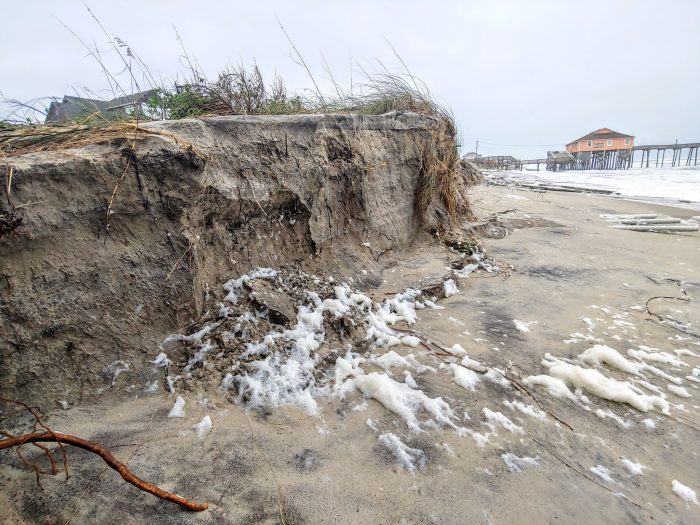
The National Park Service held informational webinars this week to discuss the Draft Environmental Impact Statement (EIS) for a 20-year sediment management framework for the Cape Hatteras National Seashore (CHNS), and to solicit the public’s feedback on the preferred plan for future beach nourishment, dune restoration, and breach repair projects.
“This is a very dynamic place [with] erosion rates of up to 10 feet per year,” said National Parks of Eastern North Carolina Superintendent David Hallac at Wednesday’s meeting, noting that the Outer Banks had some of the highest erosion rates on the East Coast. “…That’s a good lead into our sediment management framework, and why we’re meeting today.”
Natural accretion and erosion processes have impacted the Hatteras and Ocracoke island shorelines for decades due to anthropogenic activities, (like dune building, dune planting, inlet dredging, and dune maintenance), as well as other factors, like sea level rise.
As such, sediment management efforts have been utilized along the shoreline to control erosion and stabilize sand dunes for decades, from active dune building in the 1930s-1960s, to recent beach nourishment projects in the past few years.
Since the 1970s, localized beach nourishment has been the primary method of combating shoreline erosion, but so far, it has been restricted to Ocracoke Island, the Buxton area, and Rodanthe. In some places, segments of the beach are relatively stable, and natural processes maintain a line of strong sand dunes. In other hot spots on the islands, however, erosion of the shoreline has resulted in the semi-regular overwash of N.C. Highway 12, as well as adjacent communities.
So in order to provide a faster way to address these erosion-related project requests, the National Park Service first published a Notice of Intent in the Federal Register on April 10 to prepare an Environmental Impact Statement (EIS) for sediment management within the National Seashore.
The purpose of the EIS is to develop a streamlined framework for implementing sediment management projects, which includes the method, location, and frequency for sediment management actions that may be permitted over the next 20 years.
CHNS has received various requests, (and anticipate future requests), to issue special use permits for protecting roads and bridges, repairing island damages, and restoring habitats through the placement of dredged materials along eroded sections of the barrier islands.
A formal sediment management framework will allow the NPS to provide timely responses for localized beach nourishment requests, and is needed to assist CHNS to address these current and future project proposals.
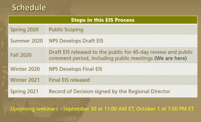
The webinars that are being hosted this week are the third stage in the roughly 12-month process to develop the sediment management framework.
In the summer of 2020, the NPS developed a Draft EIS with their preferred option for the upcoming framework, and currently, the Draft EIS is in a 45-day review and public comment period.
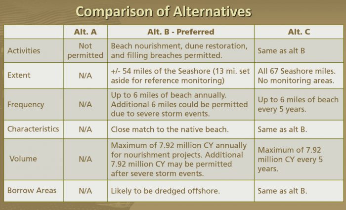
The three alternatives that were considered for the Draft EIS are as follows:
- Alternative A: No-Action – The NPS would not permit sediment management activities at the National Seashore over the next two decades. The no-action alternative would preclude CHNS partners, such as the NCDOT, from implementing sediment management to protect N.C. Highway 12 outside of its existing easement, and Dare County to perform beach nourishment projects along the National Seashore. This option is not recommended by the NPS.
- Alternative B: PREFERRED ALTERNATIVE – The NPS could permit other agencies and municipalities to conduct, with conditions, sediment management in the form of:
- Beach nourishment
- Dune restoration
- Emergency breach fill
- These projects could cover up to six miles of beach annually, and an additional six miles of shoreline could also be permitted in the event of severe storm events.
- In addition, a maximum of 7.92 million cubic yards of sand would be permitted annually for nourishment projects, and an additional 7.92 million cubic yards of sand could also be permitted In the case of severe storm events.
- Alternative C: Alternative C would be a continuation of ad hoc permitting, where sediment management can occur for up to six miles of shoreline every five years. “This is meant to convey continuing the things that we do now,” said Hallac. “When a permit request comes in, we look at it… and we issue a permit after an environmental review process.”
During the meetings, Hallac outlined why Alternative B was chosen as the preferred option for the sediment management framework, and explained the details of what the framework would entail, using the recent impacts from Sally and Teddy as examples.
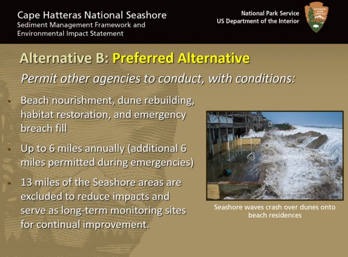
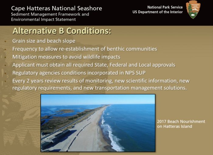
Under Alternative B, the NPS would permit other agencies to conduct all of the above projects without the waiting period that is currently required, provided that specific conditions, (like mitigation measures to protect local wildlife), are followed.
In addition, 13 miles of the CHNS’s 67 miles of shoreline would be set aside and untouched as reference areas in order to monitor and gauge erosion rates within the National Seashore. These areas are not adjacent to a highway or village, and have low erosion rates or significant beach width. (An example is the shoreline just south of the Tri-Villages, where there is roughly 2,000 feet of area between the ocean and the highway.)
The 45-day comment period began on September 18, 2020 and ends on November 2, 2020.
The Final EIS is expected to be released in the winter of 2020, and the Record of Decision is expected to be complete by the spring of 2021.
How to Comment
Comments can be submitted electronically at https://parkplanning.nps.gov/CAHASediment, which is the preferred method.
Comments can also be mailed or hand-delivered to “Cape Hatteras Sediment Management EIS Superintendent, Cape Hatteras National Seashore, 1401 National Park Drive, Manteo, NC 27954
Upcoming Webinars
A third public review webinar is slated for Thursday, October 1, at 7:00 p.m. and the public can tune via the following login info:
- October 1, 7:00-8:00 PM ET
- Link: https://register.gotowebinar.com/register/3045951083777996813
- Webinar ID: 692-546-131
For more information on the project, visit https://parkplanning.nps.gov/projectHome.cfm?projectID=94076.


It’s so nice to have a Superintendent that understands and appreciates the need to maintain and protect the shorelines and local communities of Hatteras and Ocracoke Islands.