Colin brushes by Cape Hatteras, races out to sea By IRENE NOLAN
The National Weather Service lifted all tropical storm warnings and flash flood watches for North Carolina coast, including Hatteras and Ocracoke islands, at 2 p.m. this afternoon.
After a night of heavy — but apparently not record — rainfall, the sun was shining by 2 this afternoon, even as the National Hurricane Center reported that the center of now Post-tropical Storm Colin was located just 25 miles east of Cape Hatteras.
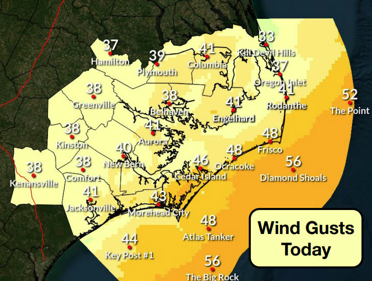
The Hurricane Center said Colin’s maximum sustained winds were near 60 mph with higher gusts. Some slight strengthening is possible today and tonight, but gradual weakening is expected to begin on Wednesday. Colin was moving northeast at the very rapid speed of 38 mph.
By the 5 p.m. advisory, the storm was 205 miles east-northeast of Cape Hatteras and speeding along out to sea at 40 mph.
The system’s strongest winds and heaviest rains were located over water well southeast of the center as Colin brushed by Hatteras and Ocracoke a bit more to the east than had been forecast.
Showers and thunderstorms began on the island on Monday afternoon, and the rain continued overnight and into this morning — heavy at times. However, by about 1 p.m., it was as if the spigot had been turned off and patches of blue began appearing in the sky. It wasn’t long after that before the sun was shining brightly.
Several inches of rain fell — 3.03 inches in 24 hours at my rain gauge in Brigand’s Bay in Frisco — which is about what had been forecast but well below the records that were set last week by Tropical Depression Bonnie.
Highway 12 and side roads were covered with water in low spots this morning in the usual places — the tri-villages, south Avon, and eastern Hatteras village — but conditions were improving into the afternoon under sunny and less humid skies.
Many yards in front of houses on the islands looked more like lakes than puddles as the rain was only slowed drained by the already saturated soil.
Winds did pick up this morning on Hatteras and Ocracoke, but the gusty winds were also short-lived. A gust of 44 mph was recorded at about 9:30 a.m. at Billy Mitchell Airport in Frisco. About the same time, a gust of 49 was measured at Diamond Shoals buoy.
A small craft advisory for seas remains in effect for coastal waters south of Oregon Inlet into tonight. Seas were running about 10 feet offshore but were expected to subside to below 6 feet over night.
The Weather Service was also warning beachgoers of a high threat of rip currents and dangerous shorebreak.
The National Park Service began opening its facilities at Cape Hatteras National Seashore this afternoon.
In a news release, the Park Service said that rainfall from Tropical Storm Colin, combined with historic rainfall over the past month, has flooded multiple sites within the seashore.
Here is the status of seashore facilities, ramps, and campgrounds on Tuesday afternoon:
Facilities: The Ocracoke Visitor Center, Ocracoke Off-Road Vehicle (ORV) Permit Office, Bodie Island Visitor Center, Bodie Island ORV Permit Office, and Bodie Island Lighthouse are now reopened. The Hatteras Island Visitor Center, Hatteras Island ORV Permit Office, and Cape Hatteras Lighthouse remain temporarily closed due to flooding in that area. Staff will continue to assess the area and reopen as soon as it is safe to do so. Visitors looking to purchase an ORV permit may do so online at recreation.gov.
Beach Access Ramps: The condition of beach access ramps continues to be assessed. Flooding has been extensive on multiple ramps. ORV permit holders should check for posted temporary closure signs before entering any ramp. ORV permit holders should use best judgment when accessing any open ramp. Daily ramp status updates are available on the Cape Hatteras National Seashore Facebook page at http://facebook.com/capehatterasns.
Campgrounds: The Oregon Inlet, Frisco, and Ocracoke campgrounds are currently open. However, some campsites are flooded. Check recreation.gov for availability. Campsites will reopen daily as conditions improve. Cape Point Campground is temporarily closed due to flooded conditions and will reopen as conditions improve.
The National Weather Service is promising warm, dry, and less humid weather for the rest of the week. Temperatures are forecast to be in the upper 70s to around 80 at the coast and there is no mention of rain.
For more information on the forecasts, go to the local Weather Service website at www.weather.gov/mhx/.


