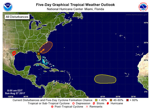
While Hurricane Harvey devastates the western Gulf Coast region, a weak tropical system may form off the Southeastern U.S. coast early this week, per the National Weather Service office in Newport/Morehead City.
This separate system has the potential to impact Eastern NC as it tracks along or off the coastline sometime between late Monday and Tuesday.
A trough of low pressure extending from the eastern Gulf of Mexico continues to produce a large area of disorganized cloudiness and thunderstorms. Although strong upper-level winds could limit tropical storm formation, some subtropical development as the system moves northeast across the state of Florida, and into the Atlantic Ocean, could occur. The Hurricane Center may fly a plane out to investigate the area of low pressure later today.
Regardless of whether the system is tropical or non tropical, gusty winds and rough seas are expected along the coast with enhanced chances of rip currents.
Locally heavy rain of 2 to 3 inches is also expected, especially closer to the coastline. The current forecast has the northeastern NC coastline seeing winds starting to build on Monday to 20-30 mph from the NE, with rainy conditions and hazardous surf conditions to include life threatening rip currents through Wednesday.
It is still too early to determine specific impacts, as the system may form and track far enough off the coast to not significantly impact the Outer Banks area.
Visit www.weather.gov/mhx for weather forecast information covering Eastern NC, and visit the National Hurricane Center at www.nhc.noaa.gov for information on the tropics.
The Island Free Press will continue to monitor this system and will post updates as soon as they are available.


