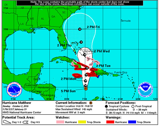
Hurricane Matthew, a powerhouse of a storm that has fluctuated from a Category 4 to Category 5 and back again in the past few days, is still forecast to make a turn and head north, threatening perhaps the entire East Coast later this week.
However, its exact path and its impacts the on the Outer Banks are still very much in question and could be for several more days.
“I want to stress…that there is still a great deal of uncertainty in the exact track and timing of Matthew,” Richard Bandy, meteorologist-in-charge of the National Weather Service office in Newport/Morehead City, said in an email this afternoon. “It is far too early to get any more specific on potential impacts than what is mentioned here. At this point, it is within the margin of error that the storm could make landfall or pass further out to sea.”
At 5 p.m., the National Hurricane Center reported that the center of Matthew was in the Caribbean several hundred miles south of both Jamaica and Haiti. The cyclone’s winds were reported at 145 mph, keeping it a strong Category 4, and it was moving northwest at 5 mph.
The Hurricane Center’s 5 p.m. discussion notes that earlier today, the hurricane meandered westward for several hours, but recent aircraft and satellite fixes indicate that the motion is northwestward, albeit slowly.
The track forecast reasoning, the Hurricane Center adds, is about the same as it has been — Matthew is expected to turn northward and move along the western side of a mid-level high pressure area for the next several days. Later in the forecast period, a ridge building slightly to the north of the tropical cyclone could induce a turn to the west.
On the forecast track, Matthew will be a major threat to Jamaica, Haiti, and eastern Cuba over the next few days, and in five days time emerge into the Atlantic in the vicinity of the Bahamas on Wednesday and be off the southeast coast north Florida or southern Georgia on Friday afternoon with winds expected to be about 105 mph.
“Although the official forecast continues to show a track east off Florida,” the Hurricane Center says, “it is still too soon to rule out possible hurricane impacts there. It is also too soon to know whether, or how, Matthew might affect the remainder of the United States East Coast.”
The local National Weather Service Office stresses that there has not been much change in the forecast track.
“While the forecast from NHC and WPC, and many of the global models are keeping the center of the storm off the coast,” Bandy said in his email, “we must remain vigilant and prepared. There are still a wide range of potential solutions regarding the track and forward speed of the storm, which will affect the impacts on our area. ”
Even if the storm remains just off the coast, Bandy added, the Outer Banks could see impacts, including strong winds, heavy rain and flash flooding, coastal flooding, and high surf with significant erosion and overwash.
“A slow moving, large powerful storm off the coast can be very dangerous,” said Drew Pearson, Dare County’s emergency management director.
Both Pearson and the National Weather Service are advising residents and visitors to make their plans now and get hurricane disaster kits ready.
Interests along the Outer Banks should keep up with the latest forecasts from the Hurricane Center and the local National Weather Service Office in Newport/Morehead City.
Meanwhile, the local Weather Service has issued a beach hazard statement for a high threat of rip currents north of Cape Hatteras tomorrow and perhaps for much of the week as Hurricane Matthew approaches. Large waves, dangerous surf, and beach erosion are also possible later in the week.
With various tropical systems hanging around offshore during September, the rip current threat has been high along the Outer Banks more days than not.
Rip currents are most likely around low tide, which is around 4 p.m. on Monday.
Beach-goers should use extreme caution if swimming in the ocean. There have been five drownings this summer — two this month — in the Cape Hatteras National Seashore, all associated with rip currents.
And the National Park Service and local rescue squads report there have been many rescues and close calls all month long.
For local weather information, go to http://www.weather.gov/mhx/. The page has links to the tropical forecast. You can find the beach forecast, including the rip current forecast on the Island Free Press home page — at the top right. Click on the icon with the beach umbrella.


