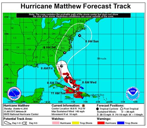
Powerful and dangerous Hurricane Matthew made landfall on southwestern Haiti this morning and is taking aim at western Cuba and the Bahamas before it is forecast to move up the southeast coast of the United States, coming near or just over the Outer Banks late Saturday or early Sunday.
The message this morning from the local National Weather Service office in Newport/Morehead City, N.C., is to take this storm seriously and get prepared. The Weather Service says Matthew is forecast to be a Category 2 hurricane that has the potential to pass across or very near to the coast of eastern North Carolina.
“Hurricane Matthew is poised to bring significant and potentially life-threatening impacts across the area,” the Weather Service said in its noon bulletin. Threats include dangerous storm surge and high surf, damaging strong winds that could produce power outages, heavy rainfall and flash flooding, tornadoes, dangerous boating conditions, and rip currents.
At 11 a.m., Matthew was still a Category 4 hurricane approaching the coast of eastern Cuba with winds at 145 mph. The National Hurricane Center said that fluctuations in intensity are possible during the next couple of days, but Matthew is expected to remain a powerful hurricane through at least Wednesday night. Some weakening is anticipated by the end of the forecast period due to an increase of the wind shear.
Matthew is moving toward the north at about 10 mph.
The hurricane is being steered by the flow around the western edge of a subtropical ridge. Most of the global models build the ridge westward, and this pattern should force the hurricane to turn toward the northwest across the Bahamas and to the waters just east of Florida. Beyond three days, the ridge is forecast to shift eastward, allowing Matthew to turn northward and then northeastward, according to the Hurricane Center.
Most of the models shows a strong hurricane near the east coast of Florida and the southeast United States from Thursday through Sunday.
The local Weather Service advises residents and visitors to eastern North Carolina not to focus on the exact center track of the storm — regardless of the track or strength, it has the potential for dangerous impacts across the area.
With a reminder that there are significant uncertainties in the track, the Weather Service offers these forecast details:
Dare and Hyde county emergency control groups have not made any announcements yet, but residents and visitors should be prepared if there is a notice to evacuate Hatteras and/or Ocracoke.
For local weather information, go to http://www.weather.gov/mhx/. The page has links to the tropical forecast. You can find the beach forecast, including the rip current forecast on the Island Free Press home page — at the top right. Click on the icon with the beach umbrella.
Click here to see the latest briefing from the National Weather Service in Newport/Morehead City.
CANCELLATIONS
Hatterasity, the bluegrass block party and festival planned for Oct. 6-8 in Hatteras village, has been postponed until a later date.
RELATED STORIES
Powerful Matthew’s impacts on Outer Banks still in question
Outer Banks is keeping an eye on Matthew


