

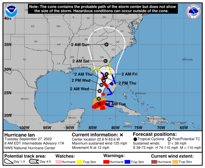
While confidence is increasing that Hurricane Ian will tack to the west of the Outer Banks, indirect impacts are still expected over the weekend from this storm, and particularly heavy rains and the potential for coastal flooding, per a Tuesday morning update from the National Weather Service Newport/Morehead City.
Ian has strengthened to a hurricane this morning, and is expected to rapidly intensify to a major hurricane in the next 24 hours as the storm heads northward into the Gulf of Mexico, and eventually to the Florida peninsula by late this week.
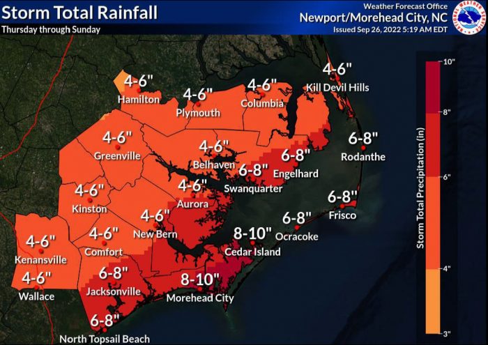
Though Ian will weaken after landfall, a combination of an offshore front and tropical moisture associated with Ian will lead to an extended period of heavy rain across Eastern N.C., and impacts are expected to start on Friday and last through much of the weekend.
As of Tuesday morning, 6-8 inches of rainfall is forecast for Hatteras and Ocracoke Islands from Thursday through Sunday, although the total amounts of rain will be highly dependent on the eventual track, which is likely to change over the next few days. There is the potential for flash flooding, as well as minor flooding of local main stem rivers, as well as smaller tributaries and creeks.
As of 8:00 a.m. on Tuesday, Ian was located about 10 miles NNE of the city of Pinar Del Rio in Cuba. The storm was moving north at 12 mph with maximum sustained winds of 125 mph.
On the forecast track, the center of Ian is expected to emerge over the southeastern Gulf of Mexico in a couple of hours, pass west of the Florida Keys later today, and approach the west coast of Florida on Wednesday and Wednesday night.
For more information on the local forecast, visit www.weather.gov/mhx for general weather information, or the National Weather Service office in Newport / Morehead City’s Facebook page at https://www.facebook.com/NWSMoreheadCity/.


