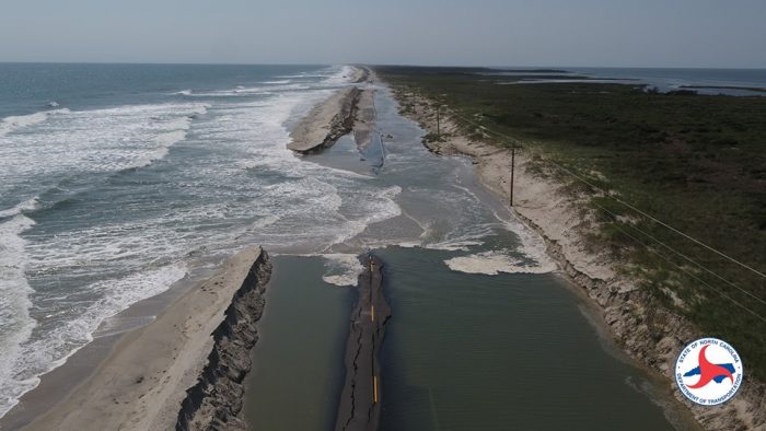
The N.C. 12 Task Force met in Manteo on Tuesday, Feb. 7, to review a subcommittee report on proposed solutions and priorities for seven vulnerable stretches of N.C. Highway 12 on Hatteras and Ocracoke Islands.
The Task Force was formed in 2021 to address the routine flooding of the 67-mile stretch of N.C. Highway 12 that extends from Oregon Inlet to Ocracoke, and to find viable solutions that could be implemented to keep the highway open for the short term and the long term.
Comprising of representatives from Dare County, Hyde County, the National Park Service, the North Carolina Department of Transportation (NCDOT), the Southern Environmental Law Center, the NC Division of Marine Fisheries, the US Fish and Wildlife Service, and additional state and federal agencies, the goal was to have all stakeholders at the table to form a long-range plan.
The N.C. 12 Task Force’s subcommittee, (with representatives from the above organizations), met in a series of meetings over a six-month period from June to December of 2021 to review each of the “hotspots” – or areas of the highway that were most susceptible to ocean and soundside flooding – and to identify the best location-specific ways forward.
Tuesday’s meeting was a review of the Highway 12 Task Force Subcommittee’s final report, which was released at the end of 2022, and County Manager and Subcommittee Chairman Bobby Outten walked through each of the seven identified hotspots, and their individual solutions.
Short-Term and Long-Term Solutions
Northern Pea Island, (aka the Canal Zone), and Pea Island Visitor Center
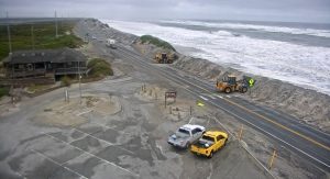
Summary: The northern portion of Hatteras Island includes a hotspot near the Basnight Bridge referred to as the “Canal Zone,” as well as a hotspot next to the Pea Island Visitor Center. NCDOT makes significant road and dune maintenance investments to maintain transportation, but despite these efforts, these areas overwash several times a year causing unsafe road conditions, transportation delays, and road closures.
Short-term: The consensus of the subcommittee was to continue the current approach of reinforcing dunes, build temporary bridges when necessary, and to consider beach nourishment as an emergency, stop-gap measure.
Long-term: For the long term, the subcommittee looked at the following alternatives: status quo maintenance, a bridge in place, a long bridge around all areas connecting Basnight Bridge to the Jug Handle Bridge, and/or a series of smaller bridges around the various hotspots in the area.
NCDOT advised that the status quo was not sustainable, and a long bridge – while preferable – was not cost-effective with an estimated price tag of roughly $1 billion dollars. As a result, the subcommittee determined that smaller bridges around the Canal Zone and Visitor Center could work, but an approximately seven-mile-long bridge starting around the southern terminus of the Basnight Bridge and continuing around the Visitor Center, (an idea that was previously proposed in an NCDOT report), might be the most feasible solution considering highway vulnerability and cost.
Rodanthe S-Curves
Summary: This hotspot north of Rodanthe, referred to as the S-Curves, is routinely exposed to regular ocean overwash, resulting in multiple closures of N.C. Highway 12 in the past.
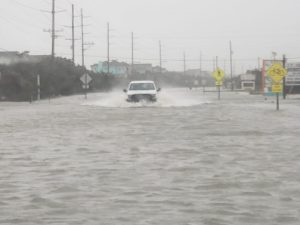
Long-term: Though the S-Curves was a noted hotspot when the N.C. 12 Task Force was formed, a long-term solution has already been implemented with the construction of the Jug Handle Bridge, which opened to traffic in the summer of 2022, and effectively bypasses the S-Curves hotspot. As a result, no further solutions are needed for this former hotspot.
Avon
Summary: The Avon hotspot begins around the Avon Pier and continues south to the end of Ocean View Drive. Recent rapid erosion, loss of dunes, and frequent ocean overwash, (sometimes combined with soundside flooding and rainfall), can result in deep flooding of N.C. Highway 12.
Short-term: For the short term, beach nourishment was seen as the only practical solution. During the summer of 2022, Dare County implemented a beach nourishment project in this area, and a maintenance beach nourishment project is expected in roughly five years.
Long-term: For the longer term, raising the road in place was considered as an option, however, this solution could create other problems with drainage and flooding of adjacent and highly-populated areas. A bridge around Avon was also not ideal, as access to the community would be affected. The consensus of the subcommittee was to consider the implementation of beach nourishment until other ideas were developed.
Buxton
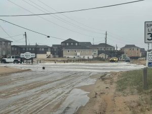
Summary: The Buxton hotspot starts on the south end of Avon village and continues to the northern portion of Buxton village. The most vulnerable area is an approximately one-mile-long section in northern Buxton between the village boundary and the jetties near the original site of the Cape Hatteras Lighthouse. The highway frequently overwashes in an area around several motels and adjacent side streets located on the northern end of the village.
Short-term: A beach nourishment project was completed in 2018 and again in 2022. Both projects met the immediate goal of protecting N.C. Highway 12 and minimizing impacts to transportation.
Long-term: For the southern end of Avon to Buxton, several long-term alternatives were considered from NCDOT’s report entitled “NC 12 Improvements from Buxton to Avon,” dated October 2015. From that report, the subcommittee favored Alternative 2, a bridge from the Haulover Beach Parking Area to the northern entrance of Buxton, and Alternative 3, a bridge from the southern boundary of Avon to Buxton’s Rocky Rollinson Road. The consensus of the subcommittee for the long term was to consider a combination of Alternatives 2 and 3; ultimately, a bridge that starts from southern Avon and ends in the center of Buxton village.
Frisco/Hatteras Village
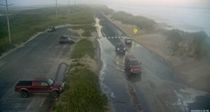
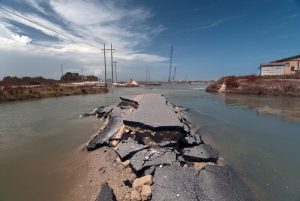
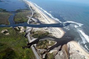
Summary: The highway between Frisco and Hatteras village is vulnerable, and particularly at a mile-long stretch just north of Hatteras village, which is routinely exposed to ocean and soundside flooding. This section of roadway was previously breached by Hurricane Isabel in 2003, when a 2,000-foot-wide and 15-foot-deep inlet temporarily formed in the area.
Short-term: With limited options, the consensus of the group was to utilize the short-term solution of beach nourishment to preserve the road. Where seepage continued to flood the road along northern Hatteras village, the group considered raising the road elevation.
Long-term: For the long haul, the subcommittee considered four alternatives.
- Alternative 1 was a road relocation to the north.
- Alternative 2 was a combination of road relocation and a 200-foot-long bridge.
- Alternative 3 was beach nourishment.
- Alternative 4 was road relocation and a beach nourishment project.
Alternative 1 was eliminated because there was insufficient land area. Alternative 3 was eliminated because it cost more than other alternatives and was less sustainable. The consensus of the subcommittee was a longer bridge hybrid of NCDOT alternatives 2 and 4, which would extend the bridge from the Frisco Bathhouse to Hatteras village, to try to avoid the hotspot area in its entirety.

Ocracoke
Summary: There are several ongoing issues on Ocracoke Island. The Hatteras-Ocracoke ferry channel has been challenging to maintain, resulting in delays and longer ferry trips. The South Dock ferry terminal on Ocracoke Island has also been difficult to maintain due to erosion, which caused a realignment of the terminal’s stacking lanes. Finally, the northernmost two-mile stretch of Ocracoke Island is rapidly eroding, resulting in regular flooding and closures of N.C. Highway 12 next to the ferry docks.
Short-term: Unfortunately, there are very few short-term solutions available for northern Ocracoke Island. For now, the consensus was to continue using the current method of holding the dock and roadway in place until a more permanent solution could be implemented.
Long-Term: The consensus of the subcommittee was to move the Hatteras-Ocracoke ferry’s South Dock to an undetermined location closer to Ocracoke village to avoid the cost of having to build a long causeway-type entrance to the ferry terminal, and to avoid having the ferry terminal located in an area that would likely be cut off from Ocracoke village. Passenger ferries were also seen as a possible way to mitigate impacts to tourism caused by longer run times and the inability to meet demand. An additional study of a landing site in the location of Ocracoke village near Silver Lake and other areas was recommended to facilitate decision-making.
Identifying Priorities
Once solutions were identified for the seven hotspots, the next step was to identify priorities
“The committee had the task of trying to prioritize [the hotspots],” said Outten. “If we had some amount of money that would allow us to do one thing tomorrow, what would we do?”
The consensus was that the Pea Island area should be addressed first, as it was the area that connected to all other regions of Hatteras and Ocracoke Islands. If a long road closure occurs in the Pea Island area, (like during Hurricane Irene in 2011), the only way on and off the island for all residents is via an emergency ferry from Rodanthe to Stumpy Point.
After that, the second priority was Hatteras/Frisco, (again, to maintain access to Hatteras village), followed by Ocracoke, although it was noted that there was not an easy or immediate solution available for northern Ocracoke’s challenges. Avon and Buxton, which currently have beach nourishment projects in place, were lower in priority as there were already temporary solutions that would be implemented, (in the form of maintenance beach nourishment projects), over the next few years.
Next Steps
Now that an outline has been created of preferred solutions and priorities, the next step for these projects is to facilitate funding, and there was some good news in this vein at Tuesday’s N.C. 12 Task Force meeting.
Thanks to federal infrastructure bills and a number of available grants, finding the funds for the transportation projects will not be as difficult as it was when the N.C. 12 Task Force was formed roughly two years ago.
“We were in dire straits two years ago, thinking ‘Where will we find the money to do bridges?’ So maybe it’s a Godsend that we had to go through this process,” said N.C. 12 Task Force Chairman Bob Woodard. “I wanted this Task Force to try to address this, so we can come to some agreement about what kind of actions that we can take from the subcommittee’s report, and try to [identify] and fund the long-term goals of N.C. Highway 12.”
“Now it’s time for us to go to work and try to find ways to find money to make these long-term solutions come together.”
The N.C. 12 Task Force arguably has a head start on obtaining funds from various channels, because of the committee’s make-up of varied stakeholders.
From the National Park Service, to the NCDOT, to roughly a dozen other federal, state, and local organizations with an interest in keeping N.C. Highway 12 open, the wide representation of members means a wider network of funding opportunities.
Woodard noted that county representatives were meeting with the North Carolina Legislature to start the conversation on Wednesday, and other N.C. 12 Task Force Members – like David Hallac of the National Park Service – also stated that they had started to investigate funding opportunities as well.
One specific source of funding that was discussed at Tuesday’s meeting was the FHWA PROTECT Program. The recently passed Bipartisan Infrastructure Law established a new Federal Highway Administration (FHWA) program to help address the ability of transportation systems to respond to current and future weather events and natural disasters.
North Carolina can expect to receive an estimated $194,421,690 over the course of five years as a result of the PROTECT Program, but the challenge for the N.C. 12 Task Force is ensuring that these funds are directed to N.C. Highway 12. There are concerns that rather than using the money for resilience projects, like those needed on the Outer Banks, the money may be used instead to widen existing evacuation routes, or address other projects in the state.
“The Park Service, in collaboration with the Fish and Wildlife Service… has identified this PROTECT funding as potential funding that could fund all three priority transportation solutions,” said National Parks of Eastern North Carolina Superintendent David Hallac. “And we’re going to work as hard as we can with all the partners at the table here to see if we can bring some of that money to [fix] these problems.”
Obtaining funds for any of the projects is not guaranteed, but the N.C. 12 Task Force was optimistic at the end of Tuesday’s meeting, having a strategy in place, and many more funding options available than when the Task Force was formed in 2021.
No future meetings of the N.C. 12 Task Force are currently scheduled, however, the Task Force has not disbanded, and will be in contact in the months to come as funding avenues are explored.
For More Information
To view the entire Highway 12 Task Force Subcommittee’s report, click here.
For more information on the N.C. 12 Task Force, including details on the seven individual hotspots, visit the Dare County Website.


