

N.C. Highway 12 is open and passable after Tuesday afternoon’s approximate 4:00 p.m. high tide, however, some blowing sand and foam were reported on the roadway in multiple spots along Hatteras and Ocracoke Islands, and caution is advised.
The prolonged period of gale-force northerly winds will continue through Wednesday morning, with gusts up to 45-50 mph. Coastal flooding of 2-3 feet above ground level will remain possible through Thursday morning, per an update from the National Weather Service Newport/Morehead City office.

Rough surf and minor to locally-moderate beach erosion are expected from Duck to Cape Hatteras, (along with localized ocean overwash), and N.C. Highway 12 is still at risk of being impacted, especially during the next three high tide cycles.
The next high tide is approximately 5:00 a.m. on Wednesday, February 7.
Minor soundside flooding, (with inundation of 1-2 ft. above ground level), is also forecast along areas adjacent to the southern Pamlico Sound, and minor soundside flooding was reported in Ocracoke Village as of Tuesday afternoon.
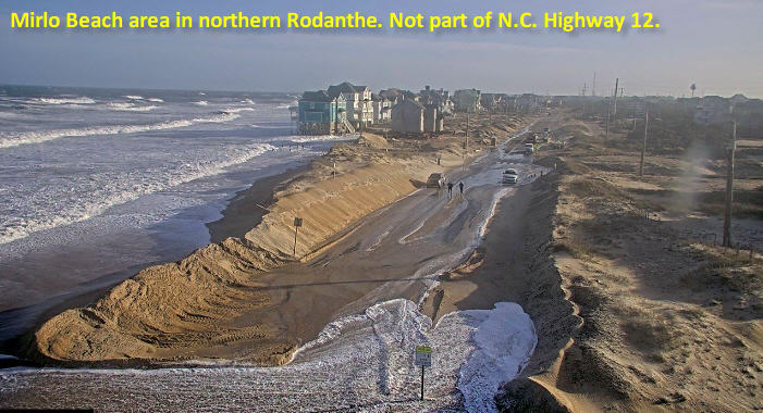
Oceanside flooding that impacted the secondary roads of northern Rodanthe – an area that is now bypassed by the Jug Handle Bridge – was reported throughout the day on Tuesday. The North Carolina Department of Transportation (NCDOT) has crews in the area clearing these secondary roads and building a protective berm, but visitors in northern Rodanthe should use caution and avoid flooded roads unless necessary.
A Coastal Flood Warning remains in effect until 8:00 a.m. on Thursday, while a High Surf Advisory is in effect until 7:00 a.m. on Friday, and a High Wind Advisory is in effect until 7:00 a.m. on Wednesday.
The Hatteras-Ocracoke, Ocracoke-Swan Quarter, and Ocracoke-Cedar Island ferry operations are suspended as of Tuesday morning, February 6, due to the high winds and weather conditions.
To get notified of ferry delays or cancellations, sign up for text and/or email alerts via the N.C. Ferry System’s FINS system: www.ncdot.gov/fins. The public can also see updates on all three Ocracoke Island routes via the Ferry Division’s social media accounts at https://twitter.com/NCFerryHatteras/ and https://twitter.com/ncferrypamsound/.
For more information on the local forecast, visit www.weather.gov/mhx for weather information, or the National Weather Service office in Newport/Morehead City’s Facebook page at https://www.facebook.com/NWSMoreheadCity/.


