When most people hear the word “tsunami,” they likely think of a seismic tsunami – one caused by an earthquake or underwater volcano, and an image of a giant wall of water rushing toward the shore may come to mind.
But not all tsunamis are quite so dramatic. Some tsunamis can be triggered by atmospheric conditions and weather. These are called “meteotsunamis.” And while they may not pack the same punch for destruction as their seismic counterparts, meteotsunamis may be having a big impact on coastlines all along the East Coast.
A group of National Oceanic and Atmospheric Administration scientists have been investigating these wave events, and Gregory Dusek, a senior scientist with NOAA and lead author on a meteotsunami study published last month, said knowing more about these waves will help better understand potential contributors to flooding and inundation.
“This is a component of storms that has generally not been looked at – when you start thinking about understanding storm surge and potential impacts,” Dusek said. “Can we better understand why (meteotsunamis) occurred during tropical storms or winter storms, and how much are they potentially contributing toward flooding? Do we need to start including some component of this in our (weather) modeling?”
According to NOAA press release, meteotsunamis are generally small – less than 1.5 feet tall – and weather-driven, set off by air pressure change from fast-moving severe thunderstorms, tropical storms and squalls. They occur all over the world, even in the Great Lakes, though the East Coast sees an average of about 25 a year.

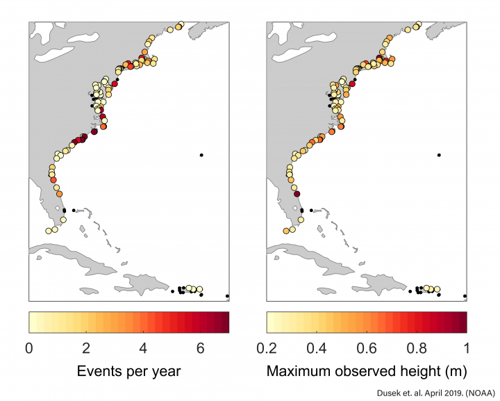
Scientists looked at the water level records between 1996-2017 from 125 tide gauges along the eastern seaboard and found nearly 550 meteotsunamis had occurred in that 22-year period, including one during Hurricane Irma in 2017. They found meteotsunamis occur most often in the Carolinas, northern Florida and Long Island Sound, with the largest waves found in areas where estuaries or the shape of the coastline has amplified them.
According to the press release, Myrtle Beach, South Carolina, and Duck, North Carolina, observed the greatest number of events: 148 or 7.2 per year; and 130 or 6.0 per year, respectively. Wrightsville Beach and Cape Hatteras had the highest averages per year – 8.7 per year and 8.9 per year, respectively – for any station with at least five years of data.
Cape Hatteras also saw one of the larger events recorded. Dusek said in February 1998, a meteotsunami of about 3 feet was recorded at the fishing pier, presumably caused by a winter storm.
“The event was recorded in Cape Hatteras and then also in Beaufort and at Springmaid Pier, which is Myrtle Beach, so it was observed in southern North Carolina into South Carolina,” Dusek said. “I’m not exactly sure on the characteristics of why that specific event occurred, but it was fairly substantial. It would be interesting to know if that was observed by anyone or if it caused any damage.”
The largest events recorded included a roughly 3.5-foot wave at Providence, Rhode Island, in December 2005 and a nearly 4-foot wave in Port Canaveral, Florida, in June 1996, according to the report.
While most are less than 1.5 feet in height, some are large enough to cause some injuries and destruction. The study cites one such incident in Barnegat Inlet in New Jersey in June 2013, when a series of large waves sent a group of divers over a breakwater and crashed into a jetty, knocking people into the water and causing property damage.
Dusek said there have been others instances of injury or property damage in Maine, the Great Lakes and on the coast of the Mediterranean, which it’s another good reason to monitor meteotsunamis.
“I would say that injury cases are the extreme events, but we have had a few of those. So I think we want to make sure that we are prepared for the potential extreme events,” he said.

Making Bad Weather Worse
While there are exceptions to the rule, typical meteotsunamis often go unnoticed because of their size. Dusek said there have been eyewitness accounts of water receding, similar to what might be seen ahead of a large seismic tsunami, but most people may not recognize a meteotsunami unless they really knew what they were looking for. He explained that just like in a seismic tsunami, there could be multiple waves in a meteotsunami traveling 30 minutes to an hour or more apart, depending on conditions.
“I think in most cases, especially when you think the kind of open beach areas along most of the North Carolina coast where you open shoreline, unless you are on the beach you probably wouldn’t notice (a meteotsunami),” Dusek said. “You’re probably not going to notice a 1- to 2-foot rise in water level in most cases.”
A 1- to 2-foot wave might not seem like much on its own, but “if it’s coupled with tropical storms or winter storms, it might increase (beach) erosion or flooding if you have a meteotsunami at the same time,” Dusek said.
“The challenge we have with some of these (meteotsunamis) is that if they occur during a winter storm or during a tropical storm, that storm might already be causing a lot of damage, or an increase in water level,” he said. “So the meteotsunami is probably not the primary reason why you might have flooding or something, but it can contribute to it.”
“… a lot of times these meteotsunamis are going to be created in conjunction with land-falling hurricanes, for instance, and other types of storms that maybe are moving toward the coast …”
— Michael Angove, National Weather Service
Michael Angove, tsunami program manager for the National Weather Service, agreed. The National Weather Service is interested in the meteotsunami research because it could help with forecasting such events.
Angove said the June 2013 meteotsunami in New Jersey caught the attention of scientists because the system of storms that triggered it had moved from the upper Midwest and across the mid-Atlantic before heading offshore, where it triggered meteotsunami wave.
“It hit our tsunami sensor … off of New York state, and it was a pretty strong hit,” he said. “That was really when we looked at this data and said, ‘We have to treat these more rigorously like we would other types of hazards.’ It’s really what got the ball rolling in terms of going back and looking at the data and trying to make sense of it – if it’s something we could potentially issue forecast warnings on.”
He noted that meteotsunamis are not likely to be stand-alone events that could pose a threat to the public on the North Carolina coast.
“But a lot of times these meteotsunamis are going to be created in conjunction with land-falling hurricanes, for instance, and other types of storms that maybe are moving toward the coast – and therefore (a meteotsunami is) going to be kind of incorporated in this broader bad weather,” Angove said.
In such a case, he said the local forecast office might issue a special weather statement saying in addition to strong storm surge, wind waves and rain, conditions may be favorable to create a “shallow water long wave” that could add to any expected coastal inundation.
“Along the North Carolina coast, it’s something that can at certain times make bad weather worse,” he said.
Looking ahead, Dusek said the next steps in meteotsunami research are to create computer modeling and numerical modeling.
“That will help give us a better look at how these events are created, how they move and how they might affect locations that are away from the tide gauges,” Dusek said. “It’s quite possible that in many cases we don’t observe the largest of an event – a wave might only be a couple of feet at our gauge but maybe it’s larger somewhere else because we’re only observing it at that one point.”
Dusek said his group will also continue to work with the National Weather Service.
“We’re collaborating with them on trying to get them this information because before you can better understand events and when to expect them, you’ve got to know when they have occurred in the past,” he said. “So this (study) was kind of the first step just to better establish when you might be concerned with events.”


