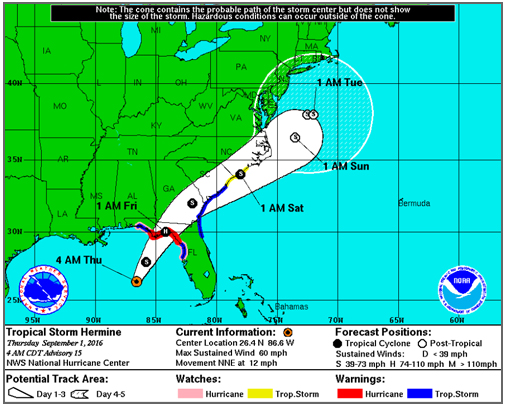
Overnight, the track of Tropical Storm Hermine has shifted again — this time back toward the Outer Banks.
As of the 8 a.m. update, Hermine was in the Gulf of Mexico with winds increased to 65 mph, headed north-northeast at about 12 mph. This track, with a slight increase in forward speed, is expected for the next day or so.
On this track, the National Hurricane Center says the storm will reach the Big Bend area of northern Florida tonight or early Friday. The winds are expected to strengthen, and the storm is expected to be a hurricane at landfall.
After making landfall in Florida, Hermine is forecast to move across that state, into Georgia and South Carolina and then skirt the coast as it moves northeast, passing just off the Outer Banks.
“Do not focus on the center track,” the local National Weather Service office in Newport/Morehead City, said in its morning briefing. “The entire area will experience minor to some moderate impacts from Hermine. Minor track changes will result in very different impacts for specific locations, especially regarding potential storm surge.”
Also, this morning, local forecasters noted that the projected movement of the storm after it makes landfall in Florida has slowed, slightly delaying both the onset and ending of the most significant impact on the Outer Banks.
However, the delay in winds is not expected to be too great, since the size of the wind field has expanded a bit.
The Weather Service says the area remains under a “significant rainfall threat.
“Regardless of the exact track, ample amounts of moisture will be streaming over the area with heavy rains likely for an extended period,” the NWS said.
Rainfall could begin as early as tonight and continue into the day on Saturday, ending sometime Saturday evening. Widespread 5- to 8-inch rainfall amounts are forecast with possible isolated amounts to 10 inches. The rainfall will likely result in flash flooding.
There is also a threat of isolated tornadoes for the area.
At least minimal tropical storm force winds of 40 mph are possible across the entire area, and seas are likely to be at least 12 to 16 feet. The strongest sustained winds will be Friday night through Saturday, lingering into early Saturday night across the Outer Banks.
The threat of coastal flooding and beach erosion continues. All coastal areas, the Weather Service says can expect minor soundside flooding at least a foot above ground level in low lying areas. Some areas may receive moderate flooding of up to 2 feet above ground level.
However, forecasters say that because of the wavering track of the storm, it’s too early to indentify specific areas at the greatest risk.
There will also be water level rises on the ocean side with large waves, resulting in at least minor beach erosion.
A high risk of rip currents will continue through the weekend, and dangerous shore break remains a concern south of Cape Hatteras.
To keep up with the latest local forecast, go to www.weather.gov/mhx/.
Click here for the latest local NWS briefing on Tropical Storm Hermine.
RELATED STORIES
Second tropical system in a week forecast for Hatteras, Ocracoke


