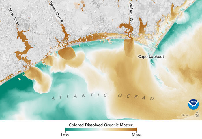
An aerial image recently taken by a NASA satellite shows how excessive flooding may be impacting sound and ocean waters all along the coast of North Carolina.
Captured on September 19, the satellite image shows how the inland flooding has affected water quality in the White Oak River, New River, Adams Creek, as well as their subsequent outflows along the coastline. Per NASA, “the natural color image from Landsat 8 reveals how soils, sediments, decaying leaves, pollution, and other debris have discolored the water in the swollen rivers, bays, estuaries, and the nearshore ocean.”
The National Weather Service office in Raleigh provided a preliminary estimate that nearly eight trillion gallons of rain fell on North Carolina from Sept 13 to 17, 2018. This was one of several factors, along with storm surge, which led to catastrophic flooding across many southwestern parts of the state.
Per NASA, the Trent River reached an all-time high of 29 feet on September 17, which is more than twice the flood stage, or the height at which the river will overflow and cause damage. The Trent was one of 16 rivers that reached major flood stage in North Carolina on September 18, and while the majority of the rivers have started to subside, many still remain in major flooding stage.
Locally, on September 24, state officials announced that bacteria levels at swimming sites in Dare and Currituck counties meet state and Environmental Protection Agency standards for swimming and other contact with the water.
The N.C. Recreational Water Quality Program reported that they had tested all established swimming sites in Dare and Currituck counties and found that bacteria levels fall with the state’s and Environmental Protection Agency’s standards set for swimming and water play.
The Recreational Water Quality Program has been unable to test waters in other coastal counties due to the impacts from Hurricane Florence.
The Program states that it will begin testing in other coastal areas as soon as conditions are safe to do so, the areas are accessible, and testing equipment is functional. Current advisories will be lifted in part or in whole as these test results become available.
“Excessive rains and flooding can cause high levels of bacteria in the water that can make people sick,” stated the Recreational Water Quality Program in a press release. “Floodwaters and storm water runoff can contain pollutants such as waste from septic systems, sewer line breaks, pet waste, wildlife, petroleum products and other chemicals.”
A precautionary water quality advisory remains in effect for all other coastal counties besides Dare and Currituck, which includes Hyde County. Residents and visitors, including fishermen, who cannot avoid contacting those waters should exercise caution, limit wound exposure, and thoroughly wash their hands.
Recreational water quality officials sample 209 sites throughout the coastal region, most of them on a weekly basis from April to October. Testing continues on a reduced schedule during the rest of the year, when waters are colder.
For more information about coastal recreational water quality and to see current alerts, visit http://portal.ncdenr.org/web/mf/testing-site.


