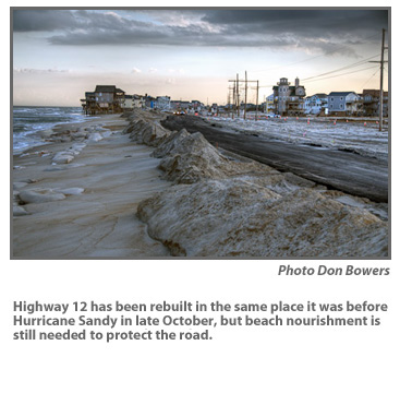
Now that Highway 12 has reopened north of Rodanthe, transportation officials will be keeping a close eye on the sandbags that hold back a surging ocean, as plans are being made to widen the beach.
The beach at the S-curves is nearly non-existent and the sandbags protecting the highway stand at the edge of the surf.
Besides monitoring and maintaining the sandbags, there’s little else the North Carolina Department of Transportation can do while details are worked out by the U.S. Army Corps of Engineers to get the beach widened.
“I’ve crossed all my fingers and toes,” said Victor Barbour, DOT technical services administrator.
The highway at the S-curves was damaged by Hurricane Sandy in October and two northeasters in November.
DOT had two choices for replacing the road, according to Jerry Jennings, DOT’s District 1 engineer.
The first was to replace it where it was before the storm, which he said last month would require beach nourishment because of the erosion caused by the battering seas.
The second option was to move the road to the west – out of the right-of-way and onto Pea Island National Wildlife Refuge land. That option would require a lengthy permitting process.
DOT chose to go with the first option replacing the road in the existing right of way, and repair work was finished yesterday, Dec. 19.
However, the ocean is still right at the edge of the highway at high tide as nourishment is being pursued by both DOT and the U.S. Army Corps of Engineers.
Barbour said that engineering work is being done to determine what sort of beach nourishment project is feasible to use as a temporary measure until a permanent solution is in place. The DOT is expected to announce the chosen long-term alternative for Rodanthe in March.
Separately from this “emergency” nourishment at the S-curves, Dare County is investigating ways to fund its own beach nourishment projects at Rodanthe and Buxton as a permanent solution, similar to what the town of Nags Head did with its recent beach widening project.
Since the beach is mostly gone north of the Rodanthe Pier, said Dare County manager Bobby Outten, he does not believe that the federal government’s policy against beach nourishment would apply.
“I suppose as the process goes on,” he said, “that will be determined — whether the Park Service has any say-so over what we do.”
If the county does decide to do beach nourishment, Outten said, it would take at least “a couple of years” before the project would be ready to go out for proposals.
Barbour also said that the DOT expects to “work though” any policy issues on beach nourishment with the National Park Service and the U.S. Fish and Wildlife Service.
Bob Keistler, project manager for the U.S. Army Corps of Engineers, said that the agency is waiting for funds to be finalized by the state Department of Transportation, which are being provided mostly by the Federal Highway Administration from its Hurricane Sandy emergency funds.
Cost estimates can’t be released before a contract bid is accepted, he said.
Keistler said the Corps is working to identify sand sources and is coordinating with the National Park Service and the U.S. Fish and Wildlife Service. Planning is still in the preliminary stages, he said, but it appears that a nourishment project is being seriously pursued.
“I have not heard anything other than us moving forward,” Keistler said this week.
“Our plan is to put out three possible solutions — pros and cons, cost and schedule — and allow the DOT to decide what direction they want to go.”
The compatibility of the sand is crucial in meeting the permitting requirement of the Pea Island refuge, which has been cooperating with the DOT in restoration of the road.
Coastal experts have questioned the availability of offshore sand in the volume necessary at S-curves, which has the highest beach erosion rate on the Outer Banks.
Last December, the DOT removed beach nourishment as an alternative to fix Highway 12, citing high costs and the difficulty of finding sand.
Keistler said that he expects the Corps will have further details available in January.
Allen Burrus, Dare County commissioner from Hatteras village, said that he understands that an agreement between NCDOT and the Corps to do emergency nourishment at the S-Curves is currently languishing at the Office of Management and Budget in Washington, D.C.
Burrus was one of several Dare officials who traveled to Washington last week to confer with the state’s congressional delegation. Staffers seem to believe, he said, that the memorandum of understanding has been delayed by a backlog in paperwork, not political issues.
County officials, Burrus said, would like the Corps to use the sand from the channel at Oregon Inlet, which has once again became clogged with sand since the October hurricane and the northeasters that followed.


