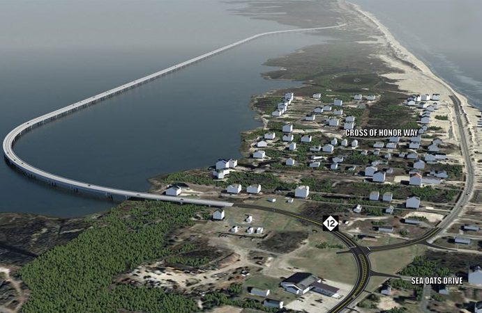
A federal appeals court dismissed an appeal by a group of Rodanthe property owners to halt the construction of the 2.4-mile Jug Handle Bridge on January 23, upholding a 2018 lower court ruling to allow construction of the bridge to move forward.
The Fourth Circuit Court of Appeals sided with the North Carolina Department of Transportation, Defenders of Wildlife, and the National Wildlife Refuge Association in a case brought by the Rodanthe group, known as Save Our Sound OBX, which argued that the state and federal agencies responsible for the new bridge failed to consider alternatives, and did not adequately assess the effects on the local environment. The group also stated that the Jug Handle Bridge could disturb a shipwreck in the area – the Pappy’s Lane Wreck – which is eligible for listing on the National Register of Historic Places, and which is believed to be a World War II assault vessel.
After the case was argued on December 11, 2018, the three-judge panel stated in their decision that the agencies involved in the bridge had complied with federal environmental laws through the 2016 “environmental assessment,” after the final bridge option was selected. The complete ruling can be found online at http://www.ca4.uscourts.gov/opinions/181649.P.pdf.
Save Our Sound OBX can still appeal to the U.S. Supreme Court.
The 2017 lawsuit was originally filed by Save Our Sound OBX Inc. and six individual plaintiffs against the NCDOT and the Federal Highway Administration, and argued that the bridge’s Record of Decision – the final step in the review process – was unlawful because the required extensive environmental review was not done. NCDOT was soon joined in defending the construction of the bridge by the Defenders of Wildlife and the National Wildlife Refuge Association, which were represented by the Southern Environmental Law Center (SELC).
The two groups, represented by the SELC, had previously sued NCDOT to try to stop the replacement of the Bonner Bridge and other N.C. Highway 12 projects before the Bonner Bridge project officially broke ground in 2016. The environmental groups and NCDOT and the Federal Highway Administration reached a settlement on this lawsuit in June of 2015.
Part of that 2015 settlement included NCDOT identifying the bridge out into the sound, (the Jug Handle Bridge), as its preferred alternative in north Rodanthe, and asking the merger team – a group of state and federal agencies involved with studying and permitting the bridges – to make it the selected alternative. In multiple public comment sessions and studies, the Jug Handle Bridge was also identified as a preferred option over several previous proposals, which included a 17-mile long bridge that was too costly, and an elevated bridge that followed the current path of N.C. Highway 12, but which was deemed an eyesore by public commenters, and which was dropped by the NCDOT due to its exposure to ocean flooding.
The project was first proposed in response to severe beach erosion at the “S-Curves” in north Rodanthe, particularly after Hurricane Irene in 2011 and Hurricane Sandy in 2012.
Staging and initial construction for the project began over the summer of 2018, with sites set up at the northern and southern terminuses of the bridge to allow for the project to begin in earnest. An approximate 3,500-foot section of N.C. Highway 12 just north of Rodanthe and the S-Curves is currently being shifted roughly 20 to 30 feet to the east to make way for upcoming construction on the new Jug Handle Bridge.
The Jug Handle Bridge is slated to be open to traffic by late 2020.


I always wondered and have posed the idea that a raised highway like that in the Florida Keys would alleviate all the environmental concerns, the NCDOT concerns of overwash, the islanders concerns for access, the power companies concern of protected power lines, the business owners concerns of lost business and yet not one official even broached the option.
Because the criminal environmental lawyers (SELC) do not want the public having access to the man-made Pea Island Wildlife Refuge. Now the plan of DOT is a 13 mile causeway to bypass all of Pea Island. The jug-handle bridge and the recently completed small bridge to the north is the beginning of the ‘long bridge’.
The plan is to have private tram tours of Pea Island.
Part of the settlement was that the Bonner replacement would be constructed so it could be tied into a bridge going down the sound and the bridge now at Pea Island would be a temporary bridge, which it is, with final solution likely to be another jug handle at Pea Island tying into the S-Curve jug handle. Little doubt then comes a bridge from Bonner replacement to a jughandle at Pea Island.
BTW the last I knew the intersection with current NC12 in Rodanthe was going to be a round-a-bout. But all the pictures recently here show a T.
Has it changed or are pictures just old?
Here is the latest I found on NCDOT site
https://www.ncdot.gov/projects/nc-12-rodanthe/Documents/modification-roundabout-0417.pdf