
Dare County provided the following updates on the 2022 Avon and Buxton beach nourishment projects as of Monday, July 19. Details on the progress of both projects are below.
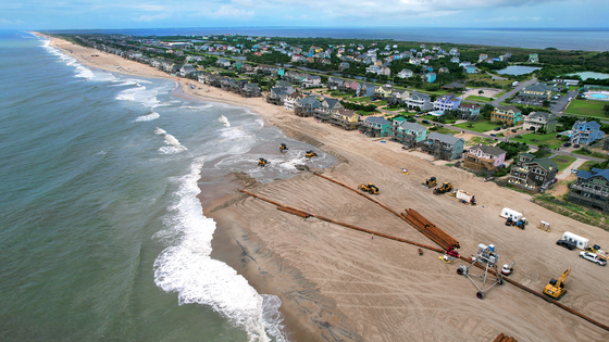
Avon Beach Nourishment:
Great Lakes Dredge & Dock Co. has announced that it continued to make significant progress on the Avon beach nourishment project over the weekend. From Saturday, July 16, through Sunday, July 17, the dredge Liberty Island placed over 90,000 cubic yards of sand along the shoreline south of the Avon Pier to nourish another 800 feet of the oceanfront.
On Monday, July 18, pumping continued to proceed south along the oceanfront fronting Ocean View Drive. Construction will continue to progress south to tie in with the nourished section of the beach near Pampas Drive to complete the final approximately 2,200 feet of the Avon beach nourishment project.
Click here to view the Avon project progress map, which shows areas of the shoreline where beach nourishment has already been completed as well as areas that are currently under construction.
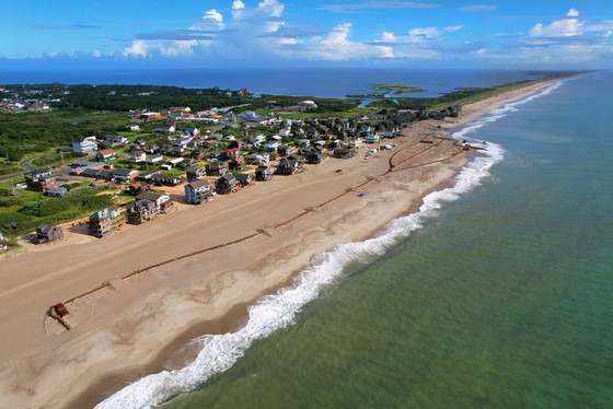
Buxton Beach Nourishment:
Great Lakes Dredge & Dock Co. also made steady progress on the Buxton beach renourishment project over the weekend. From Saturday, July 16, through Sunday, July 17, the dredge Ellis Island nourished approximately 700 feet of shoreline.
On Monday, July 18, pumping continued to proceed north along the oceanfront near Cottage Avenue. As designed, a frontal dune was built, and exposed sandbags were covered along the nourished section of the beach.
Sand ramps with gentler slopes on the landward side of the new dune were formed at several places per the permit requirements designed to protect sea turtles that may nest in the area.
Construction will continue to progress north from the current landing point near the south end of Tower Circle to the northern limit of the Village of Buxton.
Click here to view the Buxton project map, which shows the section of shoreline where beach nourishment is currently underway, as well as areas that are closed for the staging of construction equipment.
ORV Ramp 38 Reminder:
Throughout this summer, Cape Hatteras National Seashore’s off-road vehicle (ORV) Ramp 38 will remain open, but visitors with beach driving permits can expect some intermittent, short-term delays entering and exiting the ramp as beach nourishment equipment is moved safely to and from the beach.
Although the ramp will remain open, the parking lot at ORV Ramp 38 will be closed this summer. Visitors who planned to park in the parking lot at ORV Ramp 38 should instead consider using nearby parking lots at Haulover Sound Access and Kite Point Sound Access.


