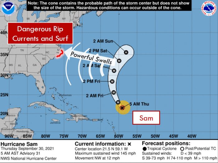
Despite Hurricane Sam remaining well out to sea this weekend, large swells created by the category 4 storm will create dangerous and life-threatening rip currents and shore break, per a recent update from the National Weather Service Newport / Morehead City office.
Some increase in swells will start to occur on Friday, but the most dangerous conditions on the Outer Banks beaches will be Saturday and possibly Sunday.
As of 8:00 a.m. on Thursday, September 30, the eye of Hurricane Sam was located about 775 miles southeast of Bermuda. Sam is moving toward the northwest near 12 mph (19 km/h), and this general motion with an increase in forward speed is expected through tonight. A turn toward the north is anticipated by late Friday, and a northeastward motion is forecast to begin on Saturday.
On the forecast track, the core of Sam will pass well to the northeast of the northern Leeward Islands this morning, and pass to the east of Bermuda early Saturday.
Maximum sustained winds are near 145 mph (230 km/h) with higher gusts. Some fluctuations in intensity are expected during the next couple of days, but Sam is forecast to remain a major hurricane through Saturday, with more significant weakening anticipated later in the weekend.
The public should check surf and swimming conditions before heading to the beach, and the daily beach forecast at www.weather.gov/beach/mhx includes rip current risk levels, and information about other hazards along the beach. In addition, visitors are encouraged to sign up for text alerts from Dare County, ocean rescue agencies, and the National Weather Service by texting “OBXBeachConditions” to 77295.
For more information on the local forecast, visit www.weather.gov/mhx for general weather information, or the National Weather Service office in Newport / Morehead City’s Facebook page at https://www.facebook.com/NWSMoreheadCity/.


