(North Carolina Department of Health and Human Services)
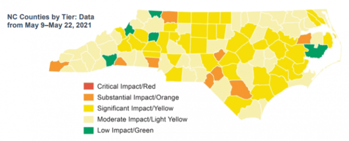
The North Carolina Department of Health and Human Services’ (NCDHHS) new COVID-19 County Alert Map update from May 27 tells the story of the ongoing substantial progress in reducing COVID transmission in the state.
By way of comparison, back in late December, about two-thirds of the state’s counties (65) were coded red for critical spread of COVID-19.
In the newest May 27 model, Dare County is coded as yellow for significant spread. Currituck County is coded light yellow for moderate spread and Hyde County is categorized as green, which represents low community spread of the virus.
In its last weekly update of COVID transmission, released on May 25, the Dare County Department of Health and Human Services reported a relatively low 21 cases in the week from May 18-24, but an increase in the percentage of positive test results to a less-than-ideal 6.77%.
In the new map, none of the state’s 100 counties are coded red, which stands for critical community spread; 9 counties are coded in orange (substantial spread); 41 counties are yellow (significant spread); 45 are light yellow (moderate spread); and 5 counties are colored green, (low community spread).
Since the previous map update on May 13, almost half (41) of North Carolina’s counties have dropped down a tier toward lower spread of the virus while only 4 have moved upward toward more transmission.
The NCDHHS’ color coding of counties is based on the rate of cases per population in the past two weeks, the percentage of positive COVID tests in the past two weeks, and “hospital impact,” which includes COVID-related cases and visits along with hospital capacity.


