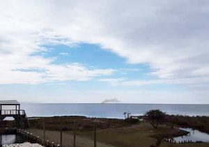
A prescribed and intentionally scheduled burn at the Dare County Bombing Range garnered attention form northern Hatteras Island residents on Tuesday afternoon, as smoke from the Dare County mainland fire was clearly visible across the Pamlico Sound roughly 20-25 miles away.
Per the Alligator River National Wildlife Refuge, (which also schedules prescribed burns at its own refuge site bordering the range), the smoke was due to a burn that was conducted by the North Carolina Forest Service in conjunction with the bombing range, which is located in mainland Dare County.
Prescribed burns in remote locales like the local Outer Banks refuges and the mainland bombing range serve a wide range of purposes, depending on the time of year. One essential purpose is to provide protection against wildfires, which can spread quickly in heavily wooded or overgrown areas. An April 2016 wildfire which affected the Dare Bombing Range, the Alligator River National Wildlife Refuge, and N.C. Wildlife Resources Commission game land on mainland Dare and Hyde counties charred more than 14,000 acres due to low humidity and high winds in the 10-20 mph range.
The Dare County Bombing Range is the primary training range for F-15E aircraft crews from Seymour Johnson Air Force Base and is the primary backyard range for F/A-18 squadrons operating out of Naval Air Station Oceana, per the U.S. Air Force, which shares the site with the U.S. Navy. The Dare County range encompasses 46,000 acres of marshlands, woods, and open space.
Prescribed burns are also seasonally conducted in the Pea Island National Wildlife Refuge, (particularly in the spring and fall), to create “safe zones” to protect villages from potential wildfires, as well as to clear out invasive vegetation, and promote fresh green growth.


