Bertha will bring large swell,rip currents to Outer Banks
Tropical Storm Bertha quickly intensified and became the second hurricane of the Atlantic season this morning. The good news for the Outer Banks is that the storm will stay well offshore, passing between Cape Hatteras and Bermuda tomorrow into early Wednesday.
At 5 p.m., Bertha was a Category 1 hurricane with winds of 75 mph — down from 80 mph earlier in the day. It is expected to make its closest pass to the coast tomorrow afternoon or evening as a 75 mph storm.
The hurricane will bring a large swell to the coast, which is great for surfers, but it is also expected to bring an elevated risk of rip currents — not such good news for visitors who are looking forward to returning to the beach after four straight cloudy, soggy days.
Meteorologist Chris Collins, says The National Weather Service in Newport, N.C., is forecasting seas of 6 to 9 feet, peaking tomorrow afternoon.
A small craft advisory is in effect for coastal waters from Oregon Inlet to Ocracoke Inlet from 2 a.m. Tuesday until 5 a.m. Wednesday.
The Weather Service also warns that there will be a high threat of life-threatening rip currents along area beaches tomorrow that could last into Wednesday.
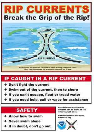
Rip currents are powerful, channeled currents of water flowing away from shore. They typically extend from the shoreline, through the surf zone, and past the line of breaking waves. Rip currents can occur at any beach with breaking waves, and are especially prevalent around two hours before until two hours after low tide.
Beachgoers should be especially vigilant about rip currents. Tips about spotting rip currents and escaping them can be found in the graphic on this page. More information is available on the Weather Service website at http://www.erh.noaa.gov/mhx/RipHazard.html.
Meanwhile, Scott Busbey, owner of Natural Art Surf Shop in Buxton, says the surfers are watching and waiting for Bertha’s swell. He said there hasn’t been much swell at all this summer, so the surfers are especially looking forward to tomorrow.
“There will be plenty of people here,” he said. “They are coming from all over.”
Busbey added that the swell will probably do a quick “in and out.” Indeed, SwellInfo (www.swellinfo.com) predicts the waves will be highest between 1 and 5 p.m. tomorrow and will peak at 8.1 feet about 2 o’clock.
The soggy weekend on Hatteras and Ocracoke was caused by a stalled frontal boundary and abundant tropical moisture that kept showers and thunderstorms along the coast from early Friday into this evening.
Rainfall began early Friday and, with only a few shorts breaks, continued into this evening.
Rainfall through 8 a.m. this morning totaled 4.19 inches at Billy Mitchell Airport in Frisco, and 3.16 inches on Ocracoke through midnight last night. Collins said there could have been locally higher amounts.
A flood watch continues into tonight with more showers expected overnight. Rainfall tapers off tomorrow with only a 50 percent chance of showers and temperatures in the mid-80s.


