Coastal Flood Advisory issued for the Outer Banks due to Hurricane Paulette
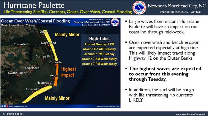
Increasing swell from Hurricane Paulette will likely cause ocean overwash on N.C. Highway 12 in vulnerable locations, starting with the next high tide cycle on Monday evening and continuing again on Tuesday morning, per a Monday afternoon update from the National Weather Service (NWS) Newport / Morehead City office.
The highest impacts are expected along the east-facing beaches from Rodanthe to Buxton. Travelers should especially use caution in local hotspots on this stretch of Hatteras Island, and specifically in northern Buxton, northern Rodanthe, and the Ocean View Drive area of Avon.
The highest waves from Hurricane Paulette are expected to occur from this evening through Tuesday, and the next high tide is at approximately 6:00 p.m. on Monday. As of 3:00 p.m. on Monday, N.C. Highway 12 was clear and free of flooding throughout Hatteras and Ocracoke islands.
In addition, a high risk of life-threatening rip currents remains in effect, and is expected to continue over the next several days.
As of 2:00 p.m. on Monday, the eye of Hurricane Paulette was located near latitude 33.9 North, longitude 64.4 West, or about 115 miles north of Bermuda. Paulette is moving toward the north-northeast near 13 mph (20 km/h), and this general motion should continue into the early evening hours.
A turn toward the northeast is expected later tonight followed by a turn toward the east-northeast, and an increase in forward speed Tuesday night through Thursday.
Maximum sustained winds have increased to near 105 mph (170 km/h) with higher gusts. Additional strengthening is likely through Tuesday night as Paulette accelerates northeastward to east-northeastward. Gradual weakening is forecast to begin on Wednesday.
For more information on the local forecast, visit www.weather.gov/mhx for weather information, or the National Weather Service office in Newport / Morehead City’s Facebook page at https://www.facebook.com/NWSMoreheadCity/.


