

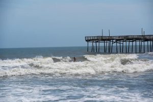
Increased swell along the Outer Banks was reported throughout the day on Saturday, (which brought out surfers in droves but kept swimmers out of the rough waters), and more substantial impacts from Isaias, including high winds and potential coastal flooding, will likely affect the N.C. coastline starting on Monday, per a Saturday evening update from the National Weather Service (NWS) Newport / Morehead City Office.
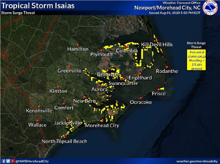
Soundside storm surge and / or oceanfront erosion is a possibility for both Hatteras and Ocracoke islands, but it is still too early to determine specific impacts. If storm surge and coastal flooding becomes an issue, it will likely occur from Monday evening through Tuesday morning.
Rough surf and rip currents were reported throughout Saturday, and the rip current risk will likely remain high through early next week. There is also the potential for dangerous marine conditions, which will linger through Tuesday.
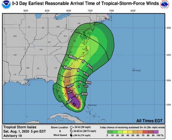
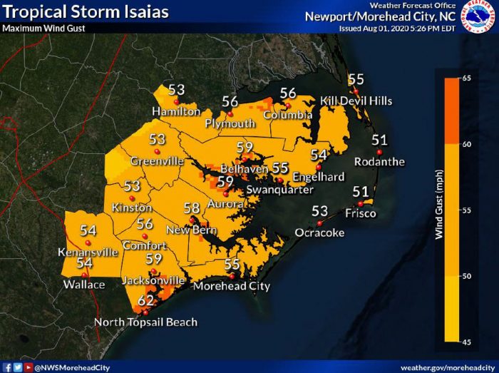
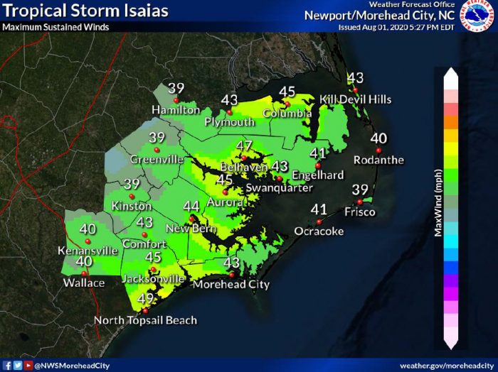
The threat for high winds continues to increase, and there is the potential for tropical-storm-force-winds occurring from Monday evening through Tuesday morning. Downed trees and power outages are possible throughout eastern North Carolina.
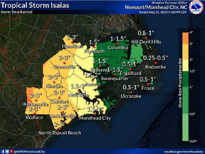
Up to 1” of rain is currently forecast for the Outer Banks, and there is a chance of localized flooding in low-lying areas due to rainfall, but the fast movement of the storm should limit the overall threat.
A mandatory evacuation is in effect for visitors on Hatteras Island as of noon on Saturday, and a mandatory evacuation for residents and property owners will begin on Sunday at 6:00 a.m.
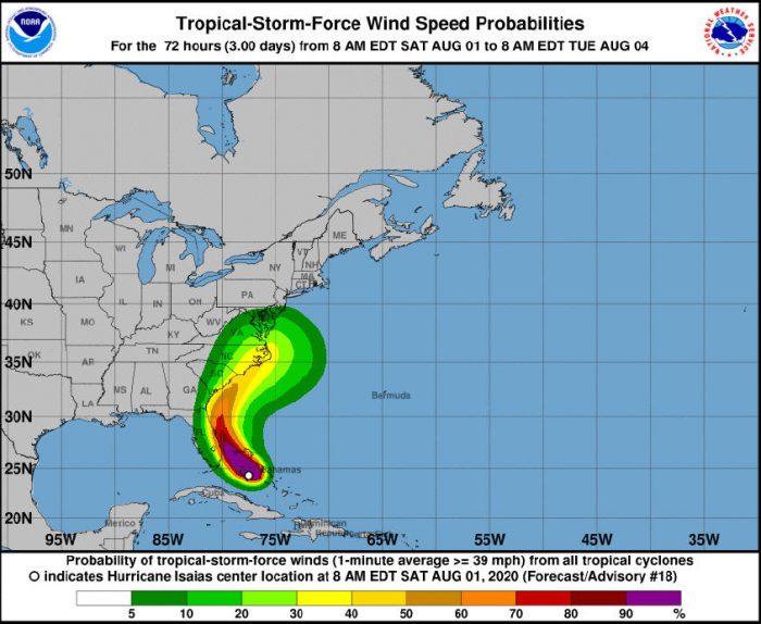
As of 5:00 p.m. on Saturday, Isaias was located about 115 miles southeast of Fort Lauderdale, Florida, with maximum sustained winds of 70 mph, and the storm was moving northwest at 10 mph.
A general northwestward motion with some decrease in forward speed is expected for the next day or so, followed by a north-northwestward motion by late Sunday, and a turn toward the north and north- northeast on Monday and Tuesday, with an increase in forward speed.
On the forecast track, the center of Isaias will approach the southeast coast of Florida tonight and move near or along the east coast of Florida on Sunday and Sunday night. On Monday and Tuesday, the center of Isaias will move quickly from offshore of the coast of Georgia into the southern mid-Atlantic states.
Maximum sustained winds decreased to near 70 mph on Saturday with higher gusts, but some re-strengthening is likely, and Isaias is expected to regain hurricane strength tonight. Slow weakening is expected to occur Sunday night, and will continue through Monday.
Tropical-storm-force winds currently extend outward up to 105 miles from the center of the storm.
The Island Free Press will continue to post updates as soon as they become available. For more information on the local forecast, visit www.weather.gov/mhx for weather information, or the National Weather Service office in Newport / Morehead City’s Facebook page at https://www.facebook.com/NWSMoreheadCity/.


What do you mean. confident we will see impacts? There is a Hurricane coming..