Monday, May 5, 2025

Distant Tropical Storm Eta could bring 3-6″ of rain through Friday

Share post:

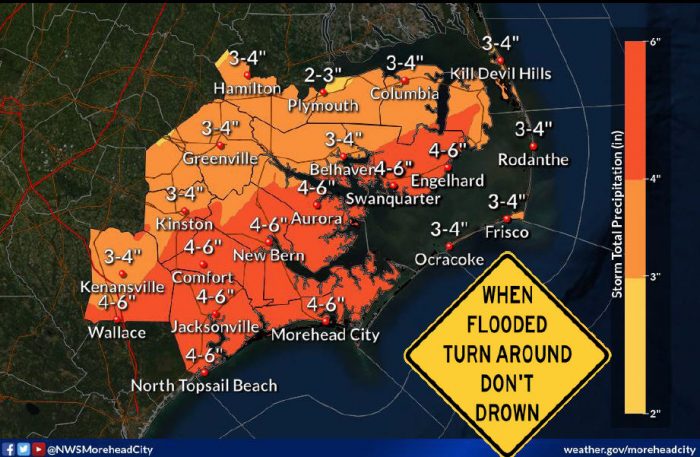
Deep tropical moisture from distant Tropical Storm Eta is forecast to interact with a slow-moving cold front late tonight and tomorrow, resulting in widespread showers and a few thunderstorms, per a Wednesday morning update from the National Weather Service Newport / Morehead City Office.

Heavy downpours are possible and could lead to localized flash flooding. The most likely period for flooding is Thursday, but heavier rainfall will begin late tonight. A widespread 2 to 4 inches of rain is forecast, but as much as 4 to 6 inches is possible closer to the coast.

A Flash Flood Watch is in effect for all Eastern N.C. counties except the Outer Banks.

For more information on the local forecast, visit www.weather.gov/mhx for weather information, or the National Weather Service office in Newport / Morehead City’s Facebook page at https://www.facebook.com/NWSMoreheadCity/.

Trending

Subscribe

Help Support Local News! Subscribe for Free, Upgrade to Premium, or Make a Contribution.

Related articles

New Slash Creek Bridge in Hatteras Village scheduled to open by Memorial Day Weekend

Despite wintertime delays due to cold and snowy weather, the new Slash Creek Bridge in Hatteras Village is...

Hurricane Preparedness Week: Know your risk – water and wind

Courtesy National Weather Service Newport/Morehead City National Hurricane Preparedness Week is May 4-10, 2025, and the National Weather Service and...

Commissioners in eight coastal counties considering resolutions opposing ferry tolls in state budget

From SamWalkerOBXNews.com Commissioners in eight coastal North Carolina counties plan to adopt a joint resolution on Monday that will...

Vehicle wreck causes Friday night power outage on Hatteras and Ocracoke Islands

A one-vehicle collision in northern Rodanthe was the cause of a power outage that affected Hatteras and Ocracoke...