Potential Tropical Cyclone #9 will likely become Tropical Storm Isaias tonight; Elevated surf and rip currents expected this weekend
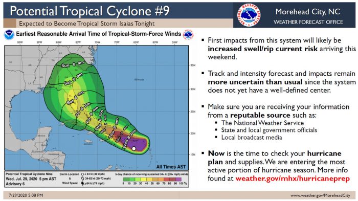
Potential Tropical Cyclone #9 is expected to strengthen into Tropical Storm Isaias tonight, per a Wednesday evening update from the National Weather Service (NWS) Newport / Morehead City Office.
Some weakening is possible due to land interaction tomorrow, with the potential for re-strengthening after landfall being monitored closely by the NWS and the National Hurricane Center.
There is increased confidence that the system will bring elevated surf and rip current activity to Eastern N.C. beaches, including the Outer Banks, beginning this weekend. However, other impacts remain uncertain, and will be dependent on how the storm develops over the next couple of days.
Per the NWS, the track and intensity forecast for this storm is more uncertain than usual, since the system does not currently have a well-defined center.
Regardless, the NWS advises that now is a good time for Outer Banks residents to check their hurricane plans, and guidance can be found at weather.gov/mhx/hurricaneprep.
In a 5:00 p.m. update from the National Hurricane Center, Tropical Cyclone #9 was located about 105 miles south-southwest of St, Croix, with maximum sustained winds of 45 mph, and the system was moving west-northwest at 23 mph.
The Island Free Press will continue to post updates as soon as they become available. For more information on the local forecast, visit www.weather.gov/mhx for weather information, or the National Weather Service office in Newport / Morehead City’s Facebook page at https://www.facebook.com/NWSMoreheadCity/.






Finally some good news
sick!
Yes, Sunday should be sick! Sea you out there
You are right Buddy…we should see some great surf and if we are lucky this weeks tourists will be flushed out early and next weeks tourists stalled for a day or two.