Tropical Storm Debby could bring heavy rains, flooding, and dangerous rip currents this week
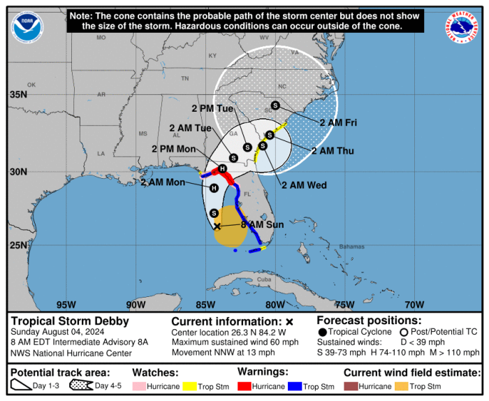
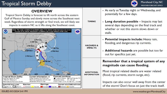
Tropical Storm Debby is expected to make landfall on Monday morning around the Big Bend area of Florida and then move slowly across the Southeast U.S. this week, per an update from the National Weather Service (NWS) Newport/Morehead City office.
There remains considerable uncertainty in the track and impacts beyond Monday due to weak steering currents in the upper atmosphere, but the Outer Banks could see effects from the storm starting on Tuesday or Wednesday, August 6-7
Potential impacts include heavy rains, flash flooding, and dangerous rip currents. Flooding may become a threat late next week or the following week after several days of rainfall. Impacts may last many days depending on the final track, and whether or not the storm slows down or stalls.
As of Sunday at 8:00 a.m., Debby was located about 155 miles southwest of Tampa, Florida, with maximum sustained winds of 60 mph. After Debby makes landfall in Florida, the system is expected to slow down and turn northeastward across northern Florida and southeastern Georgia on Monday and Tuesday.
“While the current forecast track may look promising for our area, there is still significant forecast uncertainty after Debby crosses Florida and Georgia and tracks toward the Atlantic,” stated Dare County Emergency Management Director Drew Pearson in a Saturday evening update. “Even if the storm doesn’t come directly to us, rainfall and increased rip current risk should still be expected next week.”
A list of local Outer Banks resources for information is below.
- For alerts and notifications from Dare County on a customizable list of events or emergencies, (including hurricane evacuations and updates), visit https://www.darenc.gov/departments/emergency-management/emergency-alerts.
- For rip current information and other beach hazards, sign up for text alerts from Dare County, ocean rescue agencies, and the National Weather Service by texting “OBXBeachConditions” to 77295.
- For real-time flood maps that show water level rises throughout Hatteras and Ocracoke Islands, (as well as optional alerts), visit the NC Flood Inundation Mapping and Alert Network.
- For information on the local forecast, visit weather.gov/mhx for general weather information, or the National Weather Service office in Newport/Morehead City’s Facebook page at https://www.facebook.com/NWSMoreheadCity/.
- For up-to-date information on tropical conditions, follow the NWS at gov/mhx/tropical or visit the National Hurricane Center’s website. Just pay attention to all info, and not just the cone graphics.
- To sign up for the Special Needs Registry for hurricane assistance through Dare County, visit https://www.darenc.gov/departments/health-human-services/special-medical-needs-registry or call 252-475-5599.
- For Dare County hurricane information, including reentry procedures, visit https://www.darenc.gov/departments/emergency-management/hurricanes.
- For updates regarding road conditions, visit DriveNC.gov and follow the North Carolina Department of Transportation and NCDOT NC 12 on Facebook. The Dare County Sheriff’s Office also shares local road condition updates on its Facebook page.
- To get notified of ferry delays or cancellations, sign up for text and/or email alerts via the N.C. Ferry System’s FINS system: www.ncdot.gov/fins.
- For up-to-the-minute local information on hurricanes, as they happen, listen to Radio Hatteras at 101.5 (Avon through Hatteras) and 99.9 (Tri-villages), or visit them online at https://www.radiohatteras.org/.
- For online news coverage on active storms, continue to check the Island Free Press.
