

At the April 1 meeting of the Dare County Planning Board, the board approved a zoning text amendment that removed a paragraph referring to a Zone of Influence near Buxton Woods.
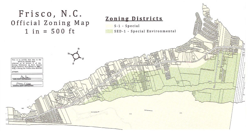
Included in the SED-1 (Special Environmental District) zoning restrictions, but applying to zones that are outside the SED-1 zone, the text to be removed reads as follows:
“Dwelling density within the zone of influence of the SED Ordinance: No multi-family development, townhouses, or condominium project located with ½ mile of any SED-1 zoning district shall exceed a dwelling density of three single family units (whether contained under one or more roofs) per acre or usable land area. Usable land shall be that land defined as “suitable” for septic tank/nitrification field wastewater disposal by the U.S. Department of Agriculture/Soil Conservation Service Soil Survey for Dare County and the Dare County Board of Health.”
Since word spread of the zoning change that is linked to Buxton and Frisco villages, questions have flourished regarding the nearly 40-year-old Zone of Influence reference, and what removing the ordinance means.
A Buxton Civic Association (BCA) meeting is scheduled for Wednesday, April 16, at 7:00 p.m. to dig into these questions further, but background information on the Zone of Influence and how it came to fruition is outlined below.
What is the Zone of Influence?
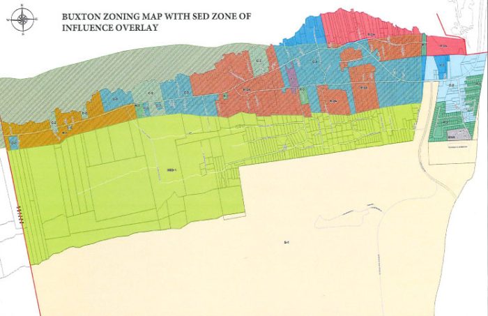
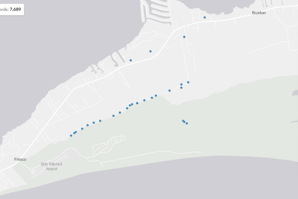
The Zone of Influence applies to a roughly seven-mile-long and half-mile-wide section of Buxton and Frisco that is outside of the the Buxton Woods Reserve-bordering SED-1 zone.
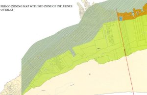
According to the Zone of Influence amendment, in addition to any existing restrictions that correspond with an individual zone, (like R-1, S-1, C-2, C-3, etc.), lots in this area may not be used for a multi-family development, townhouses, or a condominium project, if the project exceeds three single-family units per acre.
It should be noted that depending on the individual zone, other commercial uses outside of multi-family developments are allowed.
For example, properties in C-2 zones can be used for motels, hotels, restaurants, retail stores, RV and mobile home parks, and even theaters, provided that dimensional requirements and other guidelines are met. But multi-family developments are singled out and are not allowed, per the Zone of Influence ordinance.
How did the Zone of Influence come to fruition?
The Zone of Influence paragraph was added to stop a specific 40-unit condo development from being built in 1988, and was an afterthought amendment that followed a massive effort to protect Buxton Woods.
In the late 1980s, the county, state, and local community joined forces to protect sensitive areas of Hatteras Island from development, and namely Buxton Woods, the largest remaining contiguous tract of maritime forest on the Atlantic coast.
At the time, a large swath of Buxton Woods was being eyed by developers as a site for a new golf course, and residents and stakeholders were concerned about the accelerating interest in development by multiple, off-island parties.
Derb Carter, Senior Advisor and Attorney for the Southern Environmental Law Center, was involved in the late-1980s push to protect Buxton Woods.
“I was working with Friends of Hatteras Island at the time, and there were two processes going on,” he said. “There was a process by the state’s Coastal Resources Commission to designate Buxton Woods as an area of environmental concern with state protections, and another effort on the county level to use zoning to protect the forest.”
The N.C. Coastal Resources Commission (CRC), which sets development policy in the state’s 20 coastal counties, voted in 1988 to give Buxton Woods such a designation, and Dare County also adopted special environmental-district ordinances restricting development in order to protect the one-of-a-kind forest, as well as the aquifer that provides water to Avon, Buxton, Frisco, and Hatteras.
“This was all prompted by big development in the forest,” said Carter. “The proposed golf course within Buxton Woods actually prompted all of this. It was led by local citizens who saw the importance of protecting the maritime forest, and who were responding to this development proposal.”
“This all set the stage for the state’s acquisition efforts to establish and build the Buxton Woods Coastal Reserve,” he added.
After these protective measures were implemented, and Buxton Woods was safe from development, a new issue surfaced in the summer of 1988, which is documented in the August 1988 Board of Commissioners meeting minutes.
At this time, a 40-unit condominium project was being planned, which would be located on the soundside of N.C. Highway 12, and outside of the recently created SED-1 zone that protected the core of Buxton Woods.

Nearly a dozen local residents spoke out against the project at the August 1988 meeting, noting that zoning language needed to be added to prevent the planned 40-unit development from moving forward.
“RUSSELL HOLT, Frisco, told the Board that Buxton Woods was being threatened by unrestricted condo development planned for the soundside of Highway 12 in Frisco in an area not protected by the SED,” reads the minutes, summarizing one of the 11 public comments at the meeting.
“Mr. Holt said he had information that a development was planned for Reble Ridge involving 40-condo units. That is in an area which has already been plated and approved for a 6-home subdivision, and yet the developer can come in and build a 40-unit condominium because all he has to do is meet Health Department regulations. Mr. Holt said if that land is clear cut, which it would have to be, there will be virtually nothing left to prevent wind and salt air to rip into the core of Buxton Woods. The sound side of Buxton Woods is the first line of defense, he said. After all the effort to check wild growth, we leave the worst offender of all – the condo developer – with no rules whatsoever except setback rules, height restrictions and sixty percent land use. The very thing that all this is trying to protect, intrusion into Buxton Woods, is going to be under attack if this area isn’t considered in some way to restrict growth on condo development.”
As a result of these concerns, the Board of Commissioners voted to add the Zone of Influence text to prevent the developer from moving forward with the condo plan in September 1988.
“This was in response to concern about that particular condo proposal at that time. That seems to be the main motivating factor to put that Zone of Influence in place,” said Carter. “And a lot has happened since then. When this was all put in place, there was no zoning in that [soundside] area, so a lot has happened in terms of different types of developments being allowed there.”
Carter adds that while the original purpose of the Zone of Influence verbiage dissipated nearly 40 years ago, the restriction still carries some protective weight.
“It still retains importance in limiting the type of development – not to the same extent as the large lot residential requirements in the SED proper – but in a way that can provide some protection to the integrity of the forest and how that area might be developed… Even the name of this amendment, this ‘Influence Area,’ is recognition of the value of protecting the core of the forest.”
“There appears to be a lack of awareness of why this was put in place,” he added. “There were very specific reasons behind it at the time, but I encourage everyone to take some time and look into what is being proposed now, and if it is in the best interest of the local community.”
What prompted the request to remove the Zone of Influence verbiage, and why was it approved?
The Zone of Influence text removal wasn’t initiated to pave the way for new development. Instead, it was proposed to allow a property owner to turn an existing commercial office space into a long-term apartment.
Brian Suth owns a property that is used as offices for several businesses on the edge of N.C. Highway 12 in Frisco. He has been coming to Hatteras Island for more than 15 years, and purchased the commercial property – which is zoned S-1- in early 2025.
After Suth acquired the property, he wanted to turn some of the building’s existing office space into an apartment for a long-term tenant.
“It’s not a ground-up project or anything like that. We were just looking at the lack of long-term housing down here, and wanted to help by converting some existing commercial space,” he said. “It’s the exact same space, and same footprint. There’s clearly a lack of housing – there’s a need for it – so if we can put in an extra apartment, that’s a good thing. But then we ran into this nuanced [issue].”
An S-1 zone allows “all uses,” and according to the county’s S-1 zoning guidelines, the “S-1 special district is established as a transitional area to allow broad flexibility of services and uses while establishing certain density limitations, setbacks, parking requirements and other general requirements.”
Interestingly enough, workforce housing units and educational housing projects are among the first uses listed in the S-1 zoning description, along with “hotels, motels, and similar structures.”
But the Zone of Influence verbiage in the separate SED-1 zoning guidelines contradictorily prevents the development of long-term housing units.
“The owner called me to come meet with him because he wanted to look at adding another dwelling unit at the structure,” said Dare County Planning Director Noah Gillam. “The building already has three apartments, and he wants to add one more from unused space in the building, but you can’t have more than three units per acre.”
Suth didn’t know about the Zone of Influence because while it applies to all zones within a half mile, it’s only mentioned in the SED-1 zoning restrictions.
The “Zone of Influence” is not referenced in any other zoning regulations in the county, so if you bought a property in an S-1, C-2, C-3, or any other zone, and you examined the restrictions for your specific property, you’d never know this caveat existed unless you also researched the SED-1 zone guidelines, (and there would be no logical reason to do so.)
“It just makes sense to remove it,” said Gillam. “It’s not offering protection on an equitable scale, because it allows more invasive purposes. What does the language actually accomplish?”
As an example, Gillam notes that an owner in an S-1 zone could add a motel, hotel, and “multifamily structures and commercial structures.”
But the SED-1’s Zone of Influence directly contradicts the S-1 verbiage when it comes to condos, townhouses, and multi-family units. Hotels, motels, and other commercial developments are still allowed, however, which would inherently be larger developments, with more impact on the land and water supply.
“It’s singling out multi-families, so it looks like it was adopted to block a certain development, because why did it not apply to other more high-intensity and high-density uses?” said Gillam. “Say there’s a property in Buxton that’s zoned S-3, and you want to have an apartment complex with six units per acre. When you look at the S-3 zoning district, you can have that, but the language in another zone says that you can’t. Meanwhile, the person next door can put in a hotel with 50 units. He can do that, but you can’t have six units for per acre for long-term housing.”
“It’s not fair, it doesn’t compare to what has been allowed for the last 30 years, and it just doesn’t make sense,” said Gillam. “It’s a strange structuring of language when it singles out these developments and doesn’t apply to higher density uses. There are properties in the area that are zoned industrial, and the uses can be anything from a concrete plant to diesel fuel production, but you can only put a three-unit apartment on that property.”
Gillam conducted research on the Zone of Influence and these contradictions, (which included research on potential impacts to the local water supply), and detailed his findings and related documentation at the Dare County Planning Board’s April 1 meeting. Based on this data, Gillam stated that he believed removing the Zone of Influence paragraph was reasonable and would not adversely impact the Cape Hatteras well fields or Buxton Woods.
Basically, according to Gillam, removing the paragraph was the best way to allow requests like Suth’s to move forward.
“Nobody loves this village, and area, and character more than I do. And I’m definitely not looking to change that character by any means,” said Suth. “You can add all this short-term stuff, and add more hotels and motels, but addressing long-term housing down there is something you can’t do, and that just doesn’t seem to make sense.”
Is the Zone of Influence related to the Hatteras Island water supply?
Removing the Zone of Influence should have no impact on the water supply, according to the Dare County Water Department.
There are 19 shallow wells and six deep wells located next to Buxton Woods that are used by the county to provide water to Avon, Buxton, Frisco and Hatteras. Not all of these wells are in use at one time, and in 2023, only six of the freshwater wells were accessed during the year.

From these wells, water is transported to the Cape Hatteras Water Treatment Plan, where it is treated through reverse osmosis and anion exchange, and then distributed to storage and to customers via the water main lines.
The SED-1 zone where these wells are located is not affected by the Zone of Influence, since it has its own restrictive guidelines, and the Zone of Influence is specifically designed for areas outside of the SED-1 area. Multiple rules and regulations are in place from state and county agencies to protect the water supply from any unintended influences, like stormwater runoff or pollution from adjacent developments.
“All groundwater supply wells have state-required setbacks that create a separation between a water supply well and potential sources of groundwater contamination,” said Dare County Water Department Customer Service Superintendent Jessica King. “In addition, Dare County requires a setback of 500 feet, which is much greater than the state-required setbacks.”
There are three state agencies that provide protection in terms of regulations when it comes to the water supply – the Coastal Resources Commission, the N.C. Department of Health and Human Services, and the N.C. Department of Environmental Quality. This is in addition to the county’s SED-1 zoning district where the wells are located, which also offers another layer of security.
“Removing the Zone of Influence should have no potential impact to the quality of water,” said King. “It has been previously determined that the wells are outside of the setback range. If, during the planning and development phase, it is determined that construction will be within the setback range, then a block would be created to prevent development within that area.”
The Cape Hatteras Reverse Osmosis and Anion Exchange Water Plant is designed to serve 5,500 year-round customers, although that number certainly skyrockets in the summer months.
“Next year, the Cape Hatteras Water Plant will be discontinuing use of the anion exchange process and replacing it with an additional reverse osmosis train,” said King. “As a result, we will discontinue use of the shallow wells and will only use the deep wells. This switch will also increase the number of customers that the plant can serve, since the new train will have a greater treatment capacity than the anion exchange filters.”
Considering that RV parks, hotels, and motels can be developed in Buxton and Frisco, it seems that allowing long-term housing options with fewer units than a motel or mobile home park would inherently put less pressure on the water supply and other community utilities.
Still, there are lingering questions by some stakeholders about whether adding more multi-family developments outside the Buxton Woods area – even if other types of developments are allowed – will have a trickle-down effect on the groundwater.
“The Zone of Influence itself is a half mile wide and nearly eight miles long, so we’re talking about a very big area,” said Alyson Flynn, Coastal Advocate & Environmental Economist for the North Carolina Coastal Federation. “We need to have discussions of how lifting this will impact and change the scope and feel of our community in Buxton and Frisco, and most importantly, if there will be any impact on our water supply.”
Fylnn has been studying the Zone of Influence and the county’s water supply and zoning regulations since the April 1 Planning Board meeting, and she is hoping that more questions will be asked and answered before the Zone of Influence text is officially removed at a future Dare County Board of Commissioners meeting.
“Removing this text could really open up the doors for condominiums, cluster homes, and multi-housing family units, and this will all have an impact on our water quality through stormwater runoff, or eliminating the vegetation buffer,” said Flynn. “One of our recommendations is that we fully understand how this impacts drinking water. Because this ordinance has been in place for so long, it would be helpful to have a workgroup to assess these impacts so we can make a more informed decision, rather than just removing it and finding out the hard way down the road.”
What’s next for the Zone of Influence
Now that the Zone of Influence text removal has cleared the Dare County Planning Board, a public hearing will be held in conjunction with a Dare County Board of Commissioners meeting – likely at the next meeting on May 3 – where the change will be approved or unapproved by the seven-member board.
A meeting is also being held by the Buxton Civic Association on Wednesday, April 16, at 7:00 p.m. at the old Buxton Volunteer Fire Department next to Burrus Field to explore the issue further.
“This meeting is intended to share the facts,” stated the BCA in a social media update. “Commissioner Ballance, Alyson Flynn with the N.C. Coastal Federation, and representatives from Dare County Planning and Zoning have all been invited to speak… we strongly encourage residents to attend, hear directly from officials, ask questions, and make their own informed decisions.”
