Soundside flooding subsides, but ocean overwash has begun …WITH SLIDE SHOW
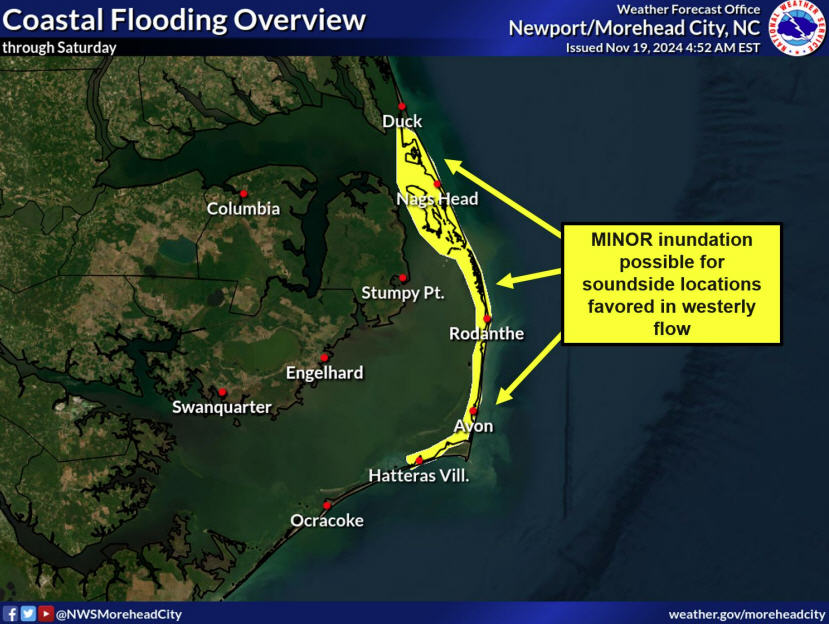
All of Hatteras Island saw moderate soundside flooding on Wednesday from the high winds generated by a coastal storm.
The low pressure area moved in from the west on Tuesday night with some rain and then headed offshore along the Virginia-North Carolina border on Wednesday afternoon.
Gale force west winds turned more to the northwest later in the day on Wednesday, and before they subsided last night, all of Hatteras was dealing with the storm tide.
The first areas affected were Pea Island and the tri-villages. But afternoon, Avon was getting the tide, and by late afternoon, the water had started rising quickly in Buxton, Frisco, and Hatteras.
Interestingly, Ocracoke got almost no flooding. Just a few degrees difference in wind direction at various places on the island makes all the difference in how much tide we get.
In Brigands’ Bay in Frisco, there was a good deal of tide, though nothing near the surges we saw after hurricanes Irene and Sandy.
According to the National Weather Service in Newport, N.C., winds gusted to 60 mph in Hatteras village, 54 mph in Frisco, and 59 mph at Oregon Inlet.
The water quickly went down overnight, and this morning was sunny and bright.
However, the ocean was churned up, and it began coming onto Highway 12 this afternoon.
By 4 p.m., which was just about high tide, there was ocean tide on the road south of the temporary bridge at Pea Island Inlet, the S-curves and Mirlo Beach in northern Rodanthe, and at the motels in north Buxton.
Island Free Press photographer Don Bowers reported about 3:30 p.m. that the sand was washed away at about 100 yards of the new dune at the S-curves. He said water was washing over the sandbags, into the road, across to the sound, and pooling around the Cape Hatteras Electric Cooperative power poles in the areas.
Bowers said that vehicles were making it through the tide, though drivers were timing their passage – picking a time in between the big waves and making a run for it.
As of 5:30 p.m., Highway 12 was still open, though covered with water and sand in places.
Meteorologists at the National Weather Service Office in Newport, N.C., are forecasting the heavy seas will continue until at least Sunday.
The low pressure that brought us the problems yesterday is slowly moving northeast, but the Outer Banks will be sandwiched between that low and a high pressure over the Lower Great Lakes into the weekend.
Waves at the buoy about 13 miles east of Oregon Inlet were 17 feet this morning. The Weather Service says seas will remain at 10-plus feet through Saturday night.
The coastal flood advisory was cancelled this afternoon, but the high surf advisory remains in effect until 8 a.m. Sunday.
Ocean overwash can be expected on Highway 12 north of Cape Hatteras at high tide until at least Sunday. High tides will be in the late afternoon and early evening and early morning hours through the weekend.
Motorists can expect intermittent delays as the Department of Transportation crews work to clear sand and water off the road.
Hatteras Island road conditions are available on Island Free Press by clicking on the yellow tab at the top of the Front Page on the right.
You can also check the DOT’s Highway 12 Facebook page at http://www.facebook.com/NCDOT?fref=ts.
CLICK HERE TO VIEW SLIDE SHOW


