Public scoping period opens for proposed infrastructure improvements

Public scoping period opens for proposed infrastructure improvements
The National Park Service is seeking public comment on proposed infrastructure improvement projects identified in the final Off-Road Vehicle (ORV) Management Plan that would facilitate visitor access to key recreational areas while providing resource protection to wildlife and plants within Cape Hatteras National Seashore.
The Park Service is preparing an Environmental Assessment for the proposed construction of parking lots, pedestrian access points and accessible boardwalks, and unpaved interdunal roads and beach access ramps for ORVs at various locations in the seashore.
Scoping is done in the initial phase of a project to seek input from a variety of sources, according to the Park Service. The input is used to identify issues, areas requiring additional study, and topics that will be analyzed in the EA process.
“This is an opportunity for you to provide us with your suggestions, comments, and concerns regarding beach access at Cape Hatteras,” the Park Service says.
The 30-day public scoping period opens today and closes on March 31. The public scoping period is part of the process to prepare an Environmental Assessment pursuant to the National Environmental Policy Act of 1969.
The Final Off-Road Vehicle Management Plan identified potential projects that would facilitate visitor access to key recreational areas within the seashore while providing resource protection.
These projects relate to the development of parking areas, unpaved roads and beach access ramps, pedestrian access points, and accessible boardwalks and include the following:
A 10-car parking area at the former site of the U.S. Coast Guard Station on Bodie Island
A 10-car parking area at the former site of the U.S. Coast Guard Station on Bodie Island
A 10-car parking area at the former site of the U.S. Coast Guard Station on Bodie Island
A 10-car parking area at the former site of the U.S. Coast Guard Station on Bodie Island
A handicap accessible boardwalk at Coquina Beach on Bodie Island
A handicap accessible boardwalk at Coquina Beach on Bodie Island
A handicap accessible boardwalk at Coquina Beach on Bodie Island
A handicap accessible boardwalk at Coquina Beach on Bodie Island
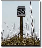
A handicap accessible boardwalk at the Ramp 55 parking area on Hatteras Island
A handicap accessible boardwalk at the Ramp 55 parking area on Hatteras Island
A handicap accessible boardwalk at the Ramp 55 parking area on Hatteras Island
A handicap accessible boardwalk at the Ramp 55 parking area on Hatteras Island
A handicap accessible boardwalk at the Ocracoke Pony Pens
A handicap accessible boardwalk at the Ocracoke Pony Pens
A handicap accessible boardwalk at the Ocracoke Pony Pens
A handicap accessible boardwalk at the Ocracoke Pony Pens
A handicap accessible boardwalk at the Ocracoke Day Use Area
A handicap accessible boardwalk at the Ocracoke Day Use Area
A handicap accessible boardwalk at the Ocracoke Day Use Area
A handicap accessible boardwalk at the Ocracoke Day Use Area
Additional access road from NC 12 to fee station at Coquina Beach
Additional access road from NC 12 to fee station at Coquina Beach
Additional access road from NC 12 to fee station at Coquina Beach
Additional access road from NC 12 to fee station at Coquina Beach
An off-road vehicle (ORV) ramp and 10-car parking area 0.5 miles south of Coquina Beach
An off-road vehicle (ORV) ramp and 10-car parking area 0.5 miles south of Coquina Beach
An off-road vehicle (ORV) ramp and 10-car parking area 0.5 miles south of Coquina Beach
An off-road vehicle (ORV) ramp and 10-car parking area 0.5 miles south of Coquina Beach
A 10-car parking area at Ramp 4 for foot trail to Bodie Island spit with footbridge across wetland
A 10-car parking area at Ramp 4 for foot trail to Bodie Island spit with footbridge across wetland
A 10-car parking area at Ramp 4 for foot trail to Bodie Island spit with footbridge across wetland
A 10-car parking area at Ramp 4 for foot trail to Bodie Island spit with footbridge across wetland
A 20-car parking area and handicap accessible boardwalk at Ramp 23
A 20-car parking area and handicap accessible boardwalk at Ramp 23
A 20-car parking area and handicap accessible boardwalk at Ramp 23
A 20-car parking area and handicap accessible boardwalk at Ramp 23
A 10-car parking area about 1.0 mile south of Ramp 23 with foot trail to the beach
A 10-car parking area about 1.0 mile south of Ramp 23 with foot trail to the beach
A 10-car parking area about 1.0 mile south of Ramp 23 with foot trail to the beach
A 10-car parking area about 1.0 mile south of Ramp 23 with foot trail to the beach
An ORV Ramp 25.5 with foot trail or boardwalk to the beach
An ORV Ramp 25.5 with foot trail or boardwalk to the beach
An ORV Ramp 25.5 with foot trail or boardwalk to the beach
An ORV Ramp 25.5 with foot trail or boardwalk to the beach
A 5-car parking area at soundside Ramp 48
A 5-car parking area at soundside Ramp 48
A 5-car parking area at soundside Ramp 48
A 5-car parking area at soundside Ramp 48
An ORV Ramp 32.5 (Little Kinnakeet) with a 10-car parking lot and foot trail to the beach
An ORV Ramp 32.5 (Little Kinnakeet) with a 10-car parking lot and foot trail to the beach
An ORV Ramp 32.5 (Little Kinnakeet) with a 10-car parking lot and foot trail to the beach
An ORV Ramp 32.5 (Little Kinnakeet) with a 10-car parking lot and foot trail to the beach
A 10-car parking area at soundside access #59 with foot trail from highway to the beach
A 10-car parking area at soundside access #59 with foot trail from highway to the beach
A 10-car parking area at soundside access #59 with foot trail from highway to the beach
A 10-car parking area at soundside access #59 with foot trail from highway to the beach
A handicap accessible boardwalk at Ramp 34
A handicap accessible boardwalk at Ramp 34
A handicap accessible boardwalk at Ramp 34
A handicap accessible boardwalk at Ramp 34
A handicap accessible boardwalk to sound at Haulover Beach Parking Area
A handicap accessible boardwalk to sound at Haulover Beach Parking Area
A handicap accessible boardwalk to sound at Haulover Beach Parking Area
A handicap accessible boardwalk to sound at Haulover Beach Parking Area
A 15-car parking area west side of highway at/near Kite Point
A 15-car parking area west side of highway at/near Kite Point
A 15-car parking area west side of highway at/near Kite Point
A 15-car parking area west side of highway at/near Kite Point
A 5-car parking area west side of highway at/near soundside access 60
A 5-car parking area west side of highway at/near soundside access 60
A 5-car parking area west side of highway at/near soundside access 60
A 5-car parking area west side of highway at/near soundside access 60
A 50-car parking area at the former Buxton Coast Guard Station w/ handicap accessible boardwalk
A 50-car parking area at the former Buxton Coast Guard Station w/ handicap accessible boardwalk
A 50-car parking area at the former Buxton Coast Guard Station w/ handicap accessible boardwalk
A 50-car parking area at the former Buxton Coast Guard Station w/ handicap accessible boardwalk
A handicap accessible boardwalk at Lighthouse Beach
A handicap accessible boardwalk at Lighthouse Beach
A handicap accessible boardwalk at Lighthouse Beach
A handicap accessible boardwalk at Lighthouse Beach
A 5-car parking area at Loran Road w/ new handicap accessible boardwalk to the beach
A 5-car parking area at Loran Road w/ new handicap accessible boardwalk to the beach
A 5-car parking area at Loran Road w/ new handicap accessible boardwalk to the beach
A 5-car parking area at Loran Road w/ new handicap accessible boardwalk to the beach
An elevated section of Lighthouse Road to address flooding at ramps 43 and 44
An elevated section of Lighthouse Road to address flooding at ramps 43 and 44
An elevated section of Lighthouse Road to address flooding at ramps 43 and 44
An elevated section of Lighthouse Road to address flooding at ramps 43 and 44
An unpaved interdunal road (IDR) between Ramp 45 and 49 w/new ORV Ramp 47.5 to the beach
An unpaved interdunal road (IDR) between Ramp 45 and 49 w/new ORV Ramp 47.5 to the beach
An unpaved interdunal road (IDR) between Ramp 45 and 49 w/new ORV Ramp 47.5 to the beach
An unpaved interdunal road (IDR) between Ramp 45 and 49 w/new ORV Ramp 47.5 to the beach
Widen Ramp 49 and add connector road and 5 car parking lot to Billy Mitchell Rd. near Frisco Campground
Widen Ramp 49 and add connector road and 5 car parking lot to Billy Mitchell Rd. near Frisco Campground
Widen Ramp 49 and add connector road and 5 car parking lot to Billy Mitchell Rd. near Frisco Campground
Widen Ramp 49 and add connector road and 5 car parking lot to Billy Mitchell Rd. near Frisco Campground
An unimproved 20-car parking area near the Pole Road/Spur Road intersection
An unimproved 20-car parking area near the Pole Road/Spur Road intersection
An unimproved 20-car parking area near the Pole Road/Spur Road intersection
An unimproved 20-car parking area near the Pole Road/Spur Road intersection
A handicap accessible boardwalk at/near north ferry terminal parking area on Ocracoke
A handicap accessible boardwalk at/near north ferry terminal parking area on Ocracoke
A handicap accessible boardwalk at/near north ferry terminal parking area on Ocracoke
A handicap accessible boardwalk at/near north ferry terminal parking area on Ocracoke
An ORV Ramp 59.5 at north Ocracoke
An ORV Ramp 59.5 at north Ocracoke
An ORV Ramp 59.5 at north Ocracoke
An ORV Ramp 59.5 at north Ocracoke
A 5-car parking area at the west/north side of highway entrance of Barrow Pit Road
A 5-car parking area at the west/north side of highway entrance of Barrow Pit Road
A 5-car parking area at the west/north side of highway entrance of Barrow Pit Road
A 5-car parking area at the west/north side of highway entrance of Barrow Pit Road
An ORV Ramp 63 across from Scrag Cedar Road
An ORV Ramp 63 across from Scrag Cedar Road
An ORV Ramp 63 across from Scrag Cedar Road
An ORV Ramp 63 across from Scrag Cedar Road
The Environmental Assessment (EA) is underway. After the EA is made public, there will be another opportunity to provide public comment before the Park Service announces a decision.
The National Environmental Policy Act (NEPA) requires that an EA include a minimum of two alternatives. Initial internal project scoping identified the following alternatives for consideration in the EA.
No Action: The potential development identified in the ORVMP would not be constructed and visitors would continue to access the beach through existing ramps, roads, and parking areas.
No Action: The potential development identified in the ORVMP would not be constructed and visitors would continue to access the beach through existing ramps, roads, and parking areas.
No Action: The potential development identified in the ORVMP would not be constructed and visitors would continue to access the beach through existing ramps, roads, and parking areas.
No Action: The potential development identified in the ORVMP would not be constructed and visitors would continue to access the beach through existing ramps, roads, and parking areas.
Proposed Action: Some or all of the proposed development identified in the ORVMP would be constructed providing visitors additional access opportunities.
Proposed Action: Some or all of the proposed development identified in the ORVMP would be constructed providing visitors additional access opportunities.
Proposed Action: Some or all of the proposed development identified in the ORVMP would be constructed providing visitors additional access opportunities.
Proposed Action: Some or all of the proposed development identified in the ORVMP would be constructed providing visitors additional access opportunities.
Written comments may be submitted through the NPS Planning, Environment, and Public Comment (PEPC) website at: http://parkplanning.nps.gov/caha. Select the “Proposal to Construct New Development that Facilitates Public Access” link to view the scoping documents. Comments can also be mailed to: Superintendent, Cape Hatteras National Seashore, 1401 National Park Drive, Manteo, NC 27954. To ensure your comments are included in this process, they must be entered into PEPC or postmarked by March 31, 2012.
Comments will not be accepted by fax, e-mail, or in any other way than those specified above. Bulk comments in hard copy or electronic formats submitted on behalf of others will not be accepted.
FOR MORE INFORMATION
Click here for a map that includes all of the proposed oceanside and soundside ramps.
To go straight to the public comment form: http://parkplanning.nps.gov/commentForm.cfm?documentID=46004
Subject
Name
(required, will not be published)
(required, will not be published)
City :
State :
Your Comments:
May be posted on the Letters to the Editor page at the discretion of the editor.
May be posted on the Letters to the Editor page at the discretion of the editor.
May be posted on the Letters to the Editor page at the discretion of the editor.
May be posted on the Letters to the Editor page at the discretion of the editor.


