Geographer explains origins of Outer Banks place names
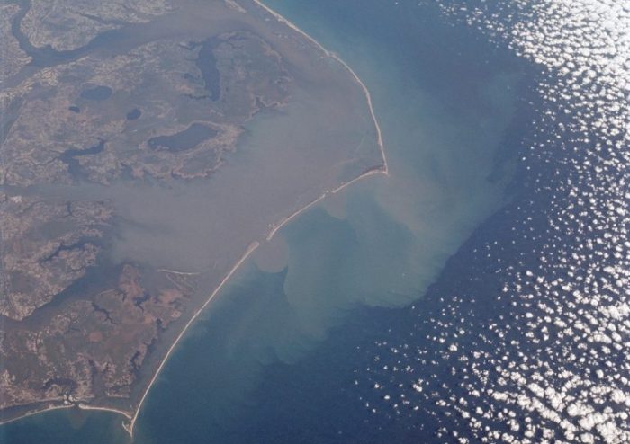
Bodie Island, Jockeys Ridge, Kill Devil Hills, Kitty Hawk, Monkey Island, Nags Head, No Ache Island, Ocracoke Island – these and Outer Banks place names come with rich stories about their origins, but how many are accurate?
Geographer Roger Payne made it his mission long ago to get to the truth.

Payne’s interest in the place names of the Outer Banks was sparked “many, many years ago” with his first trip to North Carolina’s barrier islands, he writes in the preface to his new book, “Outer Banks Gazetteer: The History of Place Names From Carova to Emerald Isle.”
“While waiting for the ferry at Oregon Inlet (before the bridge), I asked my dad, ‘Why is this inlet called Oregon Inlet?’ He hesitated, thought for a while, and responded, ‘That’s a good question.’ It seemed an unlikely name to be on the Outer Banks of North Carolina. After all, what does Oregon have to do with North Carolina? Thus began my interest in geographic names of the Outer Banks and in geographic names in general,” Payne recalls about that 1959 trip.
From that visit on, he kept records of unusual names on the Outer Banks. Even while attending East Carolina University, “I continued my interest in the Outer Banks and its place names,” Payne writes.
The reference guide published in March by the University of North Carolina Press contains more than 4,000 entries on the region’s place names and includes the history of beaches, inlets, towns and communities, islands, rivers and sand dunes, including the large dune Jockeys Ridge in Dare County. While local stories say that the top of the sand dune “afforded an excellent view of a horsetrack,” which Payne said there’s no record of, the true origin of the name is from an early landowner, according to Payne’s research.
Payne also includes locations that no longer exist, such as inlets that have disappeared due to erosion or storms, Native American villages and abandoned towns. For example, though there’s no trace of Gull Island today, the Carteret County island was in Back Sound between Shackleford Banks and Harkers Island and was prominent until the mid-20th century.
The guide is available online and in many Outer Banks stores.
Payne, who is executive secretary emeritus of the U.S. Board on Geographic Names, earned his bachelor’s in geography and history in 1969 and his master’s in geography in 1972, both from the Greenville-based institution.
He began his career with the U.S. Geological Survey in 1974, officially retiring in 2012. The USGS, created by Congress in 1879, is the country’s largest water, earth and biological science and civilian mapping agency and the sole science agency for the Department of the Interior.
Payne also served as webmaster for the nation’s official geographic name repository, Geographic Names Information System, as USGS’ representative lecturer on mapping and general cartography to schools in northern Virginia, and as adjunct professor at several universities including Old Dominion University, East Carolina University, George Mason University and George Washington University.
Payne told Coastal Review in a recent interview that he was always interested in and even drawn to the Outer Banks since his first visit more than 50 years ago. Even then, he was already interested in the geographic names.
“However, it was not until I joined the U.S. Geological Survey as a researcher in the office responsible for geographic names on maps and in the United States that I discovered that my interest and its application was subject to principles, policies, and procedures officially. Of course, I already had degrees in geography and history, but then took numerous post-graduate course in linguistics and later, data base design,” he said.

Payne explained that his primary goal with his “Gazetteer” was to preserve the rapidly disappearing names and their original meaning when applied.
“Even the very old folk I interviewed — I interviewed hundreds — did not remember original meanings,” he said, adding that geographic names serve as markers for navigating one’s environment while simultaneously providing insight into the morphing and evolution of that culture.
“Of particular interest to me was to determine, prove, and document the numerous published name origins that are nothing more than folk etymology, which is prevalent everywhere, not just the Outer Banks,” he said.
“Some of these highly circulated renditions are clearly tongue in cheek, but others are true folk etymology where fabrication is used to complete unknown or forgotten meanings and are really believed by visitors and even local folk, including many now older local folk. Full original meanings for application are researched appropriately, documented, and provided in the book with my analysis,” he said, explaining that the meanings are based on more than 30 years of direct toponymic, or place name, experience and research.
There are also “educated speculations” based upon years of toponymic fieldwork and experience for certain things and names where intensive research and scores of interviews yielded no results or conflicting results, he said.
“Additionally, I have — I am convinced — unraveled the mysteries of the historical inlet situation in the Roanoke Island area as well as the historical inlet situation along the entire Outer Banks, which does appear conflicted in many sources. My rendition is based upon careful, detailed examination of all maps published in the area since 1585.”
This is not Payne’s first publication on Outer Banks place names.
In 1985, he published “Place Names of the Outer Banks.” Payne explained that when he determined that there was interest in the topic, he decided to publish his work.
“There are numerous place names books published, but since there was no such book of the Outer Banks, I decided in my spare time then, between working and family duties, to gather my notes and publish,” he said.
“The 1985 version is woefully deficient and obviously well out of date. Further, in the seven-year period preparing that version one had to actually visit individual facilities and actually examine each source since it was prior to full internet capability and the onslaught of digitizing everything,” he said.
The 1985 edition was adequate at the time, he continued, but with the advent of digitizing historical and other maps, as well as the availability of primary and other documents online, he said he was able to enhance the information culminating in this gazetteer.
“Specifically, the various myths of naming by folk etymology have been dispelled with the researched and documented actual reason and meaning for the names. This version contains over 4,000 entries, four times the number of the 1985 version, and everything is cross-referenced to a bibliographic citation in this volume,” he told Coastal Review about the 2021 edition.
Payne retired from the USGS in 2006, but two weeks later he was rehired by the same office to manage database transitions, monitor two websites as well as to respond to inquiries. “I responded to over 15,000 such inquiries from 2006 to 2012,” he said.
After 2012, he continued as a volunteer, managing and monitoring the United States’ geographic names program for Antarctica. After 2013, he said he was able to focus his studying Outer Banks Place names.
“It was, in my opinion, well worth the effort since there are more than 4,000 entries for the new version over the 1,000 in the 1985 version and the latest version corrects numerous and varied errors and lack of information because of lack of resources,” Payne said. “Unlike 1985, this version contains a ‘selected’ bibliography as well as each name cross-referenced to the source. I have provided true and documented name origins for almost every name along with all known stories, legends, and whatnot, which of course I think makes very interesting reading.”
And Oregon Inlet, by the way, which opened during a hurricane in 1846, is named after the first vessel to pass through it, the side-wheeler Oregon.







I bought the book on Amazon. Seems interesting to me. Thanks for the information.