More rain does little to reduce Outer Banks, northeast N.C. drought

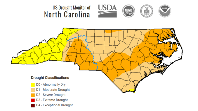
Despite another round of rainfall over the past week, the Outer Banks and northeastern North Carolina remain in the clutches of severe drought.
There were no changes in the update published by the N.C. Drought Monitor on Thursday.
Around 0.5 to 0.75 inches of rain fell in eastern North Carolina from a fast-moving coastal storm Tuesday night and early Wednesday, and around 0.5 inches from a frontal system the previous weekend.
But state climatologists said earlier this month an extended period of wet weather will be needed to overcome the dry conditions that have plagued the region since late summer. North Carolina is just coming off its driest November in nearly a century.
Severe drought is the second category of the four drought classifications based on the U.S. Drought Monitor. Last May, portions of six counties were briefly classified as severe. Prior to that time, severe drought occurred during the month of October 2019.
An open burning ban was instituted statewide in late November, but rain in early December brought some minor relief and allowed the ban to be lifted. Several wildfires scorched several areas in the mountains in late fall, including one that burned over 1,000 acres of Pilot Mountain State Park.
Virtually all of the state is experiencing dry conditions based on factors including streamflow, groundwater levels, reservoir levels, soil moisture, and fire danger.
The N.C. Drought Management Action Council said earlier this month current conditions and forecast models which reflect the warm, dry conditions that a La Nina weather pattern often brings, could lead to drought conditions continuing through the winter months.
In past droughts, areas on the mainland that include several wildlife refuges have been prone to wildfires that have burned the nutrient-rich peat soils for months.


