Dare County launches new Bird’s-Eye Viewer Map

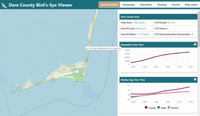
The Dare County Geographical Information System (GIS) Department has announced the launch of a new Bird’s-Eye Viewer Map that allows users to easily visualize the various geographical, economic, and socio-demographics of Dare County—and to learn more about how this information has changed over time.
“We created this map so Dare County citizens and visitors can easily visualize important information about the county and its population in hopes that it will provide them with essential information about our diverse community and serve as a comprehensive tool that will ultimately empower them to make informed decisions,” said Dare County GIS Analyst Kristen Stilson.
The area overview portion of the Bird’s-Eye Viewer Map details the total number of square miles that Dare County comprises in both land and water, as well as the total number of parcels within the county, the number of incorporated towns, and the number of unincorporated communities.
The new map also shows Dare County’s current population, median age, median household income, median home value, median cost of rent, and percentage of the population in the labor force. In addition, the Bird’s-Eye Viewer Map highlights how these statistics have changed each decade since the 1970s and allows users to view the local statistics in relation to both North Carolina and the United States as a whole.
A wealth of additional information about Dare County and its residents is available via the Bird’s-Eye Viewer Map when users click the tabs on the top of the page and zoom in or zoom out while navigating to a specific geographic area to learn more about that area’s geography, population, housing, and household income.*

Geography: The geography tab offers insights into Dare County’s many unique ecosystems, land classifications, and rare species of flora and fauna. Be sure to click the buttons to see the list of species and view the land classification layers.

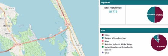
Population: The population tab shows statistics about Dare County’s population, including race, median age, education level, and family type.

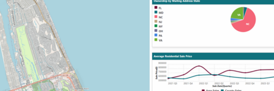
Housing: The housing tab provides detailed information on residential property sales, home values, and ownership by state, as well as household size and the percentage of their income that local residents spend on rent in Dare County.

Income: The income tab shows a specific area’s median household income by age group, as well as residents’ employment status, approximate commute time to their place of employment, and the number of workers who are employed in several key industries that range from real estate, retail, construction and manufacturing to healthcare, public administration, education and accommodations.
*As users navigate around the map of Dare County and zoom in or zoom out to locate certain areas of interest, the data that is displayed on their screen will change to reflect the statistics for the specific portion of the map that the user is currently viewing.
To view the Dare County Bird’s-Eye Viewer Map, click here.
For more information, as well as many additional mapping resources, please visit www.DareNC.gov/GIS.
Note: The data used to create Dare County’s Bird’s-Eye Viewer Map was obtained from the U.S. Census Bureau, 2017-2021 American Community Survey (ACS) 5-year Estimates, North Carolina Natural Heritage Program, National Land Cover Database, North Carolina Department of Revenue, Dare County Tax Department and IPUMS National Historical GIS. U.S. Census data and sales ratio data are updated annually, and residential property sales and home values will be updated weekly. Data regarding natural communities/species and land coverage will be updated as that information becomes available.


