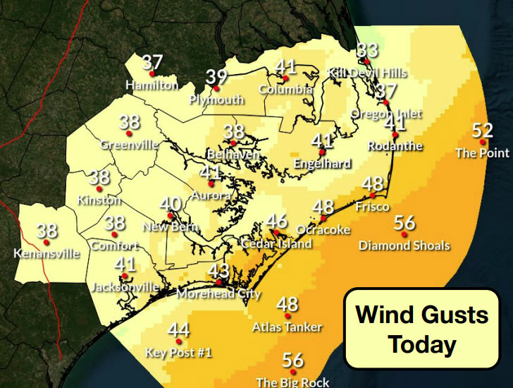
Matthew still forecast to re-curve south and east but confidence is low
The Dare County Control Group met again this morning to review Hurricane Matthew.
“The current forecast from the National Hurricane Center shows the storm tracking further south than previously predicted and away from Dare County,” according to a news release. “While this is an improved forecast for our area, it is too early to know for sure that this latest track will continue to hold its course.”
Dare County officials are urging residents and visitors “to remain vigilant and continue to closely monitor the storm because even moderate changes in the projected path could lead to significant impacts” for the area.
The state of emergency declaration for the county and its six towns will remain in place in case conditions change and protective measures, such as evacuations, become necessary.
The county’s beaches are already experiencing dangerous rip currents and rough surf conditions that are expected to continue. Dare County Emergency Management strongly urges everyone to stay out of the ocean.
Dare County Public Works is operating on a regular trash collection schedule. Because of the winds that are anticipated in the coming days, residents are asked to roll up and secure their garbage cans as quickly as possible after pickup to reduce the risk of injury and property damage.
To receive email updates directly from Dare County Emergency Management, register online at www.darecountyem.com and follow @DareCountyEM on Twitter.
Residents and visitors may contact Dare County Emergency Management by calling 252.475.5655 or visiting www.darenc.com for updated information.
For local weather information, go to http://www.weather.gov/mhx/. The page has links to the tropical forecast. You can find the beach forecast, including the rip current forecast on the Island Free Press home page — at the top right. Click on the icon with the beach umbrella.
Visitor Services: The NPS visitor center and off-road vehicle permit office on Ocracoke Island will stay closed until further notice. NPS visitor services may be suspended on Hatteras Island, Bodie Island, at Fort Raleigh National Historic Site, and at Wright Brothers National Memorial on Thursday. Additional information will be sent out once Outer Banks Group management has made a determination based on current storm forecast. The parks’ social media sites on Facebook and Twitter will also be updated with current information.
Beach Access Ramps: All off-road vehicle beach access ramps on Ocracoke Island will be closed to vehicles by the end of today. Daily beach access ramp status updates are posted on the Cape Hatteras National Seashore Facebook page at http://facebook.com/capehatterasns.
Rip Currents: There is a high risk of dangerous rip currents, a high surf advisory, and rough surf north of Cape Hatteras today. A high risk of rip currents will continue throughout the storm period. For more information on rip currents safety go to http://www.ripcurrents.noaa.gov.
RELATED STORIES
Latest forecast moves Matthew farther away from Outer Banks
Hyde issues state of emergency, orders evacuations
State of Emergency declared in Dare, Matthew still aiming for Outer Banks
Matthew takes aim on southeast coast, Outer Banks
Powerful Matthew’s impacts on Outer Banks still in question
Outer Banks is keeping an eye on Matthew


