Latest Matthew forecast about the same, but focus now on rain
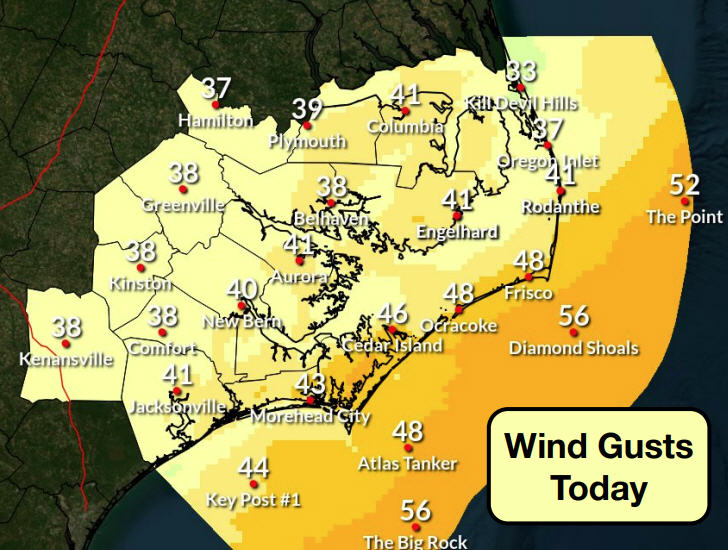
This morning, Richard Bandy, the meteorologist-in-charge of the local National Weather Service Office in Newport/Morehead City, began the first of two daily webinars on Hurricane Matthew with the headlines, which are promising for the Outer Banks.
The National Hurricane Center track, Bandy said, hasn’t changed much since yesterday afternoon. Matthew is forecast to hug the southeast coastline until somewhere in South Carolina when the storm will make a sharp turn to the east, heading out to sea — and then re-curving back south toward the Bahamas and Florida as a tropical storm.
Then he said that forecast models have returned to a consensus of keeping the hurricane well off the North Carolina coast.
And, finally, he repeated what has become something of a mantra this week in discussions about Matthew, “But confidence remains low in the exact forecast track.”
“With all the model inconsistencies and uncertainties,” the Weather Service’s morning bulletin noted — as it has for a couple briefings — “it is still within the margin of error for the storm to pass closer to the coast, which would increase the impacts across coastal areas and inland.”
At 11 a.m., Hurricane Matthew was clearing the Bahamas and heading toward the Florida coast as a Category 4 hurricane with winds of 140 mph. The storm was moving northwest at 14 mph.
Hurricane warnings extend from Florida, through the Georgia coast, and into the southernmost areas of South Carolina with a hurricane watch for much of the remainder of the South Carolina coast.
There are no watches or warnings in North Carolina, but the National Weather Service and emergency managers are urging “continued vigilance.”
That being said, in this morning’s webinar, Bandy focused especially on the expected rainfall from the tropical system.
“The potential for rainfall and flash flooding is taking center stage as one of the primary and most dangerous threats from Matthew,” the Weather Service said this afternoon.
First, the current gusty winds and off-and-on cloudiness and rain showers on Hatteras and Ocracoke have nothing to do with Matthew and are the result of a stalled front — or trough — just off the coast.
The trough, Bandy said, will still be in place Friday night and will add to the moisture we can expect from the hurricane, even though it is forecast to pass far to our south.
Heavy rains in recent weeks already have the water at high levels in the area’s creeks and rivers and even in the Pamlico Sound. Despite a persistent northeast wind that would normally push water away from southern Hatteras Island, Bandy said, the tide gauge at the ferry docks in Hatteras village shows water levels about 1 1/2 feet above normal.
The chance for showers today is 60 percent, and it’s 50 percent tonight and tomorrow. Rainfall from Hurricane Matthew should start moving into the area late Friday night and be heaviest along the south coast.
Rain will continue Saturday, Saturday night, and perhaps into Sunday with totals from 4 to 10 inches with locally higher amounts and flash flooding possible in areas with the heaviest rain.
Along the southern Outer Banks, sustained winds of 35 mph are possible with gusts to 45 or 50. The strongest winds are expected late Saturday afternoon through the day on Sunday.
Also along the southern Outer Banks, Bandy said, the wind will be mostly northeast and not that favorable for soundside flooding. However, areas across the southern Pamlico Sound and Neuse and Pamlico rivers, where water levels are already high, could experience flooding of 1 to 3 feet above ground or 2 to 5 feet above normal. This could include Ocracoke and southern Hatteras Island. These numbers will be refined as the storm gets closer.
Ocean overwash is possible, Bandy said, in isolated spots along Highway 12 on the Outer Banks, where there will continue to be high surf and a high risk of rip currents. A high surf advisory is in effect on the Outer Banks until 8 p.m. tonight, and the rip current risk has been elevated all week.
Tornadoes, Bandy said, are not likely to be an issue.
There is already a small craft advisory in effect with seas in the near term forecast at 7 to 10 feet. Marine conditions will deteriorate rapidly in the next few days with seas forecast to be 10 to 15 feet in the coastal waters and 20 feet or greater in the western offshore waters.
A state of emergency, declared by Gov. Pat McCrory, is still in effect in coastal North Carolina. Also, both Dare and Hyde counties have declared states of emergency.
Ocracoke evacuated visitors yesterday and cancelled today’s mandatory evacuation for residents.
Dare officials say the state of emergency declaration for the county and its six towns will remain in place in case conditions change and protective measures, such as evacuations, become necessary. That possibility is looking less likely with each passing day — or each passing forecast track from the Hurricane Center.
The county’s beaches are already experiencing dangerous rip currents and rough surf conditions that are expected to continue. Dare County Emergency Management has strongly urged everyone to stay out of the ocean.
Dare County Public Works is operating on a regular trash collection schedule. Because of the winds that are anticipated in the coming days, residents are asked to roll up and secure their garbage cans as quickly as possible after pickup to reduce the risk of injury and property damage.
To receive email updates directly from Dare County Emergency Management, register online at www.darecountyem.com and follow @DareCountyEM on Twitter.
Residents and visitors may contact Dare County Emergency Management by calling 252.475.5655 or visiting www.darenc.com for updated information.
For local weather information, go to http://www.weather.gov/mhx/. The page has links to the tropical forecast. You can find the beach forecast, including the rip current forecast on the Island Free Press home page — at the top right. Click on the icon with the beach umbrella.
Given the current predictions for the track of Hurricane Matthew, Fort Raleigh National Historic Site, Wright Brothers National Memorial, and much of Cape Hatteras National Seashore will remain open today. Because of the mandatory visitor evacuation of Ocracoke Island, National Park Service visitor services on Ocracoke remain closed today.
Campgrounds: The Ocracoke Campground will remain closed. Oregon Inlet, Cape Point, and Frisco campgrounds continue to operate on a one-day availability basis.
Visitor Services: The NPS visitor center and off-road vehicle permit office on Ocracoke Island will not open today, and will stay closed until further notice. NPS visitor services on Hatteras Island, Bodie Island, at Fort Raleigh National Historic Site, and at Wright Brothers National Memorial will remain open today.
Lighthouses: Cape Hatteras Lighthouse and Bodie Island Lighthouse will remain open today. As always, the opportunity to climb the lighthouses will depend on wind speeds.
Beach Access Ramps: All off-road vehicle beach access ramps on Ocracoke Island remain closed to vehicles today. Daily beach access ramp status updates are posted on the Cape Hatteras National Seashore Facebook page at http://facebook.com/capehatterasns.
Rip Currents: There is a high risk of dangerous rip currents on all park beaches, a high surf advisory, and rough surf north of Cape Hatteras today. A high risk of rip currents will continue throughout the storm period. For more information on rip currents safety go to http://www.ripcurrents.noaa.gov.
RELATED STORIES
Matthew still forecast to re-curve south and east but confidence is low
Latest forecast moves Matthew farther away from Outer Banks
Hyde issues state of emergency, orders evacuations
State of Emergency declared in Dare, Matthew still aiming for Outer Banks
Matthew takes aim on southeast coast, Outer Banks
Powerful Matthew’s impacts on Outer Banks still in question
Outer Banks is keeping an eye on Matthew


