Hatteras and Oregon inlets have shoaling problems — again
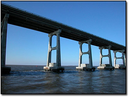
When the dredge Currituck pulled out of Oregon Inlet last Thursday, Nov. 10, the navigational channel under the Herbert C. Bonner Bridge was easily 9 feet deep. By Saturday afternoon, it was about 3 feet, a stunning rate of shoaling even for the notoriously volatile waterway.
“I don’t know what happened,” said Roger Bullock, chief of navigation for the U.S. Army Corps of Engineers Wilmington District. “It was definitely a dramatic change.”
Things were nearly as bad at Hatteras Inlet, where a sailboat, stuck in the shoaled ferry channel, blocked traffic for much of the day Monday. Since the weekend, only the shallow draft ferries and small vessels — when it wasn’t too foggy or the tide wasn’t too low — were able to navigate through the channel.
At least a dozen vessels have hit bottom in recent days, said Dare County Commissioner Allen Burrus, who lives in Hatteras. Most managed to back up or wait to float out. On Monday, he said, there was just over 4 feet of water in the channel, even less the following day. Large ferries draw about 6 feet. Ferry travel back and forth between Hatteras and Ocracoke Island has, by necessity, slowed considerably.
“They’re picking their way, picking their time,” Burrus said. “They’re trying to keep it open.”
Bullock said the dredge Merritt, dispatched from Wilmington, was expected to arrive on Wednesday to start work in Hatteras. The worst spots in the Rollinson Channel are between buoys 9 and 12. It will work for 12 hours a day until Monday, when it will head to Oregon Inlet.
Starting on Nov. 22, the sidecaster dredge will be clearing sand from the channel under the bridge, which is again being clogged by migrating sand on the Bodie Island Spit that had been temporarily swept away by Hurricane Irene.
But the spit’s renewed expansion only partly explains the massive shoaling in the channel. Typically, winter nor’easters dump sand into Oregon Inlet and sand is carried south down the beach by the littoral current. There was a nor’easter a couple of weeks ago, yet it was quiet this past weekend.
To some, the recently-completed beach nourishment project, just north of the inlet, seems to be the logical culprit.
“Somebody ought to call the town of Nags Head and tell them to come get their sand,” said Minta Meekins, general manager of the Oregon Inlet Fishing Center. “You can see where it’s coming from — just go look at the beach in South Nags Head.”
Meekins said that a couple of commercial vessels had bumped bottom on Tuesday, but the charter vessels are still getting out in the deeper water south of the marked channel.
“It’s not stopping us from fishing,” she said.
Steve Shriver, the Corps survey team leader in Wanchese, said that he surmises that the ebb and flow of the powerful currents in the inlet, amped up by the recent nor’easter, may have caused the shoaling over the weekend. The Currituck, a large hopper dredge, he said, had just spent 24 hours a day clearing around the bridge from Nov. 6 to Nov. 10.
“We had good water in the channel at the end of last week,” he said.
The ocean bar currently has about 12 feet of water, and the interior channels have been stable.
Dare County Manager Bobby Outten said that there’s no information he has heard that could attribute the cause of Oregon Inlet shoaling to Nags Head’s nourishment project, especially considering that it would have no relation to Hatteras’ similar woes.
Outten said that the county is “working with anybody who will listen,” to secure funds for more dredging. Recently, he said, coastal counties have begun discussions about collaborating to find ways to afford continued maintenance of their inlets.
“Everybody is scrambling to get dollars that don’t exist,” he said. “We all have the same problem and the solutions aren’t obvious.”
With Washington eliminating the use of earmarks in budgeting, Outten said, Congressional members no longer can readily get funds for local projects into the federal budget. Now, such requests have to work their way into the president’s budget.
“It’s a much more cumbersome process and it doesn’t move quickly,” Outten said.
And federal dredging funds have been slashed not just to the bone, but to the marrow.
Prior to about 2005, the Corps’ budget included about $7.8 million annually for Oregon Inlet dredging, Bullock said. For the last five years or so, it has been $4.5 million annually. For fiscal year 2012, Oregon Inlet was appropriated $1 million. That will cover about 30 days of dredging, he said, plus survey work.
The Corps was able to roll over $1.9 million from 2011 funds, Bullock said, Another $1.5 million in state transportation funds is available for maintenance of the channel to protect the existing Bonner Bridge and during construction of its replacement. In addition, $250,000 was provided in the 2012 budget for dredging Silver Lake and $50,000 for dredging Rollinson Channel.
Bullock said that the state and the Corps are currently hammering out an agreement that would provide regular maintenance dredging for all the ferry channels on the Outer Banks, including Stumpy Point and Rodanthe.
Warren Judge, chairman of the Dare County Board of Commissioners, said that the situation with the Outer Banks’ inlets is symptomatic of Washington’s “collective stalemate.” If the waterways are not maintained, he said, commerce will invariably suffer.
“We’re spending millions of dollars, but we can’t fix the things that need fixing,” Judge said. “Everybody talks about job creation, but the first thing you do is keep the jobs you’ve got.”
FOR MORE INFORMATION
Previous Island Free Press articles on Oregon Inlet shoaling:
http://islandfreepress.org/2011Archives/04.12.2011-FocusOnOregonInletFixForContinualShoalingEludesEvenTheGovernor.html
POSTSCRIPT
Coast Guard warns mariners of shoaling at Oregon Inlet
The Coast Guard warned mariners of shoaling near the center span of the Herbert C. Bonner Bridge at Oregon Inlet on Thursday, Nov. 17.
A survey conducted this week by the Army Corps of Engineers noted water depths as low as two feet in the federal navigation channel that runs through the main bridge span.
Shoaling, driven by the recent nor’easter, has accelerated during the last two weeks with water depths dropping in the channel from 18 feet to less than three feet. Deeper draft vessels are not able to safely navigate the channel and should use alternate routes.
All mariners are urged to exercise extreme caution in the area and limit their transits to high water tidal periods. Continued shoaling may force shallow draft vessels to seek alternate waterways to access the Atlantic Ocean.
For more information, including recent inlet depths, visit the Army Corps of Engineers Web site at http://www.saw.usace.army.mil/nav/.


