Buxton Meeting Highlights Concerns with New-in-2020 Flood Maps
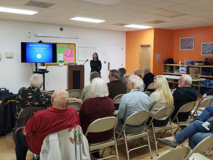
Dare County Planning Department Director Donna Creef touched on some of the major concerns with the new Flood Insurance Rate Maps (FIRMs) at an informational meeting held in Buxton on Thursday evening, February 13.
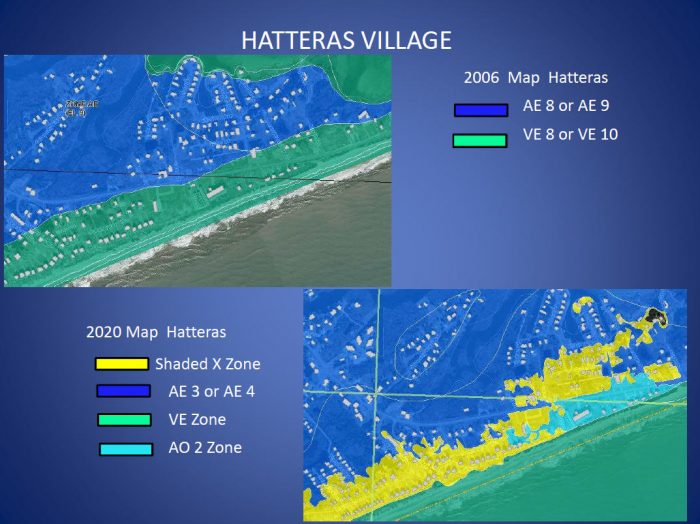
The new flood maps, which will go into effect on June 19, may misrepresent the actual risk of flooding for a number of island homeowners, as many communities on Hatteras Island are moving into less-risky flood zones.
The FIRMs are updated every 10 years or so, and the last update for Dare County was in 2006. Because the process for the federal government to update and implement the maps takes literal years, the new flood maps were created with outdated data, and do not include recent hurricanes or flooding events.
“I think that’s exactly why the maps are the way they are,” said Creef. “[The data] is based on older storms that didn’t affect Dare County the way they affected other parts of the state. They didn’t include Irene, Sandy, Mathew, Hermine – I could name 10 to 12 storms.”
Each home on the flood map is located within a specific zone. The AE zone and VE zone have a 1% annual chance of flooding, and the VE zone represents the highest risk, due to the probability of wave action plus flooding.
The newly created AO zone has a 1% annual chance shallow flooding between 1 to 3 feet, the shaded X zone has a 0.2% annual chance of flooding, and the X zone is the safest zone, and is classified as an area that may receive flooding outside of 500 years.
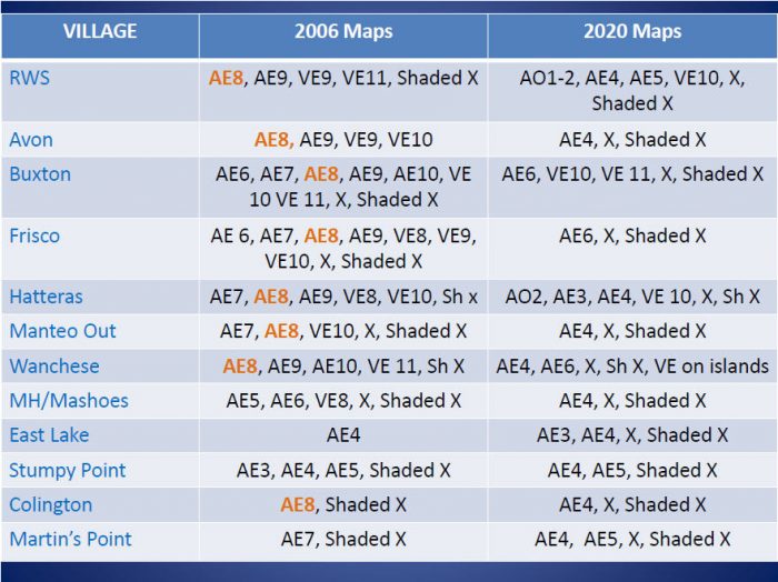
The AE, VE, and AO flood zones are further distinguished with a corresponding number that represents base flood elevation (BFE), like AE8, or AE4. This number refers to where the lowest elevation of a living area can be located. So, for example, a house in an AE8 area would need to have its first living area at 8 ft.
The issue, Creef explained, is that the 2020 flood maps are a big divergence from the 2006 maps, and many homes throughout the county are being moved to a potentially inaccurate flood zone.
The current 2006 maps have 12,875 AE properties and 1,828 VE properties. The 2020 maps only have 8,493 AE properties, (and many with a decreased base flood elevation of AE4 instead of AE8), 120 new AO properties, and just 124 VE properties.
A breakdown of the flood zone changes by village is outlined in detail below.
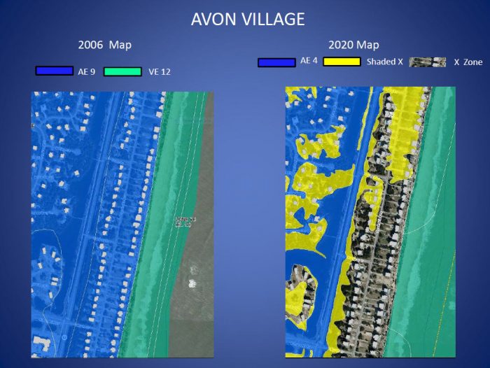
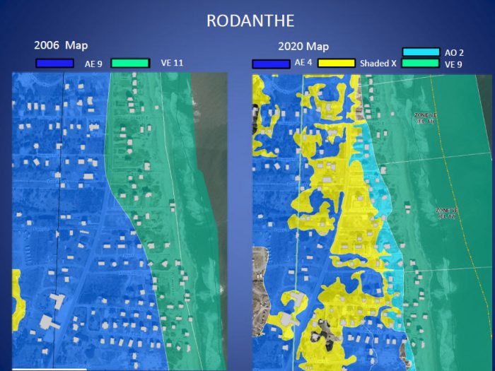
Creef also demonstrated how certain flood zones on Hatteras Island were drastically changing via side-by-side comparisons of 2006 versus 2020 maps for areas that have flooded within the past few years.
In one of the most striking examples, Ocean View Drive in Avon, (which is currently in a AE9 or VE12 zone), is being moved to a AE4, shaded X or X flood zone, meaning that flood insurance may not even be required for certain properties in an area that can be highly susceptible to ocean overwash.
“The message you need to take home today is don’t drop your flood insurance,” said Creef. “FEMA only comes in to help when there’s a declared disaster, and we aren’t always declared a federal disaster [area]… Dorian was not declared a disaster, for example.”
Creef also noted that FEMA assistance often comes in the form of SBA loans that must be repaid, and a requirement to secure flood insurance as part of the assistance.
She also pointed out that 25% of flood claims occur in Shaded X or X zones, and that if the flood maps change again during the next update, (which is likely), homeowners who dropped their flood insurance may be facing higher rates once they obtain it again.
“The elevations in the 2006 maps have been pretty accurate from what we’ve seen,” she said, “so we are doing a big push to [keep or obtain] flood insurance. Flood insurance is important, and especially for folks on Hatteras Island.”
She noted that while Dare County does not have the authority to change the 2020 flood maps, as they are determined on a federal government level, the county is taking steps to create a Flood Damage Prevention Ordinance to be updated in conjunction with the revised maps, which will address building or remodeling projects in Dare County. “The flood maps are used for flood insurance purposes – the flood ordinance is our administrative side of it,” she said.
Due to the big changes and heightened risk for many homeowners, Creef said that the county would be conducting outreach activities to stress the importance of flood insurance through the use of direct mailings, Current TV, and community meetings – all focusing on the slogan of “Low Risk is NOT No Risk.”
In the meantime, Dare County property owners are encouraged to contact their insurance agents about the 2020 maps to discuss potential impacts for their home, and their insurance.
“Do not discontinue your flood insurance coverage, and if you don’t have flood insurance, once the maps are adopted, it may be an ideal time to secure coverage,” she said. “All property owners should talk to their insurance agents about the best possible rate for their property when the maps are adopted… Remember, Low Risk is NOT No Risk.”
To view how your property’s flood zone may be changing in the new 2020 flood maps, visit https://fris.nc.gov/fris/.






I thought Base Flood Elevation is number of feet above sea level not ground level?
Corruption in our face, once again.