National Hurricane Center adding inland watches/warnings to cone maps
The National Hurricane Center (NHC) plans to make what may seem like a minor change to its graphics during the upcoming tropical cyclone season, but they hope it has major implications on how people prepare for a storm.
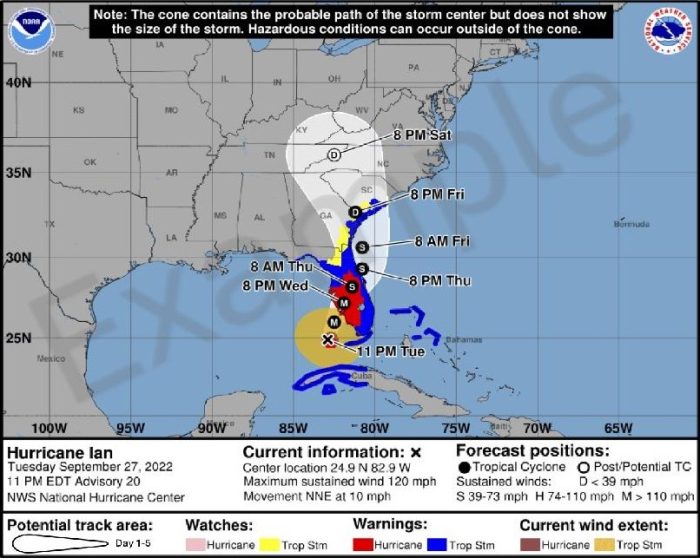
As part of eight updates to the center’s products and services for 2024, the Experimental Cone Graphic will depict inland watches and warnings for the United States beginning on or around August 15.
Previously, the cone graphic only showed watches and warnings in a line along the coastline of the affected area.
The center said recommendations from social science research suggest that the addition of inland watches and warnings to the cone graphic will help communicate wind risk during tropical cyclone events while not overcomplicating the current version of the graphic with too many data layers.
“A recent unpublished study of alternative cone variations found that the inclusion of inland wind risk information on the cone graphic decreased focus on the storm track and increased focus on wind hazard information compared to the versions of the cone without inland watches and warnings,” according to NHC public affairs.
The center is also reviewing additional social science research on the cone of uncertainty and gathering feedback from customers and partners to evaluate other potential modifications to the product.
“The primary goal is to find ways to simply and effectively communicate tropical cyclone risk without making the graphic too complicated,” NHC public affairs noted.
The experimental cone graphic will be available on hurricanes.gov for both full and intermediate advisories.
But the experimental graphic may not be available when advisories are released, because of time needed to compile complete inland watch and warning information from local weather forecast offices of the National Weather Service.
“It should generally be available within 30 minutes of the advisory release,” according to NHC public affairs.
The current operational cone graphic will continue to be available, and there will be no changes with respect to how watches and warnings are displayed on that graphic (i.e., only coastal watches/warnings will be depicted.
During the experimental phase, technical issues could also affect the timeliness or availability of the graphic.
There will be an opportunity to provide comments and feedback during the product’s experimental phase.
An early prototype of the cone graphic with inland watches and warnings:
Another change coming this season is that watches and warnings can now be issued during intermediate advisories.
Previously, tropical storm, hurricane, and storm surge watches and warnings could only be issued for the United States on full or special advisory packages.
Full advisory packages are issued at 5 AM, 11 AM, 5 PM, and 11 PM EDT.
Beginning in 2024, NHC will be able to issue U.S. tropical cyclone watches and warnings with regular or intermediate Public advisories.
Changes to watches and warnings will be reflected in the Tropical Cyclone Public Advisory (TCP) and coastal tropical wind watches and warnings will be reflected on the cone graphics issued with each regular or intermediate Public Advisory (TCP).
An example of the TCP product with tropical watches and warnings issued at the intermediate advisory can be found here: https://www.nhc.noaa.gov/productexamples/Intermediate_Adivosry_w_US_WW_Issuance_Exa mple.txt
Other changes announced for 2024 include:
- Extension of tropical storm (39 mph, 34 kt) and 58 mph, (50 kt) wind radii forecasts to days 4 and 5
- Expanding Spanish language advisory text products
- Weblinks in the Public Advisory that contain pertinent graphical hazard information
- Change to the time zone reference in the eastern Pacific, as most of Mexico no longer observes Daylight Saving Time
- Experimental international tropical cyclone rainfall graphics for the Caribbean and Central America
- New marine forecast product: “Offshore Waters Forecast for the southwestern North Atlantic Ocean” that covers the open ocean from the Florida/Georgia, through the Bahamas to Cuba’s northeast coast to north of Puerto Rico.
The Atlantic hurricane season runs from June 1 to November 30. Tropical cyclone names (with pronouncers) for the 2024 season:
- Alberto “al-BAIR toe”
- Beryl “BEHR-ril”
- Chris “kris”
- Debby “DEH-bee”
- Ernesto “er-NES-toh”
- Francine “fran-SEEN”
- Gordon “GOR-duhn”
- Helene “heh-LEEN”
- Isaac “EYE-zik”
- Joyce “joyss”
- Kirk “kurk”
- Leslie “LEHZ-lee”
- Milton “MIL-ton”
- Nadine “nay-DEEN”
- Oscar “AHS-kur”
- Patty “PAT-ee”
- Rafael “rah-fah-ELL”
- Sara “SAIR-uh”
- Tony “TOH-nee”
- Valerie “VAH-lur-ee”
- William “WILL-yum”
Alternate name lists (used when the 6-year list is exhausted)


