Friday, May 23, 2025

Severe thunderstorms possible on Monday, May 27

Share post:

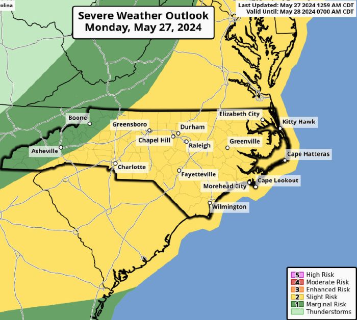
There will be a slight risk of isolated to scattered severe thunderstorms developing across portions of eastern North Carolina on Monday, May 27, per an update from the National Weather Service Newport/Morehead City office.

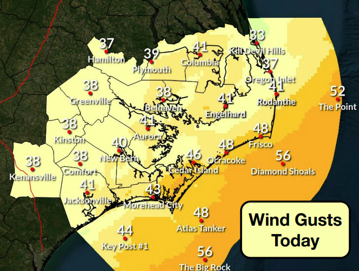
The primary severe risk is damaging wind gusts of 40-70 mph, but hail up to golf-ball size is also possible. There is also a threat of tornadoes, as well as heavy rains.

This is a unique event in that the environment is supportive of higher impact severe weather for eastern North Carolina, but confidence in where/if thunderstorms will form is lower than normal. As such, the public is advised to have multiple ways to receive weather and tornado warnings, if warrented.

For more information on the local forecast, visit www.weather.gov/mhx for weather information, or the National Weather Service office in Newport/Morehead City’s Facebook page at https://www.facebook.com/NWSMoreheadCity/.


Trending

Subscribe

Help Support Local News! Subscribe for Free, Upgrade to Premium, or Make a Contribution.

Related articles

What’s the plan for Ocracoke’s vulnerable South Dock ferry terminal? NCDOT wants public input

Public comments were encouraged at two open-house-style meetings that shared potential solutions to the Hatteras-Ocracoke ferry’s troublesome South...

Cape Hatteras Electric celebrates SHARP renewal at annual meeting with record-breaking attendance

The Cape Hatteras Electric Cooperative (CHEC) had record-breaking attendance at its 80th annual membership meeting, which was held...

Slash Creek Bridge in Hatteras Village opens to traffic

The new Slash Creek Bridge in Hatteras Village opened to traffic on Thursday evening, a day ahead of...

Fessenden Center Gymnasium reopens after completion of roof & siding replacement project

The Dare County Parks and Recreation Department’s Hatteras Island Division has announced that the gymnasium located inside the Fessenden Center (46830 N.C....