Friday, May 23, 2025

Severe thunderstorms possible on Thursday afternoon, June 27

Share post:

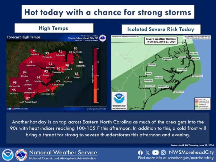
There will be a slight risk of severe thunderstorms developing across eastern North Carolina on Thursday, June 27, per an update from the National Weather Service Newport/Morehead City office.

The highest risk of strong storms will be Thursday afternoon as a cold front approaches the coastline, and the main threats will be damaging wind gusts, hail, and torrential downpours.

Heat Advisories are also in effect for most of the North Carolina coastal plan, with local Outer Banks temperatures forecasted to be in the mid-to-high 80s.

The intense heat and humidity will significantly increase the potential for heat-related illnesses, particularly for those working or participating in outdoor activities

For more information on the local forecast, visit www.weather.gov/mhx for weather information, or the National Weather Service office in Newport/Morehead City’s Facebook page at https://www.facebook.com/NWSMoreheadCity/.

Trending

Subscribe

Help Support Local News! Subscribe for Free, Upgrade to Premium, or Make a Contribution.

Related articles

What’s the plan for Ocracoke’s vulnerable South Dock ferry terminal? NCDOT wants public input

Public comments were encouraged at two open-house-style meetings that shared potential solutions to the Hatteras-Ocracoke ferry’s troublesome South...

Cape Hatteras Electric celebrates SHARP renewal at annual meeting with record-breaking attendance

The Cape Hatteras Electric Cooperative (CHEC) had record-breaking attendance at its 80th annual membership meeting, which was held...

Slash Creek Bridge in Hatteras Village opens to traffic

The new Slash Creek Bridge in Hatteras Village opened to traffic on Thursday evening, a day ahead of...

Fessenden Center Gymnasium reopens after completion of roof & siding replacement project

The Dare County Parks and Recreation Department’s Hatteras Island Division has announced that the gymnasium located inside the Fessenden Center (46830 N.C....