Weather-watching continues through another week
Island residents will barely have a breather between storms, as a nasty cold front is about to park itself off the coast Thursday night through the weekend, bringing more heavy rain and pounding surf.
Meanwhile, Hurricane Joaquin is barreling up the coast towards the Outer Banks, and although it is still uncertain what its track will be, Hatteras and Ocracoke islands will almost certainly experience high seas, soaking rain, strong winds and flooding.
As of 5 p.m., the National Weather Service forecast had worsened for the Outer Banks, showing that the storm had more likelihood of making landfall in the Carolinas and the mid-Atlantic states, and indicated that it would continue strengthening. One model, however, had Joaquin moving northeast and out to sea.
A hurricane watch for portions of the Atlantic coast may be required by Thursday evening, according to the National Weather Service.
On Hatteras Island, Cape Point had reopened on Wednesday, after severe escarpment on the beach, as well as flooded ramps, forced the National Park Service to close the Point over the weekend. Ramp 44 remains closed, but access is available via Ramp 43.
“Our east facing beaches took a beating up and the down the seashore,” said Cape Hatteras National Seashore spokeswoman Cyndy Holda, “and that one was the worst.”
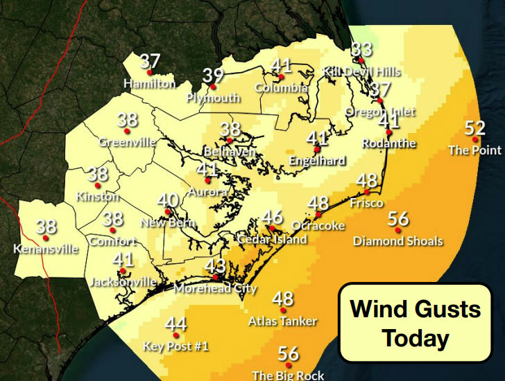
The Hatteras Island Local Emergency Planning Committee met late Wednesday to make damage assessments from the northeaster that just exited the Outer Banks, and to rally the forces for the coming weather.
Hyde County officials will meet Thursday at 5 p.m to discuss preparations for Joaquin. Ocracoke suffered significant flooding on parts of the island during the recent storm.
With the ground already drenched from rain deluges, and the beach chopped up by surging surf during the northeaster, the back-to-back storms are likely to inflict more damage on the weakened environment.
Even without the influence of Joaquin at its heels, the cold front – bringing lots of additional rain and wind – already is expected to be problematic.
“The reason why this is significant,” said National Weather Service forecaster Brian Cullen, “is because it stalls. We’ve still got some pretty high seas out there and they will continue to pound the Outer Banks through the weekend.”
The cold front alone could potentially dump as much as 10 inches of rain on the Outer Banks by Monday.
Further updates on Joaquin will be provided by Dare and Hyde county governments, which are monitoring the weather closely.
The National Hurricane Center forecast has Joaquin’s winds peaking as a major hurricane at 115 miles per hour on Saturday, and the storm staying east of the Outer Banks on Sunday.
But computer models used by forecasters are starting to shift the track and speed of the Joaquin.
“Should the threat to the U.S. increase, any further adjustments of the forecast to the west would likely be accompanied by an increase in the forecast forward speed, with impacts along the coast occurring sooner than currently forecast,” according to the center’s 11 a.m. forecast discussion.
A hurricane watch could be required for portions of the U.S. coast as early as Thursday evening.