Friday, May 23, 2025

Severe thunderstorms possible Wednesday evening

Share post:

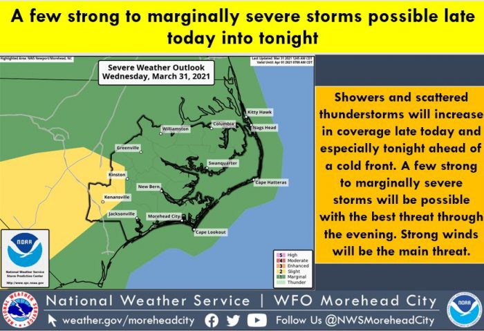
Severe weather is possible on Wednesday evening ahead of a cold front that will bring northerly winds and colder temperatures to the Outer Banks through the weekend, per a recent update from the National Weather Service Newport / Morehead City Office.

Showers and thunderstorms will develop this evening across eastern North Carolina, and a few of the storms could become strong to severe, with damaging winds the primary threat.

The threat of severe weather for the Outer Banks is mainly through the evening until around midnight, although scattered showers are also possible on Thursday morning, and the much colder temperatures will linger behind the cold front through the end of the week.

For more information on the local forecast, visit www.weather.gov/mhx for weather information, or the National Weather Service office in Newport / Morehead City’s Facebook page at https://www.facebook.com/NWSMoreheadCity/.

Trending

Subscribe

Help Support Local News! Subscribe for Free, Upgrade to Premium, or Make a Contribution.

Related articles

What’s the plan for Ocracoke’s vulnerable South Dock ferry terminal? NCDOT wants public input

Public comments were encouraged at two open-house-style meetings that shared potential solutions to the Hatteras-Ocracoke ferry’s troublesome South...

Cape Hatteras Electric celebrates SHARP renewal at annual meeting with record-breaking attendance

The Cape Hatteras Electric Cooperative (CHEC) had record-breaking attendance at its 80th annual membership meeting, which was held...

Slash Creek Bridge in Hatteras Village opens to traffic

The new Slash Creek Bridge in Hatteras Village opened to traffic on Thursday evening, a day ahead of...

Fessenden Center Gymnasium reopens after completion of roof & siding replacement project

The Dare County Parks and Recreation Department’s Hatteras Island Division has announced that the gymnasium located inside the Fessenden Center (46830 N.C....