Study: Climate Change Key in Cycle of Floods
Analysis of nearly 120 years of tropical storm and hurricane landing data and associated rainfall in coastal North Carolina shows that climate change is creating a feedback loop that suggests increasingly frequent flooding and economic damage are likely along the coast.

That’s a general conclusion of research led by Hans Paerl, Kenan Professor of Marine and Environmental Sciences at the University of North Carolina Chapel Hill Institute of Marine Sciences. The research findings and conclusions were in the paper, “Recent increase in catastrophic tropical cyclone flooding in coastal North Carolina, USA: Long-term observations suggest a regime shift,” published July 23 in Nature Research’s Scientific Reports.
The study’s authors stress that officials and stakeholders “need to better prepare for the acute as well as cumulative water quality, fisheries resource and overall socio-economic effects of this recently-documented rise in catastrophic flooding associated with elevated tropical storm activity.”
The rainfall data, compiled by the National Oceanic and Atmospheric Administration, show that six of the seven highest precipitation events since 1898 have occurred within the last 20 years, Paerl said in a recent interview.
Those events include hurricanes Floyd in 1999, Matthew in 2016 and Florence in 2019. Those three resulted in abnormally large floods, Paerl said, and the chance of that happening such a short time frame is less than 2%.
As he writes in the paper, “… either North Carolina has been very unlucky, or the historical record used to define the storm statistics is no longer representative of the present climatic regime.
“This analysis suggests that the occurrence of three extreme floods resulting from high rainfall tropical cyclone events in the past 20 years is a consequence of the increased moisture carrying capacity of tropical cyclones due to the warming climate.”
More CO2 washes to sea, escapes to atmosphere
So, what are the ramifications for our estuarine and coastal ecosystems? Paerl said that receiving ecosystems are becoming overloaded by the frequency of the rainstorms and the sheer amount of rainfall, as well as the nutrient- and organic matter-laden runoff from the watersheds of the Neuse River estuary and Pamlico Sound.
Although the study was not meant to be predictive, he said, the increased runoff means more organic, carbon-based materials enter from the watersheds and are broken down into carbon dioxide, or CO2, by aquatic microbes. As a result, he said, “more CO2 is generated and reenters the atmosphere.”
The process adds to CO2 levels that already are in part responsible for heating the planet and resulting in the likelihood of even stronger and more frequent tropical storms and other rainstorms. It’s a major “feedback loop,” Paerl said. And since the effects can last for months, there is less time for ecosystems to recover — a scenario of increased frequency of storms with higher rainfall content.
“Evidence is accumulating that we may also be seeing changes to the ‘system state’ of coastal waters in terms of their ability to capture or release CO2,” Paerl writes. “Such changes caused by an increased frequency of extreme storm events are ostensibly reorganizing coastal carbon cycles.”
Paerl cites as examples flood waters reaching the inner shelf of the Gulf of Mexico that have resulted in extensive degradation of terrestrial organic matter and the return of that carbon as CO2 to the atmosphere. This bio-geochemistry is linked to water quality.
“Floodwater-associated nutrients have been shown to promote harmful algal blooms in these systems,” according to Paerl. “Floodwaters contain contaminants and runoff from urban and agricultural land use, and due to their high organic load, flood waters often lead to hypoxic (low in oxygen) conditions when they enter an estuary. This is evident in the low (dissolved oxygen) values in the upper (Neuse River estuary) following each storm.”
Also, the big flows of freshwater lead to an “oil and vinegar” situation, with the relatively light freshwater sitting on top of the denser saltwater. “This reduces vertical mixing and organic matter is ‘trapped’ in the denser, salty bottom water, causing extensive hypoxia in bottom waters extending throughout the estuary. These hypoxic events can last weeks to months and provide the ingredients for massive finfish and shellfish kills, as well as an abrupt increase in fish disease.”
All of these things – fish and shellfish kills, floods and more frequent and stronger tropical events – pose serious threats to coastal North Carolina residents and the economy, the study finds. That includes severe economic and societal implications for fisheries, tourism and real estate, in addition to increased concerns about coastal resiliency and sustainability.
In North Carolina, Hurricane Floyd in 1999 caused fisheries losses of $6 million and tourism losses, property and business damage and losses in agriculture and forest management losses amounted to $2 billion.
Analysis of Florence’s longer-term impacts are continuing, the study finds, and while the hydrologic, nutrient and carbon inputs attributable to Florence are yet to be fully tallied, the rainfall associated with the storm was roughly equivalent to Matthew in 2016.
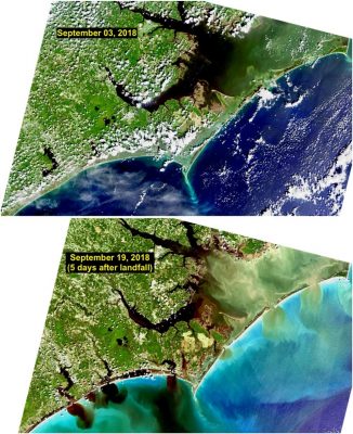
As with Floyd and Matthew, Hurricane Florence’s floodwaters led to “freshening” and expanding hypoxic zones in the Albemarle Pamlico system, with “massive pulses of carbon” overflowing into adjacent coastal waters, as was observed from space. The effects can linger for months after a storm, Paerl added.
“Rather than attributing a particular event to global warming, we should consider whether a warming climate made these events more likely, which our records suggest is the case for coastal NC.”
— Paerl, et al.
And, he noted in the interview, none of these storms were classified as “major” hurricanes – Category 3, 4 or 5 – when they made landfall and affected North Carolina. Floyd was a Category 2, while Matthew and Florence were both Category 1 storms, yet they carried enough rainfall to cause massive flooding.
“Rather than attributing a particular event to global warming, we should consider whether a warming climate made these events more likely, which our records suggest is the case for coastal NC,” Paerl writes in the report.
Examples of this change include the increased precipitation in other coastal areas, including the Texas coast during Hurricane Harvey in 2017. Increased hurricane activity since 1970 has also been attributed to global warming.
Factors driving the increased precipitation include hotter ocean waters, a condition that not only fuels storm intensity but also increases precipitation, and slower forward movement of tropical cyclones, which means heavy precipitation lingers over a particular area, as seen on the North Carolina coast during Florence. Also, an observed poleward migration of tropical cyclones could make coastal North Carolina more vulnerable than in the past. Increased tropical cyclone intensity is another factor.
Ocean temperatures in recent years “have broken all sorts of records” in both the Atlantic and Pacific basins, Paerl said.
Additionally, the world’s population – and North Carolina’s – is growing, further increasing use of carbon-based fuels that contribute to climate change and increasing the amount of hardened surface on land, fomenting more runoff. North Carolina’s population in 1990 was 6.6 million, and by 2018, according to the U.S. Census Bureau, it was 10.3 million.
So what, if anything, can be done?
Paerl said it has become increasingly evident that we need to reduce emissions of greenhouse gases. Also, as individuals, he said, we can reduce the harmful effects of flooding by “not developing” properties “down to the water’s edge,” instead keeping or putting in vegetative buffers that help filter out pollutants before they reach creeks, rivers and estuaries.
Farmers, he said, have done a better job in recent years of maintaining riparian buffers, but city planners and state leaders need to increase their efforts along those lines as well. If we must use them, fertilizers need to be applied at rates just enough for crop production, while avoiding excesses.
“We should minimize fertilizer application during hurricane season; one wet storm can lead to major losses of fertilizer to downstream, nutrient-sensitive waters,” he said.
To limit property and economic damage when floods occur, Paerl said, we should cease building in flood plains.
“There’s a reason flood plains are called ‘flood plains,’” Paerl said, noting that the term refers to areas more likely to flood often. Rebuilding in flood-prone areas should be carefully considered and at least limited, he said.
The extreme precipitation and the resulting effects are clearly unparalleled in the past 120-plus years of recorded tropical cyclones in coastal North Carolina, Paerl writes. “The potential exists for receiving waters globally to undergo unprecedented perturbations to nutrient and carbon cycling, fisheries habitat and sustainability due to increasing frequency of extreme precipitation events; all of which are still to be determined.”
And with roughly 40% of the world’s population within 100 kilometers of the coast, development inland, as well as along the coastline, will exacerbate the problems, Paerl writes. “We stress that stakeholders, state and federal governments need to better prepare for the acute as well as cumulative water quality, fisheries resource and overall socioeconomic effects of this recently-documented rise in catastrophic flooding associated with elevated tropical storm activity.”
Others listed as authors of the report are Nathan S. Hall, a research assistant professor at UNC-IMS; Alexandria G. Hounshell, a UNC-IMS grad student; Rick Luettich, UNC-IMS director and professor; Karen L. Rossignol, a research specialist in the Paerl Lab; Christopher L. Osburn, a researcher and professor at N.C. State University; and Jerad Bales, chief scientist for water at the U.S. Geological Service.
Funding for the research came from the National Science Foundation, the state Department of Environmental Quality, the Lower Neuse Basin Association, North Carolina Sea Grant and the UNC Water Resources Institute.
Learn More
Neuse River Estuary Modeling and Monitoring Project


