This week the Department of Transportation had open houses and hearings on the Outer Banks on its alternatives for bridging an unstable area on Highway 12 prone to overwash and breaches in north Rodanthe and the S-curves area, known as Phase IIb of the Bonner Bridge Project.
Last month, the DOT released an Environmental Assessment (EA), which documents the planning and environmental studies that went into its search for a long-term solution for this highway ?hot spot,? where an inlet opened after Hurricane Irene in 2011 and ocean overwash is common even in northeasters.
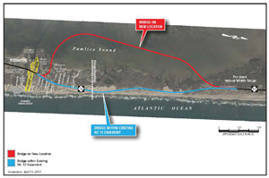
Two alternatives were chosen to be studied in detail ? a 2.5-mile bridge that would be built in the existing Highway 12 easement and a 3-mile bridge that would extend out into the Pamlico Sound from Pea Island National Wildlife Refuge and northern Rodanthe.
The bridge within the existing easement is the department?s chosen alternative because, DOT officials say, it is the choice that will require no new easements and will have the least environmental impact on the Pamlico Sound. In other words, it is the one that can be built the most quickly and easily.

About 90 people signed up at the open house on Wednesday afternoon, Jan. 8, in Rodanthe, and 80 signed up for the formal hearing on Wednesday evening in Buxton. Some attended both the open house and the hearing.
Fewer folks attended an open house in Ocracoke on Tuesday and an open house and hearing in Manteo on Thursday.
There were 10 speakers who gave public comments on Hatteras Island, and many fewer than that at the other sites.
From those public comments and conversations with people who attended but didn?t comment, it seems that there is, so far, not a clear majority coalescing around either option. If anything, folks seemed to prefer the Pamlico Sound bridge alternative.
Furthermore, a splinter group of homeowners, business owners, and residents feel that neither option is feasible and that DOT should further study beach nourishment.
Beach nourishment was one of the options that DOT chose not to pursue for the EA because of the uncertainties about sources of sand over the project?s 50-year life and that it would not be found compatible with the refuge?s mission and purpose.
Public comment will be accepted until Jan. 24. See information at the end of the blog for commenting.
THE CHOICES

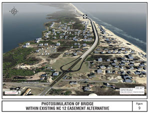
The bridge within existing easement alternative, DOT?s preference, would place the new bridge within the current Highway 12 right-of-way.
Other details:
- It would be an improvement of about 2.5 miles with a 2.3 mile bridge for the southernmost part of the refuge into north Rodanthe.
- It would bridge the area considered most susceptible to breaches and shoreline erosion.
- In the refuge, the surface road would be removed. In Rodanthe, one-way service roads would provide access to private properties and businesses.
- The bridge would be elevated to a height of about 26 or 27 feet. It would have ?a substantial visual presence? in the Mirlo Beach subdivision. People in homes less than 100 feet from the bridge would see traffic passing by out of third-floor windows.
- This alternative would require five residential and two business relocations.
- It would cost between $187.5 and $215.5 million.
- It will be a design-build project.
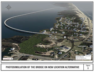
The other alternative with a bridge at a new location would take a 3-mile bridge out into the Pamlico Sound ? 1,400 to 1,700 feet from shore. It would be about 15 feet above mean high water, not as tall as the preferred alternative.

Other details include:
- It would leave the refuge, requiring an easement change, and would reconnect to the existing Highway 12, just north of the Island Convenience store.
- The existing highway from the north end of the bridge to the southern border of the refuge would be removed.
- In Rodanthe, the existing highway would be retained to provide access to private properties.
- The Pamlico Sound Bridge would involve the relocation of two businesses and two homes.
- This alternative would cost about $203.3 to $236.3 million.
- It would also be a design-build project.
Both alternatives would be paid for by federal and state funds. The state funds are already allocated in the current State Transportation Improvement Plan, which runs from 2012 to 2018,
Construction of the bridge in the current easement is estimated to take two to three years, and the Pamlico Sound bridge could take from 3 to 3.5 years.
Costs include construction, right-of-way acquisition and relocations, and utilities relocations.
THE IMPACTS
Scott and Martha Midgett Caldwell are Rodanthe business and property owners who probably have the most at stake in this project.
The couple manages several businesses in north Rodanthe that were established by and have been owned for years by her family.
Island Convenience is a sort-of landmark on Hatteras. It?s the first place many folks stop headed south and the last place that many stop headed north for gas, food, and many other items. It?s the only store open year-round in the tri-villages.
The property also includes a campground and another building with a now-closed restaurant and an auto repair business.
The Caldwells will not lose any of their properties under the option in which the bridge is built in the current easement, but all would have to be relocated and would be off Highway 12. Gas storage tanks would have to be dug up and relocated.
?It?s not worth it,? Scott says.
Under the Pamlico Sound alternative, which they prefer, they would lose property. Gone would be the campground, two residential rental houses they own, and the commercial building with the restaurant and repair business.
However, they would save the Island Convenience store, their main source of income and a business important to year-round residents and visitors.
?Of the two options, both are bad for us,? he says. But he thinks that the business can survive under the Pamlico Sound option.
He and his wife also believe the bridge within the existing right-of-way would be a less than appealing entrance to Hatteras Island for visitors.
Other residents and property owners seem split on their preferred alternative.
Mirlo Beach property owners do not favor either and have started the ?beaches not bridges? movement, which advocates for beach nourishment.
These tall, expensive houses have spectacular views of not only sunrise over the ocean but sunset over the sound.
Any bridge is going to have an impact on those views, especially a bridge in the current easement. Would you want to be on vacation and look out of your top floor windows at the vehicles and trucks going by?
And they say that even the Pamlico Sound bridge will mess up their views.
Their property values could take a big hit either way.
They favor nourishment for that reason ? and more.
The ocean is encroaching on the houses right on the beach. A bridge with no nourishment will mean they stand to lose their homes to the sea, as others before them have.
Other residents and property owners seem to agree that between the two bridge alternatives, the sound bridge will be the more esthetically pleasing and detract less from the gateway to Hatteras Island.
Both alternatives also have implications for recreation in both the sound and the ocean ? for windsurfers, kiteboarders, surfers, and fishermen.
Click here to see a chart comparing DOT?s analysis of the impacts of each option.
THE BOTTOM LINE
The bottom line is that we need a reliable transportation corridor and we need it now.
?It?s been a tough two or three years,? said Scott Caldwell. ?Time is of the essence.?
There are plans to nourish northern Rodanthe beaches.
The U.S. Army Corps of Engineers will do an emergency nourishment project to repair erosion damage caused by hurricanes Irene and Sandy. The time table for doing that has dragged on, but it will hopefully be completed this year.
Also, Dare County plans to nourish beaches in north Rodanthe and north Buxton.
That project is active and underway, though getting it done with permitting, funding, and finding sand sources is probably several years away.
If DOT switches from either of the bridge options to nourishment, we are looking at a lot more time than just the two or three years to build a bridge.
It?s time we don?t have.
The money for either bridge is in the state?s Transportation Improvement Plan, but how money is allocated for transportation projects in the state has changed under the current Republican administration. The new formula does not favor rural or coastal counties.
If there isn?t a project underway this year, we could well be without the state money we need.
The ?beaches not bridges? movement is misguided and could cost us a viable transportation corridor in a timely manner.
Beth Midgett said it best in a commentary she wrote for the Bridge Moms Facebook Page.
?It?s not a choice between beaches or bridges,? she wrote. ?We need both!?
You can submit comment to DOT until Jan. 24.
We all need to weigh in.
FOR MORE INFORMATION
Click here to see the very lengthy Environment Assessment of the project.
Click here to see the summary of the project in the handout prepared for the public meetings with information about submitting comments.
Click here to read Beth Midgett?s commentary.
Click here to go to the Beaches not Bridges website, beachesnotbridges.org.


