Hurricane resources to download, bookmark or utilize now
With confidence continually increasing that Hurricane Dorian will have impacts on the Outer Banks, now is the time for residents and visitors to make final storm preparations, which includes pinpointing online and / or mobile resources for area information as the storm progresses.
The following apps and online tools were recommended by the National Weather Service (NWS) and Dare County at a Hurricane Community Forum in Buxton held in July, and are readily available to the public to obtain updates as Dorian approaches.
The Island Free Press will also continue to post updates directly from the National Weather Service, county and state governments, the Cape Hatteras National Seashore, and other trusted sources as they become available.
ReadyNC App
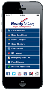 The ReadyNC mobile app is a statewide and all-in-one tool “to help people get ready for everything from traffic jams to hurricanes and ice storms,” per the app’s online description. The free app works with both iPhone and Android phones, and features a wealth of information that covers all aspects of hurricane preparation and recovery.
This includes but is not limited to the following:
- Current weather conditions
- Open shelters near you, (including ones which accept pets)
- Flood gauges that work with the recently installed gauges on Hatteras Island
- Real-time traffic conditions
- Evacuation information and counties being evacuated
- Tips and information on creating an emergency plan
- Post-storm resources and who to call for help when a disaster strikes
The app was created by the N.C. Department of Public Safety and North Carolina Emergency Management, and is an all-encompassing resource for all hurricane-related info that is especially useful when residents and visitors are on the go, and are potentially miles from home during an evacuation. For details, visit https://readync.org/.
Emergency Alerts System
 In the past several years, Dare County Emergency Management has established a system that shares alerts on potentially dangerous or emergency situations.
Featuring three ways for the public to sign up and / or receive this information, the system allows the county’s Emergency Management team to share valuable info including evacuation orders and reentry information, hurricane advisories, bulletins, and post-disaster information for Dare County.
Registered users pick how time-sensitive messages are received and which devices, phone numbers, and email addresses notifications are sent to, and can also select which alerts they would like to receive from NOAA and the National Weather Service.
For more information and to sign up, visit https://www.darenc.com/departments/emergency-management/emergency-alerts, and remember that you can also obtain warnings and alerts on beach conditions like rip current risks by texting “Join OBXBeachConditions” to 30890.
Storm Surge Hazard Maps
For the past few years, there has been an increased focus by the NWS on storm surge versus hurricane category, (which gauges wind speeds), when it comes to estimating how much damage a storm is going to cause.
In response to this shift in focus, interactive storm surge / flooding maps were introduced via the National Hurricane Center during Hurricane Arthur in 2014, and the maps have been steadily improving ever since, with new data and information garnered with every storm.
Interactive maps are now available with every named storm, including Dorian, on the National Hurricane Center’s website along with other affiliated and online products, such as the Cone graphics, Wind Speed Probabilities, and Arrival Time of Winds.
The maps show what to prepare for via a color-coded estimate of expected flooding, (like “less than 3 feet above ground” or “greater than 3 feet above ground,” etc.) Considering that storm surge is forecast to be a possible issue for the Outer Banks, the Storm Surge Hazard Maps should be carefully reviewed while making plans.

For more information:
- For preparedness information, visit readync.org.
- Monitor local weather reports at weather.gov/mhx, sign up to receive alerts directly from Emergency Management at www.darenc.com/alertsand follow @DareCountyEM on Twitter.
- For evacuation information, see Dare County Emergency Managementand Hyde County Emergency Management.


