The Island Free Press gets a good deal of mail from readers — questions, comments, and suggestions. I try to answer or acknowledge all of it.
Sometimes, the questions or comments lead to an article, but often they don’t — even though they might be of interest to more of our readers.
Today, I thought I would try something new and devote my blog to mail from readers — a sampling of comments and suggestions that all of you might like to read about.
PEDESTRIAN CROSSWALK
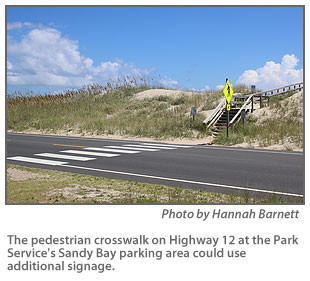
Bill Barley of Buxton emailed me this week about the pedestrian crosswalk on Highway 12 between Frisco and Hatteras village at the Park Service’s Sandy Bay parking area. The area provides parking for folks who want to use the soundside beach and, across Highway 12, there is a stairway over the dunes to the ocean beach.

“I travel the road frequently in my work,” Barley wrote, “and have seen multiple instances where there could have been a terrible accident between people trying to cross to the steps over the dunes and vehicles traveling the posted speed limit of 55 mph and higher. It almost happened as recently as this morning as I was traveling south.”
The crosswalk is a concern to many of us who travel this stretch of highway regularly. Every time I stop to let pedestrians cross, I pray that the folks going 55 behind me will see that I have stopped and not plow into the back of my vehicle.
Barley observes:
- North Carolina law provides that vehicles must stop for pedestrians within a crosswalk. Obviously, most motorists are not aware of this fact. If you travel the beach road from Nags Head northward, the majority of crosswalks bear not only the large pedestrian crossing sign but a smaller placard below notifying motorists of the rule.
- With the possible exception of Canadian Hole, the other crosswalks are within village limits with much lower speed limits and no passing zones. The crosswalk in question is in a 55 mph zone and is in a passing allowed zone, which means the passing vehicle will more than likely be traveling in excess of the posted speed limit. An accident at that speed would be a disaster. Visibility for the passing vehicle is greatly reduced.
- Next time you travel through there take note of the visibility when you are traveling at the posted speed limit. Going south there are two signs leading up to the crosswalk (“No Parking” and “High Water”) and sea oats growing along the edge of the road, which makes it hard to see ahead at that rate of speed. Going north, the stairs end almost on the pavement and sea oats there block your view of the stairs until you are almost upon them.
And Barley has a suggestion for the North Carolina Department of Transportation.
“It seems DOT could post additional signage further away alerting motorists to the approaching crosswalk,” he writes.
I sent Barley’s email to Nicole Meister, a DOT spokesperson, and she replied promptly.
She wrote that she spoke to Jason Davidson, the division traffic engineer, and he is going to coordinate with the Dare County maintenance office to take a look at the location.
“Thank you for passing this along to us,” Meister wrote, and she provided a webpage on which citizens can notify DOT of problems and issues and ask questions. It is https://www.ncdot.gov/contact/ .
We will check back with NCDOT if we don’t hear from the traffic engineer.
BIKE LAWS
Last month, a reader called to say that we should do something to publicize North Carolina’s bike laws.
Bicyclists are plentiful along Highway 12 — the Outer Banks Scenic Byway — especially in the summer time, and this reader thought perhaps out-of-state bikers might be unaware that bicycles are required to travel in the right lane — moving in the same direction as the traffic. It is unlawful to ride against the traffic.
There is a “sort of” wide shoulder along Highway 12 to accommodate bicyclists, but it’s still a tight squeeze in most cases, and most vehicles try to move slightly to the left to give the bikers plenty of room.
I was reminded of the law that bikes must use the right lane the other day when I was driving on the road and encountered bikers traveling in both directions of the highway. Vehicles in both directions were trying to move over to give the bicyclists some more room — not a good situation!
Also, in North Carolina, bicyclists under 16 must wear a helmet.
And if you are staying in one of the villages and using your bike to go out for the evening, remember that in North Carolina, bicycles are considered vehicles and impaired driving laws apply to bicyclists, as well as drivers of motor vehicles.
SALTY PUDDLES

One last note on roadways and driving.
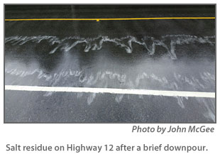
Recently, John McGee of Frisco sent us a photo of what he said was salt residue on Highway 12. He said it was taken after a week of no rain and then a very brief downpour.
He used it to make the point that even the rainwater on the highway is salty on Hatteras and Ocracoke and to make a plea to visitors.
“You think it’s rainwater, but it’s actually saltwater,” he wrote. “Drive slowly through it and don’t spray us down.”
CEMETERY PRESERVATION

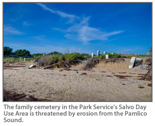
Jeanine Batchelor, a reader who lives in Silver Spring, Md., was in touch with us about the erosion that is threatening the old family cemetery in the National Park Service’s Salvo Day Use area.
She said she and her family have been visiting the Outer Banks for decades and on a recent trip to Salvo read an article about the cemetery.
The little cemetery has become a historic and cultural site. As a family cemetery, it dates back to 1872, primarily for the Midgett family initially.
When the Park Service established the Salvo Campground, which became today?s Salvo Day Use Area, the cemetery remained private property, just like the rest of the village. That means all funding for repairs must come from non-federal sources.
Today, the condition of the cemetery is shocking to many locals and visitors, and many want to help.
“I will be returning to Salvo on my own for a week in November,” Jeanine writes in her email to me, “and would like to contact someone to ask if there is any kind of work I can volunteer to do while I am in the area. Unfortunately, I am at a loss as to whom to contact.”
Leading the effort to save the cemetery is Jenny Creech, president of the Hatteras Island Genealogical and Preservation Society.
The group has a Facebook page, where there are often updates on the cemetery. Jenny can also be reached by email at jfc_hgsoc@yahoo.com.
Contributions are welcome, and several local groups are sponsoring a traditional island dinner to raise funds for sandbags for the cemetery. The event will be on Friday, Aug. 26, from 3 until 7 p.m. at the Rodanthe-Waves-Salvo Community Building.
The dinner will include traditional island fare — chicken and pastry, Hatteras-style clam chowder, potato salad, collards, and more. The suggested donation is $10 per dinner.
If you happen to be on Hatteras on that date, I am sure you will love the island version of chicken and dumplings. It’s really good!
BUXTON BEACH NOURISHMENT
A reader whose family has been renting oceanfront accommodations in Buxton for many years wonders about the schedule for beach nourishment in the area next year.
Dare County is planning a $25 million project to nourish about 2.9 miles of beach from about the Canadian Hole/Haulover area to the former site of the Cape Hatteras Lighthouse. The goal of the nourishment is to protect Highway 12 from the encroaching Atlantic Ocean.
The contractor for the county will use sand from an offshore borrow pit and pipe it onto the beach in the area to make it wider.
The reader who contacted us wanted to know if there was a schedule yet for the project and if he needed to make changes to his summer plans.
The answer is that the contractor has not announced a schedule yet. However, it’s a good bet that some of the project might happen in the summer months when the ocean tends to be calmer and easier for the equipment to work in.
So what should folks who are planning vacations next summer do?
Probably, just continue with their plans.
The N.C. Department of Transportation nourished the beach in north Rodanthe and the S-curves on Pea Island in the summer of 2014.
Real estate managers said they had few complaints from guests in their cottages during that project.
Only a small part of the Rodanthe project involved the beach in front of rental houses — as will be the case in Buxton, where it will include beach in front of cottages and three motels.
The equipment moved really fast in the Rodanthe project and was not in front of any rental for an entire week.
Some renters found it interesting enough to take photos and send them to The Island Free Press.
Stay tuned for more details.


