Firefighters making progress on wildfire, but smoke may return to Hatteras and Ocracoke
By IRENE NOLAN
By IRENE NOLAN
Hatteras and Ocracoke islands have largely been spared by the heavy smoke this week from the Pains Bay wildfire in the Alligator River National Wildlife Refuge on the Dare County mainland.
However, that could be changing tonight.
The fire was ignited on Thursday, May 5, by lightning. Other causes were being looked at last week, but investigators decided last weekend that lightning was indeed the cause.
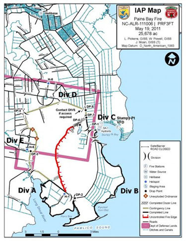
The wildfire spread quickly in the first days because of windy conditions and low humidity. At one point, it threatened the mainland village of Stumpy Point, which is now considered safe.
From Sunday, May 8, through Tuesday, May 10, the smoke was thick, acrid, and oppressive on Hatteras and Ocracoke.
But a shift of the winds to an east, south, and then southwest direction has sent the smoke away from the islands and toward various other locations – from Raleigh, to Hampton Roads, to the northern Outer Banks.
Tonight, after midnight, the wind is forecast to shift to a more northerly direction.
According to forecaster Bel Melendez at the National Weather Service office in Newport, N.C., the wind will be from the northwest tonight and tomorrow morning with a shift to the north in the afternoon.
That will bring the smoke toward Hatteras and Ocracoke, though it may not be as intense as it was last week.
The North Carolina Department of Environment and Natural Resources Air Quality Division has issued a code orange air quality action day alert for fine particulates in the air on Saturday, until 3 p.m., for Outer Banks Dare and Hyde counties, mainland Dare, and Tyrell County.
Melendez said by Sunday, the wind will be from the southeast and the smoky conditions should improve.
A national incident team brought in to fight the fire last week was replaced this week with a North Carolina incident team.
The acreage of the fire has not changed much from the weekend and remains at about 25,600 acres. It is about 80 percent contained.
In addition, the fire has been burning underground since late last week – smoldering deep in the peat layers under the refuge. Last night, the peat ground fire involved 3,711 acres.
Firefighters have been irrigating – or pumping water – onto the ground fire for a week and are making progress.
This afternoon, the peat fire was down to about 3,400 acres, said Chris Carlson, public information officer for the North Carolina Division of Forestry. He said he hoped it that number would drop to 3,000 acres by this evening.
However, fire officials have noted that the peat fires can burn, perhaps for months, especially without some kind of soaking rainfall from a tropical system.
A 10-mile stretch of U.S. 264 remains closed between Stumpy Point and Engelhard. A large number of engines are working on the roadway to extinguish the ground fire. Specialized irrigation equipment and helicopters are also operating close to the roadway.
Fire officials determined that these operations created a safety hazard to both firefighters and the public requiring closure of the road.
Carlson said that completing the work along the highway remains a high priority so that the road can be opened as soon as possible, but he couldn’t estimate yet when that would be.
Operations at the fire site today concentrated on soaking the ground fire on the northeast perimeter and dealing with hotspots along the highway on the southern perimeter.
Warm and dry conditions continue to hamper efforts to stamp out the fire, Carlson noted, and there is little or no rain in the forecast for the next week.
About 180 personnel are involved in fighting the fire, along with 11 tractor/plow units, 13 engines, and three helicopters.
Officials estimate that the cost to fight the fire so far at about $2.7 million, which includes hotel rooms for personnel from around the state and across the country and equipment.
Involved in fighting the fire are the U.S. Fish and Wildlife Service; North Carolina Division of Forest Resources; U.S. Forest Service; National Park Service; Department of Defense – Air Force; Bureau of Land Management; Bureau of Indian Affairs; state forestry agencies, including Colorado, Florida, Indiana, Maine, Montana, and Virginia; Stumpy Point, Manns Harbor, and Roanoke Island volunteer fire departments; and Dare County Emergency Management Services.
FOR MORE INFORMATION
Smoke advisories for the area can be found at: www.weather.gov/mhx and more information on air quality is available at www.ncair.org/airaware/forecast/
Additional information on the fire, including announcements, photos, and maps can be found by visiting Inciweb http://www.inciweb.org/incident/2218/ or Facebook http://www.facebook.com/pages/NC-Division-of-Forest-Resources/117366861613343
Live satellite imagery of the smoke plumes be found at http://www.ssd.noaa.gov/goes/east/wfo/mhx/flash-vis.html
Previous Island Free Press articles on the wildfire:
http://www.islandfreepress.org/2011Archives/05.06.2011-WildfireGrowingLargerInAlligatorRiverNationalWildlifeRefuge.html
http://www.islandfreepress.org/2011Archives/05.10.2011-UPDATEFirefightersMakeProgressAgainstDareMainlandWildfire.html
http://www.islandfreepress.org/2011Archives/05.13.2011-UpdateHatterasAndOcracokeAreLessSmokyButConcernNowIsGroundFire.html
Subject
Name
(required, will not be published)
(required, will not be published)
City :
State :
Your Comments:
May be posted on the Letters to the Editor page at the discretion of the editor.
May be posted on the Letters to the Editor page at the discretion of the editor.
May be posted on the Letters to the Editor page at the discretion of the editor.
May be posted on the Letters to the Editor page at the discretion of the editor.


