Latest watches, warnings, and local Hurricane Irene statements at http://www.erh.noaa.gov/er/mhx/ MORE DARE COUNTY INFORMATION The Dare County Control Group has activated the Joint Information Section (JIS) in response to Hurricane Irene. All information regarding local government agencies in Dare County will be released through this source effective today, Wednesday, Aug. 24. The JIS is a collaborative organization that encompasses the six municipal governments in Dare County, the National Park Service, the Dare County Sheriff’s Office, and the County of Dare, all of which have representatives on the Dare County Control Group. The JIS is operated in the Emergency Operations Center (EOC) in Manteo and managed by Dare County Emergency Management. Outlets for information include the following: The Dare County website at www.darenc.com Government Access Channel 20, Charter Cable Channel 20 Releases e-mailed and faxed to local, regional, and national press outlets Emergency Management Public Phone Inquiry Line at 252-475-5655 Other Important Numbers:
By IRENE NOLAN
By IRENE NOLAN
The Dare County Control Group issued a mandatory evacuation order for all residents, beginning at 8 a.m. Friday, Aug. 26.
The Dare County Control Group issued a mandatory evacuation order for all residents, beginning at 8 a.m. Friday, Aug. 26.
The Dare County Control Group issued a mandatory evacuation order for all residents, beginning at 8 a.m. Friday, Aug. 26.
The Dare County Control Group issued a mandatory evacuation order for all residents, beginning at 8 a.m. Friday, Aug. 26.
A mandatory evacuation of visitors began at 8 this morning, and the roads were jammed for much of the day with tourists leaving Hatteras Island and the northern beaches.
A mandatory evacuation of visitors began at 8 this morning, and the roads were jammed for much of the day with tourists leaving Hatteras Island and the northern beaches.
A mandatory evacuation of visitors began at 8 this morning, and the roads were jammed for much of the day with tourists leaving Hatteras Island and the northern beaches.
A mandatory evacuation of visitors began at 8 this morning, and the roads were jammed for much of the day with tourists leaving Hatteras Island and the northern beaches.
The Outer Banks was under a hurricane watch for most of the day and that was changed to a warning late this afternoon.
The Outer Banks was under a hurricane watch for most of the day and that was changed to a warning late this afternoon.
The Outer Banks was under a hurricane watch for most of the day and that was changed to a warning late this afternoon.
The Outer Banks was under a hurricane watch for most of the day and that was changed to a warning late this afternoon.
Little had changed in the National Hurricane Center’s 5 p.m. advisory on Hurricane Irene. It was still a major hurricane, Category 3 with winds of 115. The storm had begun to make a predicted turn to the north and was moving north-northwest at 14 mph.
Little had changed in the National Hurricane Center’s 5 p.m. advisory on Hurricane Irene. It was still a major hurricane, Category 3 with winds of 115. The storm had begun to make a predicted turn to the north and was moving north-northwest at 14 mph.
Little had changed in the National Hurricane Center’s 5 p.m. advisory on Hurricane Irene. It was still a major hurricane, Category 3 with winds of 115. The storm had begun to make a predicted turn to the north and was moving north-northwest at 14 mph.
Little had changed in the National Hurricane Center’s 5 p.m. advisory on Hurricane Irene. It was still a major hurricane, Category 3 with winds of 115. The storm had begun to make a predicted turn to the north and was moving north-northwest at 14 mph.
It was 580 miles south of Buxton and is still forecast to make landfall on the coast around Cape Lookout or Cape Hatteras on Saturday, as a Category 2 storm.
It was 580 miles south of Buxton and is still forecast to make landfall on the coast around Cape Lookout or Cape Hatteras on Saturday, as a Category 2 storm.
It was 580 miles south of Buxton and is still forecast to make landfall on the coast around Cape Lookout or Cape Hatteras on Saturday, as a Category 2 storm.
It was 580 miles south of Buxton and is still forecast to make landfall on the coast around Cape Lookout or Cape Hatteras on Saturday, as a Category 2 storm.
This afternoon, the Hurricane Center was no longer predicting the hurricane to intensify to a Category 4 before making landfall.
This afternoon, the Hurricane Center was no longer predicting the hurricane to intensify to a Category 4 before making landfall.
This afternoon, the Hurricane Center was no longer predicting the hurricane to intensify to a Category 4 before making landfall.
This afternoon, the Hurricane Center was no longer predicting the hurricane to intensify to a Category 4 before making landfall.
“When the storm arrives on Saturday, expect hurricane force winds with the potential for flooding and overwash on highways and roads throughout Dare County,” the control group said in a statement this afternoon.
“When the storm arrives on Saturday, expect hurricane force winds with the potential for flooding and overwash on highways and roads throughout Dare County,” the control group said in a statement this afternoon.
“When the storm arrives on Saturday, expect hurricane force winds with the potential for flooding and overwash on highways and roads throughout Dare County,” the control group said in a statement this afternoon.
“When the storm arrives on Saturday, expect hurricane force winds with the potential for flooding and overwash on highways and roads throughout Dare County,” the control group said in a statement this afternoon.
The Weather Service is predicting Tropical Storm force winds to arrive on Friday evening with hurricane conditions from early Saturday afternoon and Saturday night.
The Weather Service is predicting Tropical Storm force winds to arrive on Friday evening with hurricane conditions from early Saturday afternoon and Saturday night.
The Weather Service is predicting Tropical Storm force winds to arrive on Friday evening with hurricane conditions from early Saturday afternoon and Saturday night.
The Weather Service is predicting Tropical Storm force winds to arrive on Friday evening with hurricane conditions from early Saturday afternoon and Saturday night.
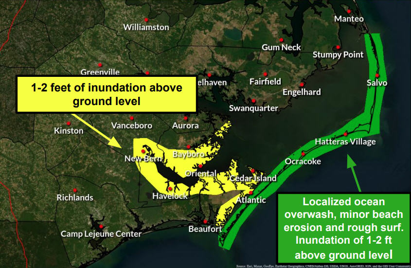
Maximum impact is expected Saturday afternoon and evening with high winds and waves, beach erosion, flattening of dunes, and ocean overwash on highways.
Maximum impact is expected Saturday afternoon and evening with high winds and waves, beach erosion, flattening of dunes, and ocean overwash on highways.
Maximum impact is expected Saturday afternoon and evening with high winds and waves, beach erosion, flattening of dunes, and ocean overwash on highways.
Maximum impact is expected Saturday afternoon and evening with high winds and waves, beach erosion, flattening of dunes, and ocean overwash on highways.
As the hurricane moves north of Hatteras and Ocracoke, the winds will shift to the northwest and bring a storm surge with heavy soundside flooding on the islands.
As the hurricane moves north of Hatteras and Ocracoke, the winds will shift to the northwest and bring a storm surge with heavy soundside flooding on the islands.
As the hurricane moves north of Hatteras and Ocracoke, the winds will shift to the northwest and bring a storm surge with heavy soundside flooding on the islands.
As the hurricane moves north of Hatteras and Ocracoke, the winds will shift to the northwest and bring a storm surge with heavy soundside flooding on the islands.
As visitors cleared off Hatteras and Ocracoke, residents were busy buying groceries, batteries, gas, and other supplies.
As visitors cleared off Hatteras and Ocracoke, residents were busy buying groceries, batteries, gas, and other supplies.
As visitors cleared off Hatteras and Ocracoke, residents were busy buying groceries, batteries, gas, and other supplies.
As visitors cleared off Hatteras and Ocracoke, residents were busy buying groceries, batteries, gas, and other supplies.
Islanders admitted to being very nervous about the seriousness of the storm, which some have said could be the most catastrophic on the Outer Banks in 40 or 50 years.
Islanders admitted to being very nervous about the seriousness of the storm, which some have said could be the most catastrophic on the Outer Banks in 40 or 50 years.
Islanders admitted to being very nervous about the seriousness of the storm, which some have said could be the most catastrophic on the Outer Banks in 40 or 50 years.
Islanders admitted to being very nervous about the seriousness of the storm, which some have said could be the most catastrophic on the Outer Banks in 40 or 50 years.
Many were watching and listening to the weather news and waiting until Friday morning to make a decision about evacuation.
Many were watching and listening to the weather news and waiting until Friday morning to make a decision about evacuation.
Many were watching and listening to the weather news and waiting until Friday morning to make a decision about evacuation.
Many were watching and listening to the weather news and waiting until Friday morning to make a decision about evacuation.
However, most seemed inclined to stay put despite warnings from officials that there will be no emergency services and that power, telephones, and maybe even cell phones would be out.
However, most seemed inclined to stay put despite warnings from officials that there will be no emergency services and that power, telephones, and maybe even cell phones would be out.
However, most seemed inclined to stay put despite warnings from officials that there will be no emergency services and that power, telephones, and maybe even cell phones would be out.
However, most seemed inclined to stay put despite warnings from officials that there will be no emergency services and that power, telephones, and maybe even cell phones would be out.
As always, islanders are worried about how long it might be before they can return home after a storm, and Irene brings with it a real threat of cutting new inlets or destroying sections of Highway 12.
As always, islanders are worried about how long it might be before they can return home after a storm, and Irene brings with it a real threat of cutting new inlets or destroying sections of Highway 12.
As always, islanders are worried about how long it might be before they can return home after a storm, and Irene brings with it a real threat of cutting new inlets or destroying sections of Highway 12.
As always, islanders are worried about how long it might be before they can return home after a storm, and Irene brings with it a real threat of cutting new inlets or destroying sections of Highway 12.
The National Park Service has closed all beaches, campgrounds, and visitor centers in the seashore.
The National Park Service has closed all beaches, campgrounds, and visitor centers in the seashore.
The National Park Service has closed all beaches, campgrounds, and visitor centers in the seashore.
The National Park Service has closed all beaches, campgrounds, and visitor centers in the seashore.
By evening, most services and businesses were shut down or shutting down. Some grocery stores and gas stations remained open.
By evening, most services and businesses were shut down or shutting down. Some grocery stores and gas stations remained open.
By evening, most services and businesses were shut down or shutting down. Some grocery stores and gas stations remained open.
By evening, most services and businesses were shut down or shutting down. Some grocery stores and gas stations remained open.
The NCDOT Ferry Division expected to close down all ferries this evening, except the Hatteras-Ocracoke route, which will operate on the hour with two boats on Friday for as long as conditions allow.
The NCDOT Ferry Division expected to close down all ferries this evening, except the Hatteras-Ocracoke route, which will operate on the hour with two boats on Friday for as long as conditions allow.
The NCDOT Ferry Division expected to close down all ferries this evening, except the Hatteras-Ocracoke route, which will operate on the hour with two boats on Friday for as long as conditions allow.
The NCDOT Ferry Division expected to close down all ferries this evening, except the Hatteras-Ocracoke route, which will operate on the hour with two boats on Friday for as long as conditions allow.
There are no emergency shelters in Dare or Hyde counties.
Shelter information for Dare County residents
On Friday morning at 10 a.m., the state of North Carolina will open the following two shelters for Dare County evacuees:
TJ Davis Recreation Center, 400 E. Sixth Street, Roanoke Rapids, NC 27870. (252) 533-2847. Pets will not be co-located at this shelter, but accommodations will be available and information will be provided upon arrival.
Northampton Cultural & Wellness Center, 9536 Hwy 305 North, Jackson, NC 27845. (252) 534-1303. Pets will be co-located at this site.
Dare County residents without a means of transportation to a state managed shelter outside of Dare County should call 252-475-5640 on Friday from 8:30 a.m. to 5 p.m. to make travel arrangements.
Those with special medical needs should contact 252-475-5655 for assistance.
Pet owners should make plans to evacuate with their pets, as the Dare County Animal Shelter is unable to accommodate the drop-off of pets by evacuees. Additional information about pet care during storms is available at www.obxspca.org
Shelter Information for Hyde County residents
Shelters will be provided at:
Nash County opened at shelter at Inglewood Baptist Church, 1350 S.Winstead Avenue, Rocky Mount, NC at 8 a.m. on Thursday for Ocracoke Island evacuees. Pets will not be co-located, but accommodations will be available and info provided upon arrival.
Wilson County opened a shelter at Raleigh Road Baptist Church, 4150 Raleigh Road Parkway, Wilson, NC 27893, also this morning for mainland Hyde County evacuees. Pets will not be co-located, but accommodations will be available and info provided upon arrival.
WEATHER INFORMATION
WEATHER INFORMATION
WEATHER INFORMATION
WEATHER INFORMATION
Latest watches, warnings, and local Hurricane Irene statements at http://www.erh.noaa.gov/er/mhx/
MORE DARE COUNTY INFORMATION
The Dare County Control Group has activated the Joint Information Section (JIS) in response to Hurricane Irene. All information regarding local government agencies in Dare County will be released through this source effective today, Wednesday, Aug. 24.
The JIS is a collaborative organization that encompasses the six municipal governments in Dare County, the National Park Service, the Dare County Sheriff’s Office, and the County of Dare, all of which have representatives on the Dare County Control Group. The JIS is operated in the Emergency Operations Center (EOC) in Manteo and managed by Dare County Emergency Management.
Outlets for information include the following:
The Dare County website at www.darenc.com
Government Access Channel 20, Charter Cable Channel 20
Releases e-mailed and faxed to local, regional, and national press outlets
Emergency Management Public Phone Inquiry Line at 252-475-5655
Other Important Numbers:
NCDOT inside North Carolina: 511
NCDOT inside North Carolina: 511
NCDOT inside North Carolina: 511
NCDOT inside North Carolina: 511
NCDOT outside North Carolina: 1-877-DOT-4YOU (1-877-638-4968)
NCDOT outside North Carolina: 1-877-DOT-4YOU (1-877-638-4968)
NCDOT outside North Carolina: 1-877-DOT-4YOU (1-877-638-4968)
NCDOT outside North Carolina: 1-877-DOT-4YOU (1-877-638-4968)
North Carolina Highway Patrol: 1-800-441-6127
North Carolina Highway Patrol: 1-800-441-6127
North Carolina Highway Patrol: 1-800-441-6127
North Carolina Highway Patrol: 1-800-441-6127
Virginia DOT: 1-800-367-7623
Virginia DOT: 1-800-367-7623
Virginia DOT: 1-800-367-7623
Virginia DOT: 1-800-367-7623
NC Ferry Service: 1-800-BY-FERRY
NC Ferry Service: 1-800-BY-FERRY
NC Ferry Service: 1-800-BY-FERRY
NC Ferry Service: 1-800-BY-FERRY
Dominion/North Carolina Power: 1-866-DOM-HELP (1-866-366-4357)
Dominion/North Carolina Power: 1-866-DOM-HELP (1-866-366-4357)
Dominion/North Carolina Power: 1-866-DOM-HELP (1-866-366-4357)
Dominion/North Carolina Power: 1-866-DOM-HELP (1-866-366-4357)
Cape Hatteras Electric: 1-866-511-9862
Cape Hatteras Electric: 1-866-511-9862
Cape Hatteras Electric: 1-866-511-9862
Cape Hatteras Electric: 1-866-511-9862
Tideland Electric: 1-800-637-1079
Tideland Electric: 1-800-637-1079
Tideland Electric: 1-800-637-1079
Tideland Electric: 1-800-637-1079
North Carolina Attorney General (Price Gouging): 919-716-6000 (Outside NC) and 877-566-7226 (Inside NC)
North Carolina Attorney General (Price Gouging): 919-716-6000 (Outside NC) and 877-566-7226 (Inside NC)
North Carolina Attorney General (Price Gouging): 919-716-6000 (Outside NC) and 877-566-7226 (Inside NC)
North Carolina Attorney General (Price Gouging): 919-716-6000 (Outside NC) and 877-566-7226 (Inside NC)
No new re-entry stickers are available at this time. The previously issued stickers, for 2008/2009, are still valid. Residents can also use a North Carolina driver’s license showing a Dare County address. Property owners may present a Dare County tax bill with proper identification for reentry.
No new re-entry stickers are available at this time. The previously issued stickers, for 2008/2009, are still valid. Residents can also use a North Carolina driver’s license showing a Dare County address. Property owners may present a Dare County tax bill with proper identification for reentry.
No new re-entry stickers are available at this time. The previously issued stickers, for 2008/2009, are still valid. Residents can also use a North Carolina driver’s license showing a Dare County address. Property owners may present a Dare County tax bill with proper identification for reentry.
No new re-entry stickers are available at this time. The previously issued stickers, for 2008/2009, are still valid. Residents can also use a North Carolina driver’s license showing a Dare County address. Property owners may present a Dare County tax bill with proper identification for reentry.
The public and media should dial 911 in case of emergency only.
The public and media should dial 911 in case of emergency only.
The public and media should dial 911 in case of emergency only.
The public and media should dial 911 in case of emergency only.
Subject
Name
(required, will not be published)
(required, will not be published)
City :
State :
Your Comments:
May be posted on the Letters to the Editor page at the discretion of the editor.
May be posted on the Letters to the Editor page at the discretion of the editor.
May be posted on the Letters to the Editor page at the discretion of the editor.
May be posted on the Letters to the Editor page at the discretion of the editor.


