Tropical system may threaten Outer Banks on July 4
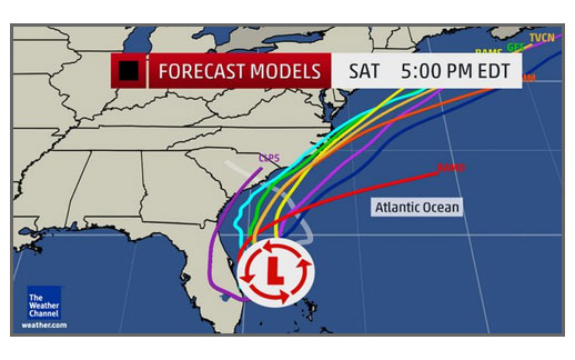
A low pressure area that is now almost stationary off the coast of central Florida may well be threatening the Outer Banks by July 4.
The National Hurricane Center gives the low an 80 percent chance of becoming a tropical storm very soon, and some models take it to hurricane strength by the end of the week.
If it does become a tropical storm later tonight or tomorrow, it will be named Arthur.
Although there is still uncertainty in the track and intensity, forecasters are saying it could be a “disruptive” storm on the holiday weekend for the coast of the Carolinas and perhaps the northeastern U.S.
This afternoon an NWS Hurricane Hunter aircraft found winds of 30 to 35 mph in the storm — they must reach 39 mph to become a tropical storm. The thunderstorms are not now wrapped around the low, which is about 200 miles across — but are mostly to the south.
The disturbance, currently being called Invest 91-L, is currently caught between high pressure systems — one to the east and one to the west, which is keeping it in place for now, and some dry air is mixing in from the north. By later in the week, a dip in the jet stream and an approaching front are expected to lift the storm north along the southeast coast of the U.S.
Most models are starting to agree that the storm will pass very close to the Outer Banks. However, whether it will be inshore or offshore of the barrier island and the intensity are still unknowns.
In the short term, the system will drift west or southwest toward the Florida coast and start lifting north about Wednesday.
The forecast is for the storm to start intensifying Wednesday and Thursday off the South Carolina coast.
By July 4, it will be off the North Carolina coast, and will probably move very close to the Outer Banks — probably at its maximum intensity.
Two models that forecasters often look at — the USGFS and the European model (ECMWF) –have the storm just offshore off of Cape Hatteras about mid-day on Friday. The European model is currently predicting winds at 86 knots and the GFS, about 60 knots.
Of course, it is still possible that the low will not behave as forecast. We are not guaranteed a tropical storm or a hurricane. The storm could not intensify or it could pass far offshore, and we might get only thunderstorms and some wind on Hatteras and Ocracoke.
As they would with any storm so close to the U.S. and over very warm Gulf Stream waters, forecasters and emergency managers are paying very close attention. And some businesses, especially rental management companies are starting to make contingency plans for later this holiday week when the Outer Banks will be jammed with visitors.
The National Weather Service in Newport, N.C., is forecasting increasing chances of precipitation and higher winds and seas by Thursday, continuing into Friday.
Dare and Hyde county Emergency Management Offices are monitoring the storm.
Residents and visitors should be aware of changing weather conditions, keep up with the local and tropical forecasts on radio, television, or the Internet, and listen for any announcements from emergency management.
The local NWS weather service office in Newport’s website is http://www.weather.gov/mhx/. The National Hurricane Center can be found at http://www.nhc.noaa.gov/.


